

BPSC AEDO · Module 13 · standard depth · 14 min
Natural vegetation and forest cover
What BPSC AEDO asks from this chapter
Syllabus lines this chapter covers:
- Paper 2: General Studies · General geography; major geographical divisions of Bihar and its important rivers
BPSC AEDO questions from this module are being sorted into our bank.
Cut to standard depth for BPSC AEDO. 11 deeper paragraphs are in the full chapter.
Start from zero: why do forests look so different?
Imagine taking a train from Kerala to Rajasthan. In Kerala you pass through dark, dense, green forests where the sunlight hardly reaches the ground. In central India the trees are tall but drop their leaves in summer, and in Rajasthan only scattered thorny bushes stand on sandy land.
All of these are examples of natural vegetation. This means plants that have grown on their own, without being planted or tended by people, and that have been left undisturbed for a long time. Crops, gardens and orchards are not natural vegetation, because people planted them.
Why do forests differ so much? The most important reason is rainfall, followed by temperature. Where rain is heavy and the air warm all year, trees grow tall and stay green. Where rain is less or comes in one season, trees shed their leaves to save water, and where rain is very low, only hardy shrubs survive.
That is why India's forest types follow its rainfall zones closely, as the rainfall map of India shows. Two other factors add variety: height in the mountains, where it gets colder as you climb, and salt water along the coasts, where only special plants can grow.
Why it matters. Forests give timber, fuel, fodder, medicines and food, and many tribal communities depend on them for their livelihood. They also hold soil, recharge groundwater, reduce floods and store carbon. So the state of India's forests is directly linked to water security, rural livelihoods and climate change.
Forests of the plains and plateaus: evergreen, deciduous and thorn
Where rainfall is above 200 cm and the dry season is short, we find tropical evergreen forests. They grow on the western slopes of the Western Ghats, in the hills of the north-east and on the Andaman and Nicobar Islands. Because there is no season when water runs short, the trees never shed all their leaves at once, so the forest stays green all year.
These forests are very dense and grow in several layers, from tall trees reaching 60 m down to shrubs and creepers on the ground. They are home to valuable hardwoods such as ebony, mahogany and rosewood, but the trees grow mixed together, which makes commercial logging difficult.
Where rainfall is between about 70 and 200 cm, the most widespread forests of India grow, the tropical deciduous or monsoon forests. Their trees shed their leaves for six to eight weeks in the dry summer to reduce water loss. In the wetter part, with about 100 to 200 cm of rain, moist deciduous forests grow along the eastern slopes of the Western Ghats, the north-eastern states, the foothills of the Himalaya and parts of Odisha and Jharkhand, with teak, sal, sandalwood and bamboo.
In the drier part, dry deciduous forests cover large areas of the peninsular plateau and the plains of Bihar and Uttar Pradesh. As the rainy season ends, the forest floor turns bare and open, and teak, sal and tendu are common. These forests have been heavily cleared for farming and grazing.
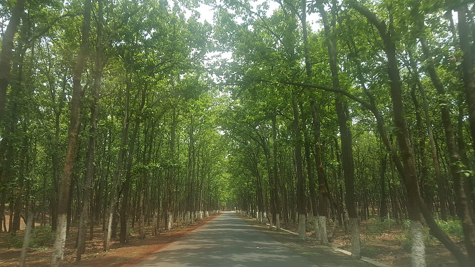
Where rainfall is below about 70 cm, in north-western India and the dry interior of the Deccan, only tropical thorn forests and scrubs survive. Plants such as acacia, babool and cactus have long roots to reach deep water and small, thick or thorny leaves to cut evaporation.
Why it matters. Each forest type supports a different economy. Evergreen forests are rich in biodiversity, deciduous forests supply most of India's commercial timber and minor forest produce such as tendu leaves, and thorn forests support herders. Protecting them requires different strategies, from biodiversity reserves to community grazing rules.
Mountain forests and mangroves
In the mountains, temperature falls as height increases, so climbing a mountain is like travelling towards the poles. The vegetation therefore changes in belts with height. On the lower slopes of the Himalaya, deciduous and subtropical forests grow, much like those of the plains below.
Higher up, between roughly 1,000 and 2,000 m, wet temperate forests of evergreen broad-leaved trees such as oak and chestnut grow. Above them, up to about 3,000 m, coniferous forests of pine, deodar, silver fir and spruce appear. These trees have needle-like leaves and a cone shape that sheds snow easily.
Still higher, near the snow line, trees become stunted, and alpine vegetation of shrubs, mosses and lichens takes over. Here lie the alpine meadows or grasslands, which herders such as the Gujjars and Bakarwals use in summer for grazing.
At the other end of the land, along salty tidal coasts, a very different forest grows: the mangroves. They are salt-tolerant trees and shrubs that survive in muddy, waterlogged soil flooded by the tides twice a day. Many have breathing roots that stick up out of the mud.
Mangroves are found along the deltas of the eastern coast, the Gujarat coast and the Andaman and Nicobar Islands. West Bengal, with the Sundarbans delta of the Ganga and Brahmaputra, has the largest mangrove area in India, followed by Gujarat and the Andaman and Nicobar Islands.
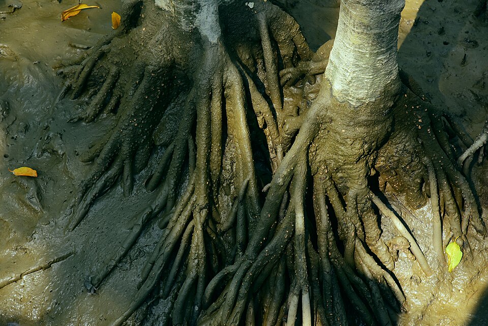
Why it matters. Himalayan forests protect slopes from landslides and feed the rivers of north India. Mangroves are natural sea walls: their tangled roots reduce the force of storm surges, tsunamis and erosion, and they shelter fish breeding grounds. Losing them makes coastal villages far more exposed to cyclones.
Classifying forests: types and legal categories
Foresters needed a common language to describe India's huge variety of forests. The standard system was prepared by the foresters Champion and Seth, whose revised classification of 1968 is still used. It sorts forests mainly by climate, and then by soil, landform and the main plant species, into groups such as tropical wet evergreen, tropical moist deciduous, tropical thorn, montane and littoral and swamp forests.
Forests are also classed by law, which decides how strongly they are protected. Reserved forests have the strongest protection, and most activities, such as grazing or cutting, are banned unless specially allowed. Protected forests allow some local use, such as grazing, unless it is specifically forbidden, while unclassed forests are recorded as forest but not yet placed in either category.
This leads to an important difference that confuses many students. Recorded forest area is land shown as forest in government records, whether or not it actually has trees. Forest cover is land that is actually covered by tree canopy, as seen in satellite images, whatever its legal status.
So a recorded forest can have very few trees, while a dense private orchard or village grove can count as forest cover. This is why the two figures for India are different, and why exams often test which one a statement refers to.
Why it matters. Legal categories decide who can use a forest and how, which affects tribal and forest-dwelling communities directly. The gap between recorded forest area and actual forest cover shows where forests have been degraded on paper-protected land. Planners use both measures to decide where to protect and where to restore.
How much forest does India have?
India's forests are measured by the Forest Survey of India (FSI), based in Dehradun. Every two years, it uses satellite images to map forest cover across all states and districts and publishes the results as the India State of Forest Report (ISFR). The first such assessment was made in 1987.
FSI sorts forest cover by canopy density, meaning how much of the ground is shaded by tree crowns when seen from above. Very dense forest has a canopy density of 70% or more, moderately dense forest has 40 to 70%, and open forest has 10 to 40%. Land with stunted trees and a canopy below 10% is called scrub, and it is not counted as forest cover.
FSI also measures tree cover, which means small patches and rows of trees outside recorded forests, such as trees on farms, along roads and in villages. Forest cover and tree cover are added together to judge progress towards the national goal.
That goal comes from the National Forest Policy, 1988, which says that one-third (33%) of India's geographical area should be under forest or tree cover. According to the ISFR 2023, forest cover is about 21.76% of the country's area, and forest and tree cover together are about 25.17%. So India is still well short of the one-third target.
Forest cover is very uneven. The north-eastern states, the Himalayan states and the Andaman and Nicobar Islands have a high share of their area under forest, while the plains states of the north-west and the Gangetic plain have very little. Much of the recent gain has come from tree cover outside forests rather than from dense natural forest.
Why it matters. Forest figures guide policies on climate, water and wildlife, and they are used in India's climate commitments to build an additional carbon sink. But a rise in total cover can hide a loss of dense natural forest, because plantations and orchards also count. That is why answers should look at the quality of forests, not just their area.
Losing and saving forests
India's forests have been shrinking for centuries. In the colonial period, large areas were cut for timber, especially for railway sleepers and shipbuilding, and forests were brought under state control. After independence, forests continued to be cleared for farms, dams, mines, roads and towns.
Other causes of deforestation work quietly every year. They include shifting cultivation in the hills, encroachment on forest land, illegal felling, forest fires and overgrazing by cattle and goats. The loss of forests leads to soil erosion, floods, falling groundwater and loss of wildlife habitat, and it can push wild animals into conflict with people.
To slow this loss, the Forest (Conservation) Act, 1980 made it necessary to get the Central Government's prior approval before forest land is used for non-forest purposes such as mining or projects. When such approval is given, the project usually has to pay for compensatory planting elsewhere.
People have also protected forests through their own action. In the Chipko movement of the 1970s in the hills of present-day Uttarakhand, villagers, many of them women, hugged trees to stop them from being felled. The Bishnoi community of Rajasthan has protected trees and wild animals for centuries as part of its faith.
Joint Forest Management, in which forest departments and village communities share the work and benefits of protecting forests, grew from experiments such as the one at Sukhomajri in Haryana. Today, afforestation programmes and the Green India Mission aim to restore degraded forests and increase tree cover.
Why it matters. Forest policy has to balance development, such as mines and roads, with ecology and the rights of forest-dwelling people. The success of community efforts shows that forests are best protected when local people gain from them. This balance between growth and conservation is a recurring theme in Mains questions.
Quick revision
- Natural vegetation grows on its own and is shaped mainly by rainfall, then temperature, relief and soil, so India's forest types follow its rainfall zones.
- Tropical evergreen forests (above 200 cm) grow on the Western Ghats, the north-east and the islands, with ebony, mahogany and rosewood.
- Tropical deciduous forests are the most widespread; moist ones (100–200 cm) have teak, sal and sandalwood, and dry ones cover large parts of the plateau.
- Thorn forests (below about 70 cm) of acacia, babool and cactus grow in the north-west and the interior Deccan.
- In the mountains, oak and chestnut, then pine, deodar, fir and spruce, then alpine meadows follow one another with height.
- Mangroves are salt-tolerant coastal forests that shield coasts, and West Bengal (Sundarbans) has the largest area.
- FSI, Dehradun reports forest cover every two years; canopy classes are very dense (70%+), moderately dense (40–70%) and open (10–40%), and below 10% is scrub.
- The National Forest Policy 1988 set a 33% target; ISFR 2023 puts forest cover at about 21.76% and forest plus tree cover at about 25.17%.