

BPSC ASO · Module 25 · standard depth · 12 min
World soils, soil-forming processes and soil erosion
What BPSC ASO asks from this chapter
Syllabus lines this chapter covers:
- Preliminary: General Knowledge (General Studies 50, General Science and Mathematics 50, Mental Ability 50) · General science: physics, chemistry, biology, geography
- Mains Paper 2: General Knowledge (General Studies 50, General Science and Mathematics 50, Mental Ability 50) · General science: physics, chemistry, biology, geography
BPSC ASO questions from this module are being sorted into our bank.
Cut to standard depth for BPSC ASO. 11 deeper paragraphs are in the full chapter.
Start from zero: why soils differ around the world
Pick up a handful of soil in a tea garden of Assam, a wheat field in Punjab and a pine forest in Canada, and you will find three very different materials. One is red and sticky, one is soft and grey-brown, and one is acidic with a pale layer under the leaves. Each is the product of the place where it formed.
Soil is the thin layer of loose material on the Earth's surface, made of broken rock, organic matter, water and air, in which plants grow. It forms very slowly; a few centimetres can take hundreds of years. Soil scientists say five factors control how soil develops: parent material, topography, climate, biological activity and time.
On a local scale, the parent rock and slope can matter most. On a world scale, however, climate is the strongest control, because temperature and rainfall decide how fast rocks weather, how much water moves through the soil and how quickly organic matter decays. Climate also decides the natural vegetation, which supplies the organic matter.
This is why world soil maps look much like climate and biome maps. Soils of the rainforest, the grassland, the desert and the taiga are as different from one another as the vegetation above them.
A typical good soil is roughly half solid matter and half pore space. The solid part is mostly mineral particles of sand, silt and clay with a small but vital share of organic matter, and the pores hold air and water. The balance of sand, silt and clay, called soil texture, decides how well the soil holds water and nutrients.
Why it matters. Soils decide what crops a region can grow and how much food it can produce. Understanding why they differ helps farmers and planners use them wisely.
Soil-forming processes: what climate does to soil
Under different climates, water and organic matter move through the soil in different ways, producing distinct soil-forming processes. Four of them explain most of the world's major soils.
Laterisation happens in hot, wet tropical regions. Heavy rain and high temperatures break down rocks deeply and wash away silica and bases such as calcium and potassium, a process called leaching. What remains are iron and aluminium oxides, which give the soil a red colour and can harden into a brick-like crust when exposed, forming laterite. Such soils are poor in nutrients unless manured.
Podzolisation happens in cool, moist climates under coniferous forests. Fallen needles form an acidic layer, and rainwater passing through it dissolves iron and aluminium from the upper soil and carries them down. This leaves a pale, ash-grey layer near the surface, which gives the podzol its name, from a Russian word for ash, and a rusty layer below.
Calcification happens in semi-arid grasslands, where evaporation is greater than rainfall. Water does not leach the soil fully, so calcium carbonate collects in the lower layers, while dense grass roots add a thick, dark, humus-rich top layer. This forms the black chernozem and the browner chestnut soils.
Two more processes occur in special conditions. Gleisation takes place where soils are waterlogged, as in the tundra and marshes, giving bluish-grey gley soils, while salinisation occurs in dry areas or over-irrigated fields, where evaporation draws water upward and leaves salts at the surface.
Why it matters. These processes explain why tropical soils need careful management, grassland soils are rich and taiga soils are acidic. They also explain salt damage in irrigated dry lands.
Classifying soils: zonal, intrazonal and azonal
Early soil scientists, especially in Russia, grouped soils into three broad classes. Zonal soils are mature soils whose character is shaped mainly by climate and vegetation, so they occur in broad zones matching climate belts. Laterites, podzols, chernozems and desert soils are examples.
Intrazonal soils are shaped more by local conditions than by climate. Waterlogged gley soils, saline soils of dry basins and soils formed on limestone are examples, and they can occur within any climatic zone.
Azonal soils are young soils that have not had time to develop distinct layers. River alluvium on floodplains and deltas, fresh volcanic ash, loose sand dunes and thin soils on steep mountain slopes are azonal, since new material keeps being added or removed. Much of the fertile alluvium of the Ganga plain is of this kind.
Modern scientists often use the soil taxonomy of the United States Department of Agriculture, which groups soils into 12 orders using measurable properties. Examples include Oxisols, the deeply weathered soils of the humid tropics; Mollisols, the dark grassland soils; Spodosols, the podzols of cool forests; Aridisols of deserts; and Entisols, young soils with little development. India's soil survey has also classified Indian soils under this scheme.
Why it matters. Classification lets scientists compare soils across countries and predict how they will respond to crops, fertilisers and irrigation. It links soil maps with land-use planning.
The great soil belts of the world
Matching soils with biomes gives a clear world pattern. In the humid tropics, under rainforests and wet savannas of the Amazon, Congo, South-East Asia and parts of India, laterites and latosols dominate. They are deep and red but poor, and crops do well only with careful use of fertilisers and organic matter.
In the hot deserts, soils are thin, sandy or stony and light in colour, with very little organic matter, and salts often collect near the surface. With irrigation, as in the Nile valley or parts of the Thar, some desert soils can become productive, though salinity is a constant danger.
In the temperate grasslands, the Steppes of Ukraine and Russia, the Prairies, and the Pampas, lie the black chernozems and the drier chestnut soils. Chernozems, with a deep, crumbly, humus-rich top layer, are among the most fertile soils on Earth, which is why these regions became the world's granaries. Under the temperate deciduous forests of western Europe and the eastern United States, brown forest soils are moderately fertile and well suited to mixed farming.
Further north, beneath the taiga, the acidic podzols are poor for farming, so most of this belt remains under forest. Along the Arctic coasts, tundra soils are thin, waterlogged gley soils over permafrost. In the Mediterranean lands, red soils formed on limestone, called terra rossa, support vines and olives.
Why it matters. The world soil belts explain the global map of farming, from plantation crops in the tropics to wheat in the grasslands. They also show where soils are most fragile.
Soil erosion: losing the skin of the Earth
Soil erosion is the removal of the top layer of soil by water, wind or ice faster than new soil can form. Because the top layer holds most of the organic matter and nutrients, its loss reduces fertility, sometimes permanently.
Water erosion takes several forms. Sheet erosion removes a thin, even layer over a wide area and often goes unnoticed. When water collects into small channels, it cuts rills, and when these deepen and widen, they become gullies, which can turn farmland into badlands, as in the ravines of the Chambal valley.
Wind erosion is serious in dry and semi-arid areas, where loose, dry soil lacks plant cover. Strong winds lift fine particles and carry them far away, as in the dust bowl of the American Prairies in the 1930s, when drought and over-ploughing turned farmland into dust storms.
Nature erodes soil slowly, but human activities speed it up greatly. Deforestation, overgrazing, ploughing up and down slopes, leaving fields bare between crops, shifting cultivation with short fallow periods and badly planned construction all expose soil to rain and wind.
The problem is global. The Food and Agriculture Organization's assessment of the world's soil resources found that about a third of the world's soils are moderately to highly degraded, through erosion, loss of organic matter, salinity, compaction, acidification and pollution. Erosion is especially severe in parts of Africa, South Asia, China and Latin America, where growing populations farm steep or dry land.
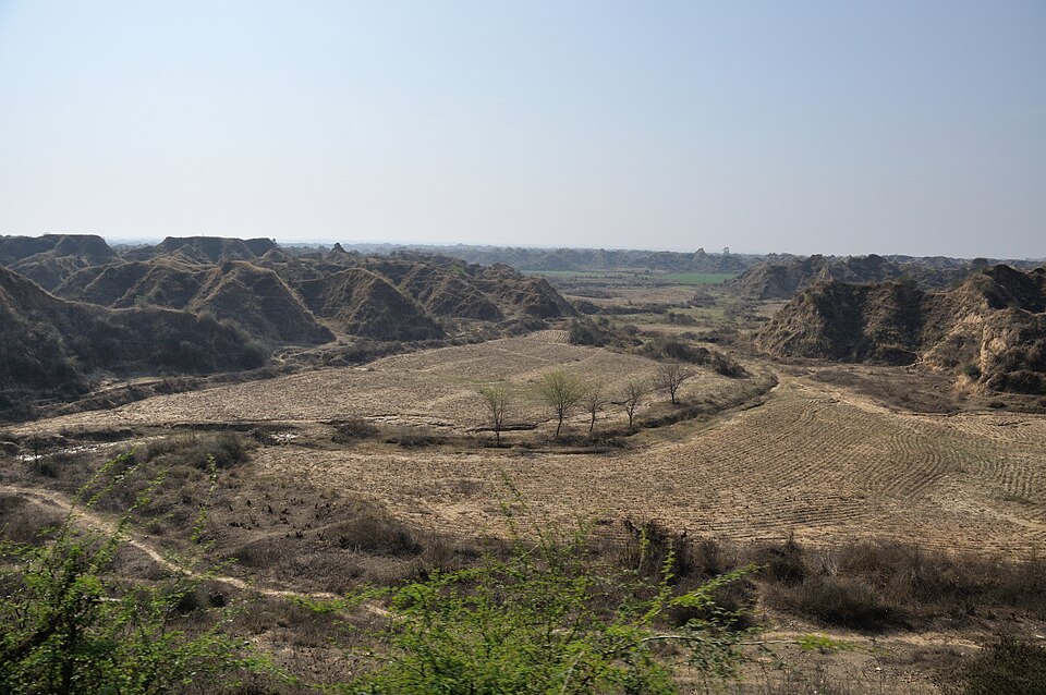
Why it matters. Soil erosion reduces crop yields, silts up reservoirs and rivers and worsens floods. Since soil forms very slowly, eroded land is effectively lost for generations.
Saving the soil
Soil conservation means protecting soil from erosion and keeping it fertile. On slopes, farmers plough along the contours rather than up and down, so each furrow holds back water. On steep hills, they build terraces, flat steps cut into the slope, as seen in the rice terraces of the Himalaya, South-East Asia and the Andes.
Strip cropping alternates rows of crops that leave the soil bare with strips of grass or legumes that hold it. In dry areas, shelter belts of trees planted across the wind slow it down and reduce wind erosion. Check dams and bunds across gullies trap silt and slow runoff.
Covering the soil also helps. Mulching, spreading crop residues or leaves on the surface, protects soil from the impact of raindrops and keeps it moist. Cover crops grown between main crops, crop rotation with legumes, organic manure and controlled grazing keep soil both covered and fertile. On a larger scale, afforestation and watershed management treat whole catchments.
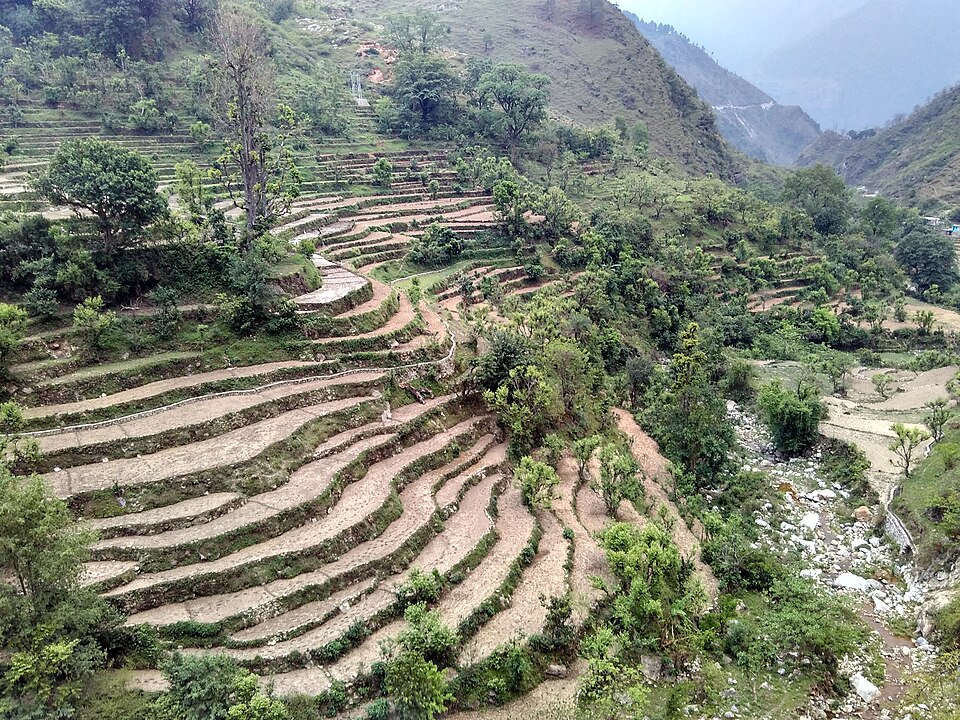
The world now recognises soil as a vital but limited resource. The Food and Agriculture Organization promotes World Soil Day on 5 December, and 2015 was the International Year of Soils. India runs soil health cards and watershed programmes to guide farmers on soil care.
Why it matters. Healthy soil is the base of food security and stores more carbon than all plants and the atmosphere together. Conservation protects both farmers' incomes and the climate.
Quick revision
- Five factors: parent material, topography, climate, biological activity, time; climate dominant worldwide.
- Laterisation: hot, wet tropics; silica leached, iron and aluminium remain; red laterite.
- Podzolisation: cool, moist, coniferous; ash-grey leached layer; podzols of the taiga.
- Calcification: semi-arid grasslands; lime in lower layers; chernozem, chestnut soils.
- Gleisation: waterlogged (tundra, marshes); salinisation: dry areas, salts at surface.
- Zonal (climate), intrazonal (local), azonal (young, e.g. alluvium).
- USDA: 12 orders; Oxisols, Mollisols, Spodosols, Aridisols, Entisols.
- Belts: laterite (tropics), desert soils, chernozem (grasslands), brown forest, podzol (taiga), tundra; terra rossa (Mediterranean).
- Erosion: sheet, rill, gully; wind; badlands; dust bowl.
- Conservation: contour ploughing, terracing, strip cropping, shelter belts, check dams, mulching, cover crops.
- World Soil Day: 5 December; 2015 International Year of Soils.