

BPSC Auditor, Panchayati Raj Dept · Module 13 · standard depth · 12 min
Continental drift, sea-floor spreading and plate tectonics
What BPSC Auditor, Panchayati Raj Dept asks from this chapter
Syllabus lines this chapter covers:
- Prelims: General Studies · General geography and geography of Bihar
BPSC Auditor, Panchayati Raj Dept questions from this module are being sorted into our bank.
Cut to standard depth for BPSC Auditor, Panchayati Raj Dept. 11 deeper paragraphs are in the full chapter.
Start from zero: do continents move?
Look at a world map and you may notice that South America's east coast and Africa's west coast look like two pieces of a torn photograph. For centuries, mapmakers noticed this match, but nobody could explain it. Could continents, made of solid rock, really have moved apart?
The answer, accepted only in the 1960s, is yes. The Earth's outer shell is broken into huge slabs called plates, which move a few centimetres a year, about as fast as your fingernails grow. Over millions of years, such slow motion opens oceans, closes seas and pushes up mountains.
This idea, called plate tectonics, is to geography what evolution is to biology. It ties together the shapes of continents, the depth of oceans, and the location of mountains, volcanoes and earthquakes.
Why it matters. Plate movements explain why the Himalaya exist, why northern India shakes in earthquakes, why the 2004 tsunami struck and why minerals are found where they are. Without plate tectonics, most of physical geography would be a list of unexplained facts.
Wegener's continental drift
The idea that continents might have moved was suggested by the Dutch mapmaker Abraham Ortelius as early as 1596. But the first full theory came from the German meteorologist Alfred Wegener, who presented his continental drift theory in 1912.
Wegener argued that all continents were once joined in a single supercontinent he called Pangaea ("all lands"), surrounded by a single ocean, Panthalassa ("all seas"). Pangaea later split into a northern part, Laurasia (also called Angaraland), and a southern part, Gondwanaland, with a long, narrow sea, the Tethys, between them. These later broke into the continents we know.
He gathered strong evidence. The coastlines fit like a jigsaw, especially when the edges of the continental shelves are matched. Rocks of the same age and type, and old mountain belts, line up across the Atlantic between Brazil and West Africa and between North America and Europe.
Fossils tell the same story. Mesosaurus, a small freshwater reptile, is found only in Brazil and southern Africa; it could not have swum across an ocean. Fossils of the land reptile Lystrosaurus and the fern-like plant Glossopteris occur across South America, Africa, India, Antarctica and Australia.
Ancient climates also fit. Deposits left by ice sheets, called tillite, about 300 million years old, are found in India, Africa, South America, Australia and Antarctica, some now in hot tropical lands. They make sense only if these lands were once joined near the South Pole. Coal, formed in warm swamps, is found in today's cold lands.
Why it matters. Wegener showed that many separate puzzles had one solution. His idea of Gondwanaland also explains why the oldest rocks and coal of India resemble those of Africa and Australia, which is why Indian coal-bearing rocks are called "Gondwana".
Why the theory was first rejected
Wegener's evidence was strong, but his explanation of how continents moved was weak. He suggested two forces. A polar-fleeing force, linked to the Earth's rotation and bulging equator, would push continents towards the equator. Tidal forces of the Sun and Moon would drag them westward.
Physicists calculated that these forces were far too small to move whole continents. Wegener also imagined light continents (sial) ploughing through the denser ocean floor (sima), which seemed impossible. So most scientists rejected drift for about forty years.
In the late 1920s, the British geologist Arthur Holmes offered a better engine. He suggested that heat from radioactive decay inside the Earth sets up slow convection currents in the mantle, rising under some areas and sinking under others, like water in a heated pot. These currents could act like conveyor belts, splitting continents apart where they rise and crumpling them where they sink.
Holmes' idea had little direct evidence at the time. Proof came only after the Second World War, when new tools allowed scientists to study the ocean floor in detail.
Why it matters. This story shows that a correct idea can be rejected when its mechanism is missing, and accepted when new evidence arrives. Answers on the evolution of theories can use it to show how science weighs evidence and explanation.
Sea-floor spreading: the missing proof
After 1945, ships using echo-sounding mapped the ocean floor and found surprises. A vast chain of underwater mountains, the mid-ocean ridges, runs for tens of thousands of kilometres through all the oceans, with a rift valley along its crest. Deep trenches lie near some continents.
Rocks on the ocean floor turned out to be young: nowhere older than about 200 million years, while continental rocks can be over 3 billion years old. Rocks get older with distance from the ridge, and the layer of sediment on top gets thicker away from the ridge. Volcanoes and shallow earthquakes cluster along the ridge.
The strongest proof came from magnetism. When lava cools, its iron minerals record the direction of the Earth's magnetic field, which reverses every so often. Surveys found matching stripes of normal and reversed magnetism on both sides of the ridges, like a mirror image.
In the early 1960s, the American geologist Harry Hess explained all this as sea-floor spreading. Magma rises at the ridges, cools into new ocean floor and spreads outward on both sides, carrying the magnetic record like a tape recorder. Since the Earth is not getting bigger, old ocean floor must sink back into the mantle at the trenches, a process called subduction.
Why it matters. Sea-floor spreading supplied the mechanism Wegener lacked and turned drift into plate tectonics. It also explains why the oldest rocks are on continents and why oceans open and close over geological time.
Plate tectonics: plates and their boundaries
By the late 1960s, these ideas combined into the theory of plate tectonics. The lithosphere, the rigid outer shell made of the crust and the top of the mantle, is broken into large plates that move over the weak asthenosphere. A plate can carry both continent and ocean floor; it is the plate that moves, not the continent alone.
There are seven major plates: the Pacific, North American, South American, Eurasian, African, Indo-Australian and Antarctic plates. Smaller plates include the Nazca, Cocos, Arabian, Philippine and Caribbean plates.
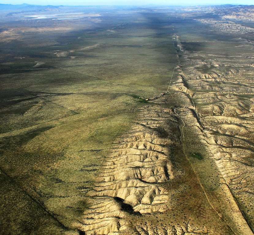
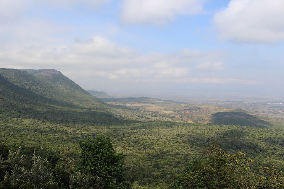
Plates meet at three kinds of boundaries. At divergent (constructive) boundaries, plates move apart and new crust forms, as along the Mid-Atlantic Ridge; on land, the same process forms rift valleys such as the East African Rift. At transform (conservative) boundaries, plates slide past each other without creating or destroying crust, as along the San Andreas Fault in California, causing strong earthquakes.
At convergent (destructive) boundaries, plates collide, in three ways. When two oceanic plates meet, one sinks and volcanoes build island arcs such as Japan and the Philippines. When ocean meets continent, the heavier ocean plate sinks beneath the continent, forming a trench and a volcanic mountain chain such as the Andes. When two continents collide, neither sinks easily, so the crust crumples into great fold mountains such as the Himalaya.
What moves the plates? Mantle convection provides the heat, ridge push shoves plates away from high ridges, and slab pull, the weight of a cold plate sinking at a subduction zone, drags the rest behind it. Slab pull is now thought to be the strongest of these forces.
Most earthquakes and volcanoes occur along plate boundaries. The rim of the Pacific, ringed by subduction zones, is called the Ring of Fire. Volcanoes in the middle of plates, such as Hawaii, are explained by hot spots, plumes of hot mantle rising beneath a moving plate.
Why it matters. Boundary type predicts hazards. Subduction zones bring the biggest earthquakes, tsunamis and explosive volcanoes, while collision zones like the Himalaya bring frequent quakes and landslides. Disaster planning, building codes and early-warning systems all start from the plate map.
India's journey and its consequences
India was once part of Gondwanaland, lying next to Africa, Antarctica and Australia. As Gondwanaland broke up, the Indian plate separated and moved north across the Tethys Sea, unusually fast for a plate.
On its way, the plate passed over a hot spot, and enormous lava flows poured out to build the Deccan Traps near the end of the age of dinosaurs. About 40–50 million years ago, India collided with Asia. The sediments of the Tethys were squeezed and lifted, and the Himalaya began to rise.
The collision has not stopped. The Indian plate still pushes north into Asia, so the Himalaya are still rising, and stress builds up along faults beneath them. This is why the Himalayan belt and the North-East suffer frequent earthquakes, and why the Andaman and Nicobar Islands, lying on a subduction zone to the east, are prone to earthquakes and tsunamis, as in 2004.
Plate movement also shaped India's landforms. The old, stable Peninsula is a fragment of Gondwanaland, the Himalaya are young fold mountains, and the Northern Plains lie in the trough between them, filled by river sediments.
Today, plate movement is no longer inferred only from rocks; it is measured directly. Networks of satellite-linked GPS stations across India and the Himalaya record the ground shifting by a few centimetres each year. Comparing these motions shows where strain is building up, which helps scientists judge which stretches of the Himalaya may be due for a large earthquake.
Why it matters. India's physical divisions, its earthquake zones and its mineral belts are all products of this journey. Seismic zoning, building codes in Himalayan towns and the tsunami warning centre for the Indian Ocean are direct responses to plate tectonics.
Quick revision
- Wegener (1912): Pangaea + Panthalassa; Laurasia (Angaraland) and Gondwanaland split by the Tethys.
- Evidence: jigsaw fit, matching rocks and mountain belts, Mesosaurus, Lystrosaurus, Glossopteris, tillite.
- Rejected because forces (polar-fleeing, tidal) were too weak. Holmes (late 1920s): mantle convection.
- Sea-floor spreading (Hess, early 1960s): ridges, young ocean floor (under about 200 million years), magnetic stripes, subduction at trenches.
- Seven major plates: Pacific, North American, South American, Eurasian, African, Indo-Australian, Antarctic.
- Boundaries: divergent (Mid-Atlantic Ridge, East African Rift), convergent (Japan, Andes, Himalaya), transform (San Andreas).
- Forces: convection, ridge push, slab pull (strongest). Ring of Fire; hot spots such as Hawaii.
- India: from Gondwanaland, over a hot spot (Deccan Traps), collision about 40–50 million years ago; Himalaya still rising.