Paper 2: General Knowledge (General Studies, General Science and Mathematics, Mental Ability) · General science: physics, chemistry, biology, geography
BPSC LDC questions from this module are being sorted into our bank.
Cut to basic depth for BPSC LDC. 32 deeper paragraphs are in the full chapter.
Start from zero: what moves the air around the planet?
Stand on a rooftop on a hot afternoon and you can feel the wind on your face. That wind is part of a much bigger system that circles the whole planet. To understand it, we need only three simple ideas.
Three ideas behind every wind
First, air moves from high pressure to low pressure. Where air is heated it expands and rises, so it presses less on the ground and the pressure there is low. Where air is cooled, or where it piles up from above, it presses more and the pressure is high. Air then flows from the high towards the low, just as water flows downhill, and this moving air is what we call wind.
Second, the spinning Earth turns the wind. Because the Earth rotates, moving air does not travel in a straight line. It is turned to the right in the northern hemisphere and to the left in the southern hemisphere. This turning effect is called the Coriolis force, and it is why the great winds of the world blow at an angle instead of straight from high to low.
Third, a wind is named after the direction it comes from. A wind that blows from the west towards the east is a westerly, and one that comes from the north-east is a north-easterly. Keep this rule in mind, because many exam questions test it.
Why it matters. With these three ideas you can explain why deserts are dry, why the equator is rainy and why India's rains arrive in one season. The sun heats the Earth unevenly, and the air tries to even out that difference by moving. The pressure belts and winds in this chapter are simply that effort, seen on the scale of the whole planet.
The world's pressure belts
Zoom out to the whole Earth. The sun heats the equator most and the poles least. Warm air rises near the equator and cool or crowded air sinks elsewhere, and together this sets up a neat pattern of pressure belts that circle the globe like stripes on a ball. From the equator to each pole:
The seven pressure bands of the world
Equatorial low (near the equator): strong heating all year makes air rise, so pressure is low. Its calm belt of light, shifting winds is called the doldrums.
Subtropical highs (along about 30° N and 30° S): air that rose at the equator sinks here, so pressure is high and the air is dry. Its calm belt is called the horse latitudes.
Sub-polar lows (along about 60° N and 60° S): warm air from lower latitudes meets cold polar air and is forced up, so pressure is low and the weather stormy.
Polar highs (near the poles): intense cold makes dense air sink, so pressure is high.
Because sinking air in the subtropical highs is dry, many of the world's great hot deserts lie in or near these latitudes. Examples are the Sahara, Arabia, the Thar, the Kalahari and the Australian deserts.
Counted across both hemispheres, that is seven bands: one equatorial low and three on each side of it.
The belts are not fixed. They move with the apparent movement of the sun. In the northern summer, when the overhead sun moves towards the Tropic of Cancer, the whole system shifts north; in the northern winter it shifts south.
Hot deserts lie under the subtropical highs
The shift is only a few degrees of latitude, but for a country like India it changes everything: it decides whether a place is under dry sinking air or moist rising air at a given time of year. That is why the arrival and retreat of India's rains follow this seasonal shift.
Why it matters. The pressure belts are a first map of where the world is wet and where it is dry. Rising air at the equator gives rainforests; sinking air near 30° gives deserts. Because the belts shift with the sun, a place on their edge gets a wet season and a dry season. Much of India lies in exactly such a zone, which is why our year is split into a rainy monsoon and long dry months.
Planetary winds and the three-cell model
Pressure belts tell us where air is pushed from and to. Add the Coriolis turn, and we get the great planetary winds that blow over most of the Earth for most of the year. Scientists explain them with a three-cell model in each hemisphere.
Planetary winds and the three-cell model
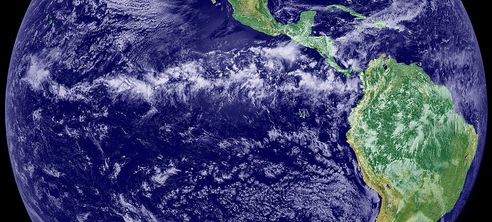
The Hadley cell (equator to about 30°). At the equator, high insolation heats the air; it rises by convection and creates the Inter Tropical Convergence Zone (ITCZ), a belt of low pressure where winds from both hemispheres converge. The rising air cools, forms tall clouds and gives heavy rain, which is why equatorial forests are so wet.
High up, the air moves towards the poles, cools and sinks around 30° N and S, building the subtropical highs. From there, surface air flows back towards the equator to complete the loop. These surface winds are the trade winds.
Planetary winds on the world map
The Coriolis force bends them: in the northern hemisphere they come from the north-east (north-east trades), and in the southern hemisphere from the south-east (south-east trades). Since they blow from the east, they are also called easterlies. Sailing ships of earlier centuries used these steady winds to cross the Atlantic, which is how they got their name.
The Ferrel cell (middle latitudes). Between about 30° and 60°, surface air flows from the subtropical highs towards the poles, to the sub-polar lows. The Coriolis turn makes these winds come from the west, so they are the westerlies. In this cell, warm air rising near 60° and air sinking near 30° work together, so it behaves like a gear driven by the two cells on either side.
The ITCZ seen from space as a band of clouds near the equatorPhoto: Wikimedia Commons, Public domain, via Wikimedia Commons
The Polar cell. Over the poles, cold dense air subsides to form the polar high and then flows outward towards the middle latitudes. Deflected by the Coriolis force, these become the polar easterlies.
Put together, from the equator outward in each hemisphere you have: ITCZ and doldrums, trade winds, horse latitudes, westerlies, sub-polar low, polar easterlies, polar high. These winds move heat from the hot equator towards the cold poles. Without this circulation, the tropics would keep getting hotter and the poles colder.
Why it was worked out, and why it matters. Scientists first drew this circulation to answer a sailors' puzzle: why did the trade winds blow so steadily from the east, year after year? The answer, a loop of rising and sinking air bent by the Earth's turning, became the base of modern climate science. The planetary winds shaped history too: the trade winds and westerlies set the sea routes of the age of sail. Today the same pattern tells us where deserts spread, where rain falls and how heat travels from the tropics to the poles.
Quick revision
Air moves from high to low pressure, the spinning Earth turns it, and a wind is named after the direction it comes from.
There are seven pressure bands: the equatorial low, the subtropical highs (30°), the sub-polar lows (60°) and the polar highs. They shift with the sun through the year.
The calm belt at the equator is the doldrums, and the calm belt of the subtropical highs is the horse latitudes.
Each hemisphere has three cells. The Hadley cell drives the trade winds, the Ferrel cell the westerlies and the Polar cell the polar easterlies, and the ITCZ is where the trade winds meet near the equator.
Land and sea, and the moving sun, break the neat belts into cells, and the monsoon is the largest example of this.
The sea breeze blows by day and the land breeze by night. Likewise, the valley breeze blows by day and the mountain wind by night.
The loo is the hot, dry wind of the northern plains in May and June, and it is fiercest between Delhi and Patna.
Exam-style questions on this chapter. Pick an answer to see the explanation. 0 of 7 answered
The subtropical high-pressure belts lie along about:
Consider the following statements:
1. The world's pressure belts are permanent and do not move during the year.
2. In the northern summer the pressure belts shift northwards.
Which of the statements given above is/are correct?
The westerlies blow from:
The Inter Tropical Convergence Zone (ITCZ) is a zone of:
Consider the following statements:
1. A sea breeze blows from the sea to the land during the day.
2. A land breeze forms because the land cools faster than the sea at night.
Which of the statements given above is/are correct?
The 'loo' is:
Which of the following pairs of local wind and region is correctly matched?
Mains answer practice
Write your answer first, then open the points a good answer should cover.
Explain the general circulation of the atmosphere with the help of the three-cell model. How does the distribution of land and sea modify it? (250 words)
Show answer points
forces (PGF, friction, Coriolis)
pressure belts and their shift
Hadley/Ferrel/Polar cells with trades, westerlies, polar easterlies
Previous year questions for UPSC CSE will appear here once each one is checked word for word against the official question paper.
Frequently asked questions
What are the trade winds?
Trade winds blow from the subtropical highs towards the equatorial low. Deflected by the Coriolis force, they blow from the north-east in the northern hemisphere and the south-east in the southern.
What are the Roaring Forties?
They are the strong westerly winds of the southern hemisphere between about 40° and 50° S, where open ocean lets them blow without obstruction by land.
What is the loo?
The loo is a hot, dry and dusty wind that blows over the north-western plains of India in May and June afternoons and can cause heatstroke.
What is the difference between the foehn and the chinook?
Both are warm, dry winds that descend the leeward side of mountains and warm up as they sink. The foehn blows in the Alps, and the chinook on the eastern slopes of the Rockies.