

BPSC LDC · Module 28 · basic depth · 13 min
Water resources and irrigation
What BPSC LDC asks from this chapter
Syllabus lines this chapter covers:
- Paper 2: General Knowledge (General Studies, General Science and Mathematics, Mental Ability) · Geography, economic affairs, Indian agriculture and natural resources, five-year plans
BPSC LDC questions from this module are being sorted into our bank.
Cut to basic depth for BPSC LDC. 17 deeper paragraphs are in the full chapter.
Start from zero: how much water does India really have?
Imagine a bucket left out in the rain for a whole year. In India it would fill with about a metre of water on average, but almost all of it in four monsoon months, and very unevenly: more than 10 metres at some places in Meghalaya and less than 15 centimetres in parts of the Thar. That is India's water story in one picture: plenty in total, but concentrated in time and space.
Every year India receives about 4,000 billion cubic metres (BCM) of water as rain and snow. A large part evaporates, sinks deep into the ground or rushes to the sea in floods, and the terrain and storage limit what we can actually capture. Only about 1,122 BCM is utilisable: roughly 690 BCM from rivers, lakes and reservoirs, and 432 BCM from groundwater.
India has about 4 per cent of the world's fresh water but a far larger share of its people, so the water available per person is low and falling as population grows. Many river basins and cities already face water stress, meaning demand comes close to or exceeds the renewable supply.
Why it matters. Water decides where farming, industry and cities can grow. Managing it well is central to food security, health, energy and the future of India's agriculture.
Surface water: rivers, basins and reservoirs
Surface water is the water in rivers, streams, lakes, ponds, wetlands and reservoirs. India has around 20 river basins, of which 12 are major basins, and most of the country's surface water flows through a handful of them. A river basin is all the land drained by a river and its tributaries, so it is the natural unit for planning water.
The Himalayan rivers, the Indus, Ganga and Brahmaputra systems, are perennial. They are fed by snow and glaciers in summer and by the monsoon in the rainy season, so they flow all year. The Ganga–Brahmaputra–Meghna system alone carries well over half of India's river water, and the Brahmaputra has one of the highest flows of any river in the world.
The peninsular rivers, such as the Godavari, Krishna, Kaveri and Mahanadi flowing east and the Narmada and Tapi flowing west, are rain-fed and largely seasonal. Their flow swells in the monsoon and shrinks greatly in the dry months, which is why they need dams and reservoirs to store water. The short, swift rivers of the Western Ghats carry a lot of water but only for a few months, and the streams of western Rajasthan form an inland drainage that ends in salt lakes or dies out in the sand.
Not all river water can be used. Much of the Brahmaputra's flow falls in a narrow valley with little farmland, and floods pass too quickly to store. So the utilisable surface water of a basin depends on its terrain, storage sites and demand, not just its volume.
Why it matters. Surface water is shared across states and countries, so it explains inter-state river disputes and treaties such as the Indus Waters Treaty and agreements with Bangladesh and Nepal.
Groundwater: the hidden reservoir under stress
Groundwater is rain and river water that has seeped into the ground and fills the spaces in soil and rock. A rock layer that stores and gives water is called an aquifer. Groundwater is replenished mainly by monsoon rain, and it supplies most rural drinking water and a large share of irrigation.
How much groundwater a region holds depends on its rocks. The deep, soft alluvium of the Indus–Ganga–Brahmaputra plains, the coastal plains and the deltas has many pores and can store huge volumes. The hard granite, gneiss and Deccan basalt of the peninsula hold water only in cracks, joints and weathered layers, so wells there yield less and dry up faster.
Since the Green Revolution, cheap pumps and subsidised or free electricity have led to an explosion of tube-wells. In the north-west, especially Punjab, Haryana, Rajasthan and Delhi, farmers and cities now pull out more groundwater each year than rain puts back, so water tables are falling steadily. Nationally, a significant share of assessment blocks are classed as over-exploited or critical, while most of the North-East and eastern India still use only a small part of their groundwater.
Quality is also a problem. Arsenic contaminates groundwater in parts of the Ganga–Brahmaputra plains and delta, in West Bengal, Bihar, Uttar Pradesh and Assam, and fluoride affects dry regions of Rajasthan, Gujarat, Telangana and Andhra Pradesh. Along the coasts, over-pumping lets sea water intrude into aquifers, making wells salty.
Why it matters. Groundwater is India's most important but least visible water source. Its overuse threatens farming in the food bowl of the north-west and the health of millions who drink contaminated water.
Irrigation: why India needs it and how it irrigates
Agriculture uses most of India's water. Irrigation is essential for three reasons. Rainfall is seasonal, so winter rabi crops need water from other sources; it is uneven, so dry regions cannot farm reliably without it; and it is unreliable, with delays and breaks in the monsoon. High-yielding seeds, fertilisers and growing two or three crops a year all depend on assured water.
India irrigates its fields in three main ways. Canals take water from rivers, either directly from perennial rivers through diversion canals, or from reservoirs behind dams. They dominate in the plains of Punjab, Haryana and western Uttar Pradesh and in the deltas of the east coast, where the land is flat and soil is soft.
Tanks are small reservoirs made by building an earthen bund across a stream or depression to store monsoon runoff. They are traditional in the peninsular south, in Tamil Nadu, Karnataka, Telangana and Andhra Pradesh, where hard rock makes wells difficult and the undulating land creates many natural hollows. Many old tanks have silted up or been encroached upon.
Wells and tube-wells are now the largest source of irrigation. They are popular because a farmer controls the timing and amount of water, but they draw on groundwater, which is why over-extraction has followed. Modern micro-irrigation, drip and sprinkler systems, supply water directly to roots and can save a large share of water compared with flooding fields.
Why it matters. Irrigation explains the Green Revolution's success and also today's water crisis. The shift from canals and tanks to tube-wells has made groundwater the hinge of India's food security.
Multipurpose projects, big dams and river links
After Independence, India built large multipurpose river valley projects, which store water behind a dam and use it for several purposes at once: irrigation, hydropower, flood control, drinking water, navigation, fisheries and tourism. Jawaharlal Nehru called the big dams the "temples of modern India".
The Damodar Valley Corporation, set up in 1948 and modelled on the Tennessee Valley Authority of the USA, was India's first multipurpose project. It was meant to tame the Damodar, once called the "sorrow of Bengal" for its floods, through dams such as Tilaiya, Konar, Maithon and Panchet, and it also supplies power to the industrial belt. Bhakra–Nangal on the Sutlej, with its Gobind Sagar reservoir, made the Green Revolution possible in Punjab, Haryana and Rajasthan.
Hirakud on the Mahanadi near Sambalpur, one of the longest earthen dams in the world, controls floods in the Odisha delta. The Chambal project, shared by Rajasthan and Madhya Pradesh, has three dams: Gandhi Sagar, Rana Pratap Sagar and Jawahar Sagar. Other landmarks are Nagarjuna Sagar on the Krishna, Tungabhadra, Sardar Sarovar on the Narmada and Tehri on the Bhagirathi.
Big dams also have costs. They submerge forests, farmland and villages, displacing large numbers of people, often tribal communities, who are not always properly resettled. Reservoirs fill with silt, block fish movement, change downstream flows and can trigger disputes between states. Movements such as the Narmada Bachao Andolan made these concerns national.
To move water from surplus to deficit basins, India plans to interlink rivers through canals and tunnels. The Ken–Betwa link in Bundelkhand is the first project taken up, but critics worry about cost, ecology, submerged forests and whether "surplus" basins truly have water to spare.
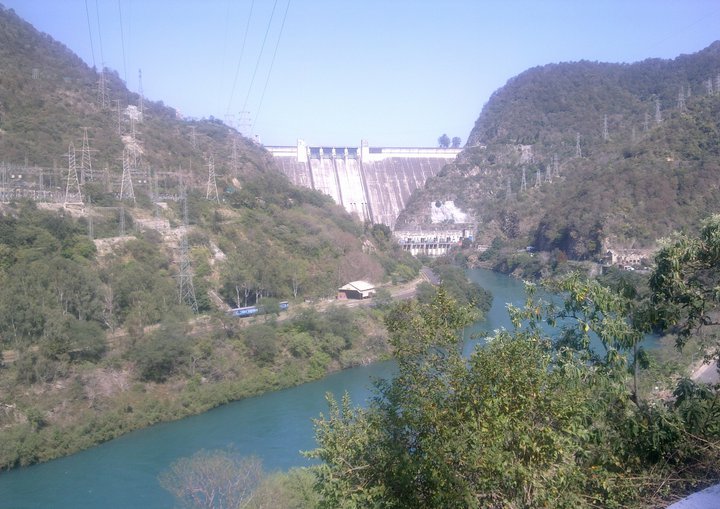
Why it matters. Dams and river links show the trade-off between development and ecology. Mains answers on water need to weigh irrigation and power against displacement and environmental damage.
Conserving water: old wisdom and new tools
Indian communities developed clever ways to catch and store rain long before modern dams. In the western Himalaya, kuls and guls are channels that divert stream and glacier water to fields. In Rajasthan, khadins hold runoff on farmland, johads are small earthen check dams that recharge wells, and tankas are underground tanks that store rooftop rainwater inside desert homes. The tanks of the south and the bamboo drip irrigation of Meghalaya are other examples.
Today these ideas are being revived as rainwater harvesting. Rooftop collection in cities, recharge pits, check dams and the restoration of ponds and tanks let rainwater soak into the ground instead of running off. Many cities and states now require rainwater harvesting in new buildings.
Watershed development treats a small catchment as one unit: bunds, trenches, tree planting and check dams slow down water, reduce soil erosion and recharge groundwater. Villages such as Ralegan Siddhi in Maharashtra and the work of community groups in Rajasthan showed how local action can revive dry streams.
Demand must be managed too. Micro-irrigation, less water-hungry crops in dry regions, accurate metering and pricing, treating and reusing urban wastewater, and community management of aquifers can stretch every drop further. Cleaning rivers of sewage and industrial waste protects both water quality and health.
Why it matters. Supply cannot keep growing forever, so conservation and demand management are the long-term answer. They also connect geography to local governance and community action.
Quick revision
- Precipitation about 4,000 BCM; utilisable about 1,122 BCM (690 surface + 432 groundwater).
- India: about 4 per cent of world fresh water, much larger share of people.
- Himalayan rivers perennial (snow + rain); peninsular rivers rain-fed, seasonal; G–B–M carries most surface water.
- Groundwater rich in alluvium, poor in hard rock; over-extraction in Punjab, Haryana, Rajasthan, Delhi.
- Arsenic: Ganga–Brahmaputra plains and delta; fluoride: dry regions; coastal salinity.
- Irrigation sources: wells/tube-wells largest; canals in northern plains and deltas; tanks in the south.
- DVC 1948 first multipurpose project; Bhakra–Nangal (Sutlej, Gobind Sagar); Hirakud (Mahanadi); Chambal (Gandhi Sagar, Rana Pratap Sagar, Jawahar Sagar).
- Traditional systems: kul/gul (Himalaya), khadin, johad, tanka (Rajasthan), tanks (south), bamboo drip (Meghalaya).
- River interlinking: Ken–Betwa first.