

GPSC Class 1-2 · Module 30 · Mains depth · 15 min
World resources, industries and choke points: where and why
What GPSC Class 1-2 asks from this chapter
Syllabus lines this chapter covers:
- General Studies · Geography of India, the world and Gujarat.
- GS 3 · Geography of India and Gujarat.
GPSC Class 1-2 questions from this module are being sorted into our bank.
Read at full depth: basics, the standard layer and the Mains analysis.
Start from zero: why is a factory where it is
Think of a sugar mill. Sugarcane is heavy, bulky and starts drying out soon after it is cut, so the mill must be close to the cane fields.
Now think of a bakery. Bread spoils quickly and is needed fresh every morning, so the bakery must be close to its customers. These two examples hold the key idea of this chapter.
An industry tries to locate where the total cost of producing and selling is lowest. That cost includes raw materials, power, labour, transport, water, capital and access to markets. Government policy, such as tax incentives or special economic zones, can also tip the balance.
When a raw material is heavy and loses weight in processing, like sugarcane, iron ore or coal, industry is pulled towards the source of the raw material. When the product is perishable, bulky or fragile, or must be close to buyers, industry is pulled towards the market. Industries that are pulled neither way are called footloose.
This logic was first set out as a theory by the German economist Alfred Weber in 1909. He argued that a factory settles where transport costs are lowest, then may shift towards cheap labour or towards other firms if the savings are large enough. Savings from clustering with other firms are called agglomeration economies. Later economists, notably Paul Krugman with his "new economic geography" in 1991, showed how such clusters grow stronger on their own.
Why it matters. This "where and why" logic is what Mains GS Paper I asks for under the location of industries. It lets you explain any industrial map instead of memorising it.
Heavy industries: iron and steel, aluminium, oil
Iron and steel is the classic raw-material industry. Making one tonne of steel once needed several tonnes of coal and iron ore, and both lose weight in the furnace. So the first great steel regions grew on coalfields: the Ruhr in Germany, the Midlands in Britain, Pittsburgh in the United States, and the Donbas in Ukraine. In India, Jamshedpur, Bhilai, Rourkela and Bokaro grew in the Chota Nagpur region, close to both coal and iron ore.
Over time, steelmaking used less coal per tonne, and cheap bulk shipping made it possible to bring ore and coal from far away. So many modern steel plants are built at ports, such as those in Japan, South Korea and coastal China, which import Australian and Brazilian ore. India's Visakhapatnam steel plant is a coastal example.
Aluminium smelting needs huge amounts of electricity, so it locates where power is cheap, often near hydroelectric plants, as in Norway, Canada and Iceland, rather than near bauxite mines. Oil refineries can be at the oilfields, but many are near markets or at ports, since crude oil is easy to move by pipeline and tanker while refined products go to many users. Jamnagar in Gujarat, one of the largest refining complexes in the world, sits on the coast to import crude and export products.
Why it matters. These cases show how changes in technology and transport shift industrial geography over time. They also explain why India's new steel and refining capacity is growing along the coast.
Light, agro-based and high-technology industries
Agro-based industries follow their raw materials when those spoil or lose weight. Sugar mills stand among cane fields, and tea is processed in factories on the estates themselves. Cotton textiles once clustered near cotton fields and humid climates, but because cotton does not lose weight, the industry later moved towards cheap labour, power and ports, as in Mumbai, Ahmedabad, and later Bangladesh, Vietnam and China.
Market-oriented industries make products that are bulky, fragile or perishable, or that need constant contact with customers. Examples include soft drinks, furniture, printing and bakery products. The motor-car industry assembles thousands of parts and tends to cluster around large markets and supplier networks, as in Detroit, Japan's Chūbu region, or Chennai and Gurugram–Manesar in India.
High-technology and footloose industries, such as software, electronics and biotechnology, use light, valuable materials, so transport costs matter little. They cluster where there are skilled workers, universities and research centres, venture capital and good connectivity. Silicon Valley in California, Bengaluru, Hyderabad and the Shenzhen region of China are examples. Such clusters, called agglomerations, grow stronger because firms gain from being near each other.
Why it matters. India's industrial future depends on building such skill-based clusters. Understanding agglomeration helps explain why policy focuses on industrial corridors and technology parks.
Straits, canals and sea choke points
About four-fifths of world trade by volume moves by sea, and much of it must pass through a few narrow passages called choke points. A strait is a narrow sea passage between two land masses that links two larger bodies of water. If a choke point is blocked by conflict, piracy or an accident, ships must take long detours, and prices of oil and goods rise worldwide.
The most important choke points for India are in the Indian Ocean. The Strait of Hormuz carries a large share of the world's seaborne oil out of the Persian Gulf. The Bab-el-Mandeb and the Suez Canal connect the Indian Ocean with the Mediterranean and Europe. The Strait of Malacca, between the Malay Peninsula and Sumatra, is the shortest route between the Indian Ocean and the Pacific and one of the busiest shipping lanes in the world; the Sunda and Lombok straits through Indonesia are alternatives.
Other key straits include Gibraltar (Atlantic–Mediterranean), Dover (English Channel–North Sea), the Bosporus and Dardanelles (Black Sea–Mediterranean), the Bering Strait (separating Asia from North America), and the Palk Strait between India and Sri Lanka. The two great ship canals are the Suez Canal (1869), which is at sea level, and the Panama Canal (1914), which uses locks; the Kiel Canal in Germany links the North Sea with the Baltic.
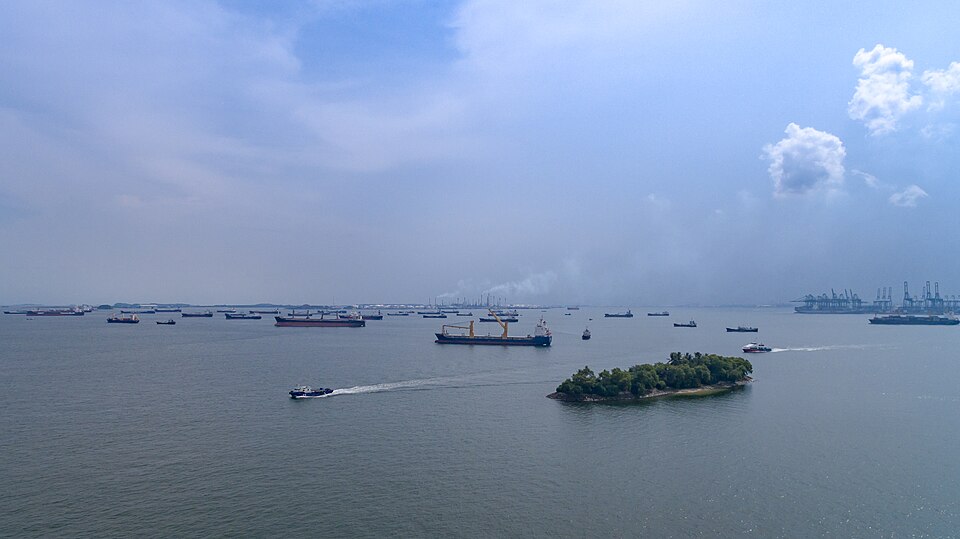
New routes are emerging. As Arctic sea ice shrinks, the Northern Sea Route along Russia's Arctic coast stays open longer each summer and offers a shorter path between Europe and East Asia. On land, long railways such as the Trans-Siberian Railway from Moscow to Vladivostok link continents.
Why it matters. India's energy security and trade depend on these sea lanes staying open. That is why the Indian Navy patrols the Gulf of Aden and the approaches to Malacca, and why India develops the Andaman and Nicobar Islands near the Malacca Strait.
Mountain passes: gateways through the ranges
A pass is a low gap in a mountain range that allows people, traders and armies to cross. Passes often form along river valleys or where glaciers have worn down a ridge. Throughout history they have been routes for trade, invasion and the spread of religions and ideas.
The Khyber Pass, between Pakistan and Afghanistan, was the main route of invaders and traders into the Indian subcontinent, and the Bolan Pass to its south led into Balochistan. In the Alps, the Brenner Pass links Austria and Italy, while the Simplon and St Gotthard passes link Switzerland and Italy, now with long rail and road tunnels beneath them.
India's Himalaya has many important passes. Zoji La links Srinagar with Leh, and Khardung La leads towards the Nubra valley in Ladakh. Shipki La in Himachal Pradesh, where the Sutlej enters India, and Nathu La and Jelep La in Sikkim are trade routes to Tibet, with Nathu La used for border trade and the Kailash Mansarovar Yatra. Bomdi La in Arunachal Pradesh and the Diphu Pass near the India–China–Myanmar trijunction lie in the east.
Why it matters. Himalayan passes are key to India's border security and to all-weather roads and tunnels, such as the Atal Tunnel and the Zoji La tunnel project. Questions on passes and their states are common in Prelims.
Changing geographical features
The map of the world is not fixed. The UPSC syllabus asks about changes in critical geographical features, including water bodies and ice caps, and their effects on flora and fauna. Some changes are natural and slow, while others are fast and caused by people.
Glaciers in the Himalaya, the Alps and the Andes are retreating as the climate warms, which will at first swell rivers and later reduce their summer flow. Arctic sea ice is shrinking, and the Greenland and Antarctic ice sheets are losing mass, raising sea level. Lakes have shrunk because of water diversion and drought: the Aral Sea in Central Asia lost most of its area after its rivers were used for cotton irrigation, and Lake Chad in Africa has shrunk sharply since the 1960s.
Deltas change as rivers bring less silt because of dams, while rising seas erode them, as in the Sundarbans and the Nile delta. Coral reefs bleach, and forests such as the Amazon shrink because of clearing and fire. New land also forms, through volcanic eruptions, river deposits and land reclamation.
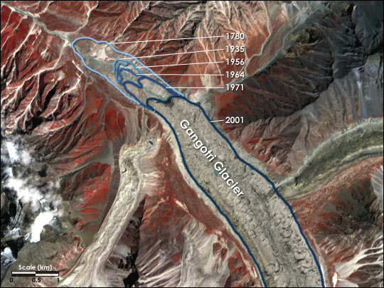
These changes affect flora and fauna. Shrinking sea ice threatens polar bears and seals, retreating glaciers change Himalayan rivers and ecosystems, and drying lakes destroy fisheries and wetlands used by migratory birds. They also affect people, through water shortages, displacement and the loss of livelihoods.
Why it matters. This syllabus line links physical geography with environment and current affairs. Answers score well when they connect a specific changing feature to its causes and its effects on life.
Mains lens: what, why, where and so what
This chapter directly serves GS Paper I (factors responsible for the location of primary, secondary and tertiary sector industries in various parts of the world, including India; geographical features and their location; changes in critical geographical features). It links to GS Paper III (energy security, infrastructure). Here are four angles.
1. Location logic. Raw material, power, market and footloose pulls.
2. Changing locations. From coalfields to ports; from cotton fields to cheap labour.
3. Choke points. Hormuz, Bab-el-Mandeb, Suez, Malacca and India's trade.
4. Changing features. Glaciers, ice caps, lakes and deltas, and their effects on life.
Mains lens: practice questions and answer plans
Now turn this understanding into written answers. The four questions below are written in the UPSC style, but they are our own practice questions, not previous-year questions. The real previous-year questions of your exam appear in the "Previous year questions" box once we have matched them with the official papers.
Q1. "Why are many new iron and steel plants located at ports rather than near mines? Explain with examples from the world and India." (150 words)
- Weight loss, bulk shipping, imported ore and coal.
- Japan, Korea, Visakhapatnam and coastal projects.
Q2. "Account for the concentration of high-technology industries in a few clusters across the world." (150 words)
- Skills, research, capital, connectivity, agglomeration.
- Silicon Valley, Bengaluru, Shenzhen.
Q3. "Identify the major maritime choke points of the Indian Ocean and discuss their significance for India." (250 words)
- Introduction: Define choke points with a map sketch.
- Body: Hormuz, Bab-el-Mandeb, Suez, Malacca; oil, trade, security.
- Conclusion: Naval presence, Andaman and Nicobar, alternative routes.
Q4. "Discuss how changes in critical geographical features such as glaciers and lakes affect flora and fauna. Give examples." (150 words)
- Himalayan glaciers, Arctic ice, Aral Sea, Lake Chad.
- Effects on species, wetlands and people.
Useful keywords: least-cost location, weight-losing raw material, market orientation, footloose industry, agglomeration, power-oriented aluminium, coastal steel plants, refineries at ports, Jamnagar, Silicon Valley, Bengaluru, choke point, Strait of Hormuz, Bab-el-Mandeb, Suez, Strait of Malacca, Sunda, Lombok, Gibraltar, Dover, Bering, Palk, Kiel Canal, Panama, Northern Sea Route, Trans-Siberian Railway, Khyber, Bolan, Brenner, Simplon, Zoji La, Shipki La, Nathu La, Bomdi La, glacier retreat, Aral Sea, Lake Chad, delta erosion.
Quick revision
- Location = lowest total cost: raw material, power, labour, transport, market, policy.
- Weber (1909): transport, labour, agglomeration; Krugman (1991): new economic geography.
- Weight-losing raw material → near source (sugar, steel once); perishable/bulky product → near market; footloose → skills and connectivity.
- Steel: coalfields (Ruhr, Pittsburgh, Chota Nagpur) → ports (Japan, Korea, Visakhapatnam). Aluminium → cheap power.
- High-tech clusters: Silicon Valley, Bengaluru, Shenzhen (agglomeration).
- Choke points: Hormuz, Bab-el-Mandeb, Suez, Malacca (busiest), Sunda, Lombok, Gibraltar, Dover, Bosporus, Bering, Palk.
- Canals: Suez 1869 (sea-level), Panama 1914 (locks), Kiel (North Sea–Baltic).
- Passes: Khyber, Bolan, Brenner, Simplon; Zoji La, Khardung La, Shipki La, Nathu La, Jelep La, Bomdi La, Diphu.
- Changing features: glacier retreat, Arctic ice, Aral Sea, Lake Chad, deltas, reefs.