

HPSC Engineering · Module 23 · standard depth · 18 min
Air pressure and the forces that move wind
What HPSC Engineering asks from this chapter
Syllabus lines this chapter covers:
- Screening test (general) · History of India; Indian and world geography
HPSC Engineering questions from this module are being sorted into our bank.
Cut to standard depth for HPSC Engineering. 12 deeper paragraphs are in the full chapter.
Start from zero: is air even real?
You cannot see air, so it is easy to forget that it is there. But try three small tests. Blow into a balloon: it swells, because air takes up space. Pump a cycle tube: the tube becomes hard, because air pushes.
Stand beside a road when a bus rushes past: dry leaves fly behind it, because moving air carries things. Air is real. It is made of countless tiny particles (molecules of nitrogen, oxygen and other gases) that are always moving and bumping into each other and into everything around them.
Now a second idea, the most important one in this whole topic: warm air rises. Watch the steam over a cup of hot tea, or a sky lantern on Diwali night floating upward. When air is heated, its particles move faster and spread apart.
The same amount of air now fills more space, so it becomes lighter for its size and floats up, like a cork in water. When air cools, its particles slow down and crowd together. It becomes heavier for its size and sinks.
Put the two ideas together. Imagine a hot, sunny field next to a cool pond. Over the field, warm air rises.
Something must fill the gap it leaves near the ground, so cooler air from over the pond slides in sideways. That sideways flow of air is what we call wind. In short:
- Heating makes air rise and leaves less air pressing down near the ground (low pressure).
- Cooling makes air sink and puts more air pressing down (high pressure).
- Air always tries to move from where there is more of it to where there is less: from high pressure to low pressure. That flow is wind.
Every big idea about winds, from a sea breeze at Marina Beach to the giant trade winds that sailing ships once used to cross oceans, is built on these three lines. One last everyday habit to learn now: a wind is named after the direction it comes from. A wind coming from the west is a "westerly", even though it is blowing towards the east.
Keep three questions in mind as you read: Why does air pressure differ from place to place? Which forces steer the moving air? And what pattern do the winds make over the whole Earth?
Air pressure: the weight of the sky above you
Think of a stack of quilts on a bed in winter. The quilt at the bottom is squashed the most, because every quilt above is pressing on it. The air around the Earth behaves the same way.
It is a deep blanket of gas held by gravity, and the air near the ground carries the weight of all the air above it. Atmospheric pressure is the weight of the column of air standing above a unit area of the Earth's surface.
We do not feel this weight because it presses on us from every side, and the air inside our bodies pushes back equally. But instruments can measure it. The mercury barometer is a glass tube of mercury standing upside down in a dish; air pressing on the dish pushes the mercury up the tube, and a higher column means higher pressure.
The aneroid barometer has no liquid: a small sealed metal box gets squeezed or relaxes as pressure changes, and a needle shows the reading. Weather scientists write pressure in millibars (mb). One millibar equals one hectopascal (hPa), so you will see both units on weather maps, and they mean the same number.
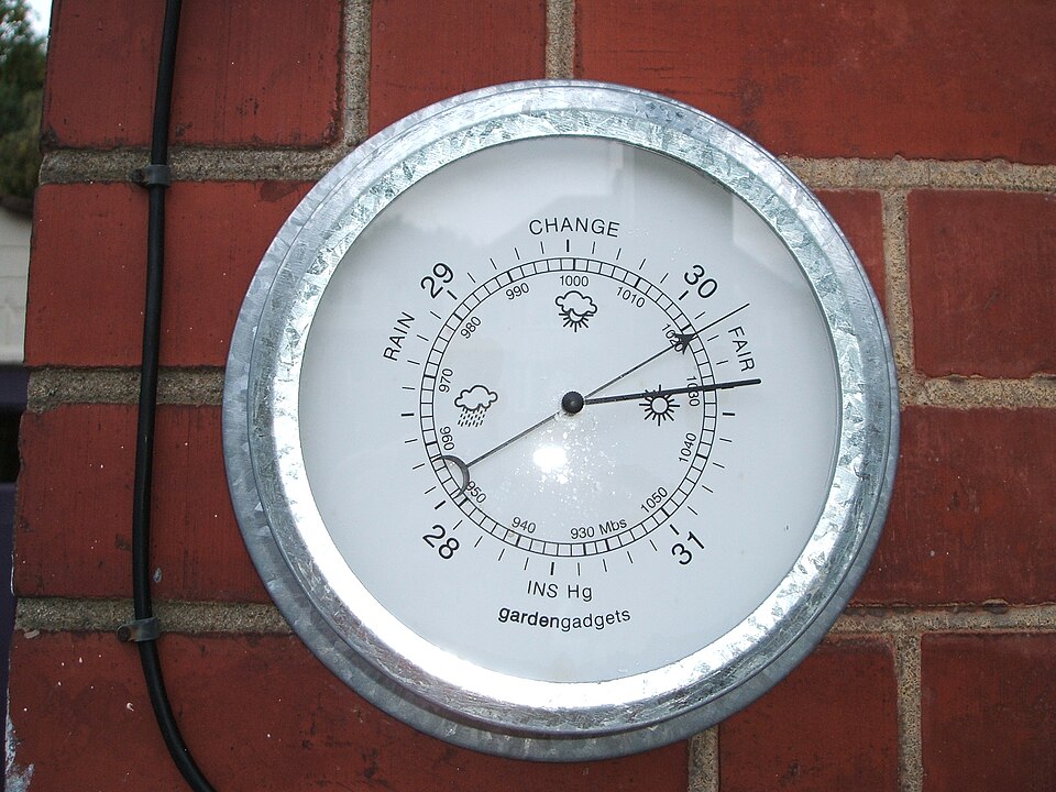
The standard sea-level pressure is 1,013.25 mb. This is the yardstick. A reading well below it suggests a low-pressure system; a reading well above it suggests a high.
Go back to the quilts. If you take some quilts off the top, the bottom one feels less weight. Climb a mountain and the same thing happens: there is less air above you, and that air is also thinner.
So pressure falls with height, and it falls fast in the lower atmosphere: by about 1 mb for every 10 m you climb. This is why mountaineers carry oxygen on very high peaks, and why your ears "pop" in an aircraft or on a winding hill road to Shimla or Darjeeling.
Because height changes pressure so much, a raw reading from a hill station cannot be compared directly with one from a coastal city. To compare places fairly, weather offices reduce every reading to what it would be at sea level. Only then do the differences tell us about the weather, not about the height of the station.
Why it matters. Pressure is the number that weather forecasting starts from. A steady fall in pressure over the Bay of Bengal is often the first sign that a depression or cyclone is forming, days before the wind arrives. That is why weather stations across India record pressure several times a day. The same idea also explains everyday things, like breathlessness on a trek or the sealed, pressurised cabin of an aircraft.
Isobars and the pressure gradient: reading the slope of the air
On a map of hills, contour lines join places at the same height. Where the lines are packed close together, the slope is steep and a ball would roll down fast. Where they are far apart, the slope is gentle.
Weather maps use the same trick for pressure. Isobars are lines joining places that have the same pressure (after reduction to sea level). A ring of isobars with the lowest value in the centre marks a low (L); a ring with the highest value in the centre marks a high (H).
The change of pressure over a distance is called the pressure gradient. Think of it as the "slope" of the air:
- Closely spaced isobars mean a steep pressure gradient. Air rushes down this slope, so winds are strong.
- Widely spaced isobars mean a gentle gradient and light winds.
This one rule lets you read any weather map. When a cyclone approaches the coast of Odisha or Andhra Pradesh, the isobars around its centre crowd into tight rings, and that crowding is the visual warning of dangerous winds. On a calm winter day over the plains, the isobars spread far apart and the air barely moves.
Remember the direction too: air moves from high to low, across the isobars, at least near the ground. As the next sections show, other forces then bend this simple path.
Why it matters. Isobars turn invisible air into a picture that anyone can read. When the weather office warns of a cyclone, the tight rings of isobars around its centre tell officials how strong the winds will be. That reading decides how many people must be moved to shelters and how early. A student who can read isobars can read the most important map in disaster management.
Why pressure differs: heat and the movement of air
If air pressure were the same everywhere, there would be no wind at all. So what makes it differ? There are two kinds of reasons.
1. Heating and cooling (thermal causes). Where the ground is strongly heated, as near the equator or over a hot desert in summer, the air above it warms, expands and rises. Less air now presses on the surface, so a low forms.
Where the ground is very cold, as over the polar ice, the air above it cools, contracts and sinks, piling more air onto the surface: a high forms. This is the tea-steam and sky-lantern idea we began with, now working on the scale of continents.
2. Movement and piling up of air (dynamic causes). Pressure can also change because of how air moves, not only because of local heat. Air that rises over the equator does not vanish; it flows towards the poles high up, cools, and some of it sinks back towards the surface around the subtropics.
Sinking air piles up and creates high pressure there, even though these latitudes are not cold. In the same way, where air spreads out and is drawn away near the surface, pressure falls. The high-pressure belts near 30° latitude and the low-pressure belts near 60° owe a great deal to this kind of movement, helped by the Earth's rotation.
Notice the loop that forms: air rises over a low, travels aloft, sinks over a high, and flows back along the surface from high to low. A vertical loop like this is called a circulation cell. A sea breeze is a tiny cell a few kilometres wide; the Hadley cell over the tropics is a giant one, thousands of kilometres across.
Why it matters. The rule "heating makes a low, cooling makes a high" is the single key that opens most of climatology. It explains why a hot Rajasthan in May pulls in air from the sea, and why cold Central Asia in winter pushes dry air outward. The second cause, air piling up, explains a puzzle that heat alone cannot: why some of the driest places on Earth lie near 30°, where it is warm, not cold. Keep both causes in mind and the pressure map of the world stops looking random.
Three forces that steer the wind
If only one force acted on air, wind would always blow straight from high to low. In reality three forces work together.
1. Pressure gradient force (the push). This is the force that starts the wind. It points from high to low pressure, and the steeper the gradient (the closer the isobars), the stronger the push. Without it, nothing would move.
2. Frictional force (the brake). Air dragging over trees, buildings, hills and rough ground slows down. Friction is greatest at the surface and its influence generally reaches up to about 1 to 3 km. Over the smooth sea surface friction is minimal, which is one reason winds over the ocean blow faster and steadier than over land, and why cyclones weaken quickly once they cross the coast.
3. Coriolis force (the turn). Now the surprising one. Imagine you and a friend sit on a spinning merry-go-round in a park.
You roll a ball straight towards your friend. To someone standing outside, the ball goes in a straight line. But to you, sitting on the turning platform, the ball seems to curve away, because your friend has moved round by the time it arrives.
The Earth is a giant merry-go-round, turning once a day. Air that moves a long distance across its surface appears to bend. This apparent bending, caused by the Earth's rotation, is the Coriolis force:
- In the northern hemisphere it deflects moving air to the right.
- In the southern hemisphere it deflects moving air to the left.
- It increases with latitude: it is maximum at the poles and absent at the equator.
That last point has a big consequence. Because there is no Coriolis force exactly at the equator, winds there do not spin up into a whirl, and tropical cyclones do not form right on the equator.
Putting the three together: the geostrophic wind. High up, a kilometre or more above the ground, friction is absent. There the pressure gradient force pushing air towards the low and the Coriolis force bending it sideways come into balance, and the wind ends up blowing parallel to the isobars instead of across them.
This is the geostrophic wind. Near the ground, friction weakens the Coriolis turn, so surface winds blow at an angle across the isobars towards the low.
Why it matters. Without the Coriolis force, winds would rush straight into a low and fill it quickly, and cyclones could not spin up or last. Because the force is zero at the equator, almost no cyclones form within a few degrees of it. Friction explains why a cyclone is most violent over the sea and weakens after landfall. Together, these three forces explain where storms are born, which way they turn and when they die.
Whirls around lows and highs
Now combine the push towards the low with the turn from the Coriolis force. Picture air from all sides rushing towards a low in the northern hemisphere. Each stream is bent to its right, so instead of meeting head-on in the middle, the air swirls round the centre anticlockwise.
This is cyclonic circulation. In the southern hemisphere the bend is to the left, so the swirl round a low is clockwise.
Around a high the air flows outward, and the same bending makes it turn the other way:
| Northern hemisphere | Southern hemisphere | |
|---|---|---|
| Low (cyclone) | Anticlockwise, inward | Clockwise, inward |
| High (anticyclone) | Clockwise, outward | Anticlockwise, outward |
Watch a satellite picture of a cyclone in the Bay of Bengal on the news: the cloud bands spiral anticlockwise. A cyclone near Australia or Madagascar spirals the other way. In a low, air also rises at the centre, cools and forms clouds and rain; in a high, air sinks, warms and keeps the sky clear and dry. That is why lows bring bad weather and highs bring settled, sunny weather.
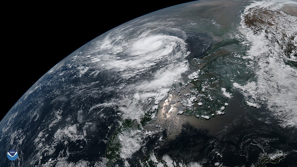
A handy rule for the northern hemisphere: stand with your back to the wind, and the low pressure is on your left. (In the southern hemisphere it is on your right.)
Why it matters. Lows and highs are the "weather makers" of everyday life. A low brings rising air, clouds and rain; a high brings sinking air, clear skies and, in winter, cold calm nights. Over north India in winter, calm high-pressure conditions let smoke and dust collect near the ground, which is one reason air quality gets worse in that season. So the same physics that turns a cyclone also decides whether a city can breathe clean air.
Quick revision
- Air pressure is the weight of the column of air above a place. We measure it with a mercury or aneroid barometer, in millibars (1 mb equals 1 hPa).
- Standard sea-level pressure is 1,013.25 mb. In the lower atmosphere it falls by about 1 mb for every 10 m of height, so the air on high mountains is thin and water boils at a lower temperature.
- Isobars join places of equal pressure. When they are close together, the pressure gradient is steep and the wind is strong.
- Wind blows from high to low pressure. It takes its name from the direction it comes from.
- Three forces act on wind. The pressure gradient force pushes it, friction slows it near the ground (up to 1-3 km, least over the sea), and the Coriolis force turns it.
- The Coriolis force turns winds to the right in the northern hemisphere and to the left in the southern. It is greatest at the poles and zero at the equator.
- The geostrophic wind blows parallel to the isobars in the upper air, where there is no friction.
- In the northern hemisphere, air turns anticlockwise around a low and clockwise around a high. In the southern hemisphere the directions are reversed.