

HPSC HCS · Module 25 · Mains depth · 17 min
Waves, tides and ocean currents
What HPSC HCS asks from this chapter
Syllabus lines this chapter covers:
- Prelims Paper I: General Studies · Indian and world geography
- Mains · GS I: culture, modern and world history, society, geography, Haryana issues
HPSC HCS has asked 1 question from this chapter (2021); 4 from its whole module.
Read at full depth: basics, the standard layer and the Mains analysis.
Start from zero: the restless ocean
The ocean is never still. Its surface rises and falls in waves, the whole sea creeps up the shore and back twice a day as tides, and huge rivers of water called currents flow across the ocean basins. Each of these movements has a different cause.
Waves are mainly made by wind blowing over the water surface. Tides are made by the gravity of the Moon and the Sun pulling on the Earth's oceans. Currents are driven by winds, heating, differences in density and the rotation of the Earth.
These three movements carry energy, heat, nutrients and sediment around the planet. Sailors, fishers and port planners have depended on understanding them for thousands of years.
Why it matters. Waves shape coasts and threaten ships, tides decide when ships can enter ports, and currents move heat that shapes the climate of whole continents. They also carry pollution, plastic and oil spills far from their source.
Waves: energy on the move
Watch a floating bottle as waves pass and you will see it bob up and down and slightly forward and back, but it does not travel with the wave. This is because a wave is energy moving through the water, not the water itself. Each water particle moves in a small circle and returns almost to its starting place.
A wave has a high point, the crest, and a low point, the trough. The vertical distance between them is the wave height, the distance from one crest to the next is the wavelength, and the time between two crests passing a point is the wave period.
Most waves are made by wind. The stronger the wind, the longer it blows and the greater the fetch, the stretch of open water over which it blows, the bigger the waves become. Waves that travel far from the storm that made them become smooth, regular swells that can cross whole oceans.
As a wave enters shallow water, the bottom of its circular motion drags on the sea floor. The wave slows, grows taller and steeper, and finally topples over as a breaker, rushing up the beach. The work of breaking waves on coasts is covered in waves and the coast.
Not all waves come from wind. Tsunamis are set off by sudden movements of the sea floor, usually undersea earthquakes; in deep water they are low but extremely long and fast, and they rise into walls of water near the coast.
Why it matters. Wave forecasts protect fishers and shipping, and high waves during cyclones cause much coastal damage. Wave energy is also a possible source of renewable power along India's long coastline.
Tides: the pull of the Moon and the Sun
The regular rise and fall of the sea is called the tide. When the water is highest it is high tide, and when lowest it is low tide; the difference in height is the tidal range. Tides are caused mainly by the gravity of the Moon and partly by that of the Sun, together with the Earth–Moon system's rotation.
The Moon pulls the ocean on the side of the Earth facing it more strongly than it pulls the Earth itself, so water bulges towards the Moon. On the opposite side, the Moon's pull is weakest and the outward (centrifugal) effect of the Earth–Moon system's spin wins, making a second bulge. As the Earth rotates through these two bulges, most coasts get two high tides and two low tides each day.
Because the Moon moves on in its orbit while the Earth turns, a place takes about 24 hours 50 minutes to face the Moon again. So high tides come about 12 hours 25 minutes apart, and tides arrive about 50 minutes later each day.
The Sun also raises tides, but because it is so far away its tide-raising force is a little less than half the Moon's. At new moon and full moon, the Sun, Moon and Earth are in a straight line, their pulls add up, and we get spring tides with the highest high tides and lowest low tides. At the first and last quarter, the Sun and Moon pull at right angles, partly cancelling each other, and we get neap tides with a small range.
The tidal range also changes with the Moon's distance; it is larger when the Moon is nearest the Earth (perigee). The shape of the coast matters a great deal: funnel-shaped bays concentrate the tide, which is why the Bay of Fundy in Canada has the world's highest tides, with a range that can exceed 15 m. Where a strong tide rushes up a narrowing river as a wall of water, it is called a tidal bore, as seen on the Hooghly.
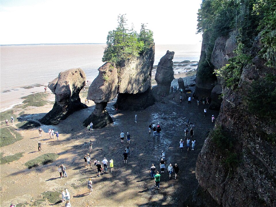
Why it matters. Tides decide when large ships can enter river ports such as Kolkata, and they flush silt from estuaries. Tide tables are essential for fishing, coastal construction and predicting how high a cyclone storm surge will reach.
Tidal energy and what drives currents
The rise and fall of tides can be turned into electricity by trapping water behind a barrage at high tide and releasing it through turbines at low tide. This needs a large tidal range and a suitable bay. In India, the best sites are the Gulf of Khambhat and the Gulf of Kachchh in Gujarat and the Sundarbans in West Bengal, though high costs and ecological concerns have so far held back large projects.
Ocean currents are large, steady flows of water in a definite direction, like rivers within the sea. They are set in motion mainly by winds dragging the surface water, by heating at the equator, which makes water expand and stand slightly higher, and by gravity, which pulls water down the resulting slope. Differences in density drive slower, deeper currents.
As soon as water moves, the Earth's rotation deflects it. This Coriolis force turns currents to the right in the northern hemisphere and to the left in the southern, and it is zero at the equator. The same force steers winds, as explained in three forces that steer the wind.
Driven by the trade winds near the equator and the westerlies in the middle latitudes, and turned by the Coriolis force and the shapes of the continents, surface currents form huge circular loops called gyres. Gyres turn clockwise in the northern hemisphere and anticlockwise in the southern. Floating plastic collects in the calm centres of these gyres, forming "garbage patches".
Why it matters. Currents carry heat, nutrients, larvae and pollution across oceans. Understanding their forces is needed for weather forecasting, search and rescue, and tracking oil spills.
The major currents of the world
A simple pattern helps you remember most currents. Near the equator, trade winds push water westward as the North and South Equatorial Currents. When this warm water reaches the eastern coasts of the continents, it turns poleward, so warm currents flow along east coasts in low and middle latitudes, while cold currents flow towards the equator along west coasts.
In the North Atlantic, the warm Gulf Stream flows north along the east coast of the USA and continues across the ocean as the North Atlantic Drift, warming north-western Europe. The cold Canary Current flows south along north-west Africa, and the cold Labrador Current comes down from the Arctic past Canada. In the North Pacific, the warm Kuroshio flows past Japan, the cold Oyashio comes down from the north, and the cold California Current flows along the west coast of North America.
In the South Atlantic, the warm Brazil Current flows south along South America and the cold Benguela Current flows north along south-west Africa. In the South Pacific, the cold Peru or Humboldt Current flows north along the coast of Peru and Chile. In the Indian Ocean, the warm Agulhas Current flows south along the east coast of Africa and the cold West Australian Current flows north along Australia.
Around Antarctica, with no continents to block it, the Antarctic Circumpolar Current or West Wind Drift flows eastward all the way round the globe, driven by the strong westerlies. It carries more water than any other current.
The northern Indian Ocean is special, because its currents reverse with the monsoon. In summer, the south-west monsoon winds drive a broadly clockwise flow, with the strong Somali Current flowing north along East Africa and upwelling cold water there. In winter, the north-east monsoon reverses the flow to anticlockwise.
Inside this loop of the North Atlantic lies the Sargasso Sea, the only sea in the world with no land boundary. Its edges are drawn by currents alone: the Gulf Stream on the west, the North Atlantic Current on the north, the Canary Current on the east and the North Equatorial Current on the south. Because the currents shift with the seasons, its borders shift too.
The sea is named after Sargassum, a brown seaweed that floats on the open ocean and grows there without ever touching the sea floor. Its floating mats act as nurseries for young turtles and shelter crabs, shrimp and fish. The Sargasso Sea is also a spawning ground for eels, and tuna, birds and humpback whales pass through it.
Why it matters. Currents explain why London is milder than places at the same latitude in Canada, and why some west coasts are deserts. Shipping routes have long followed favourable currents to save time and fuel.
How currents shape climate, fishing and deserts
Warm currents warm the air above them and add moisture, giving mild, wet climates to nearby coasts. The North Atlantic Drift keeps Norway's ports free of ice in winter, far north of the Arctic Circle. Cold currents do the opposite: they cool the air and make it stable, so rain rarely forms.
That is why several of the world's driest deserts lie on west coasts beside cold currents: the Atacama beside the Peru Current, the Namib beside the Benguela Current, and the Atlantic edge of the Sahara beside the Canary Current. Moist sea air chilled over the cold water often forms coastal fog, but little rain.
Where a warm and a cold current meet, the contrast creates thick fog, as off Newfoundland, where the Gulf Stream meets the Labrador Current, and off Japan, where the Kuroshio meets the Oyashio. These meeting zones, along with areas of upwelling, mix nutrients into sunlit water and support some of the richest fishing grounds on Earth, such as the Grand Banks.
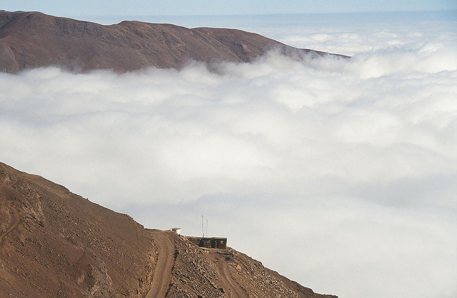
Cold currents with upwelling, like the Peru Current, bring nutrient-rich deep water to the surface and support huge fisheries. When this upwelling weakens during El Niño, fish catches collapse, a link explored in El Niño and the Southern Oscillation.
Why it matters. Ocean currents link the ocean with weather, food supply and the economy of whole countries. Changes in currents with climate change could shift rainfall, fisheries and sea levels along coasts.
Mains lens: what, why, where and so what
This chapter supports GS Paper I (oceanography and world climate) and links to energy, fisheries and disasters in GS Paper III. Here are four angles.
1. Tides and their uses. Answers can explain spring and neap tides and connect them to ports, tidal energy and storm surges in India.
2. Pattern of currents. The east-coast warm, west-coast cold rule, explained through trade winds, gyres and the Coriolis force, is a strong base for any currents answer.
3. Currents and climate. Currents explain mild Western Europe, coastal deserts and fog, which links oceans to world climatic regions.
4. Currents and the economy. Upwelling and the meeting of currents create fishing grounds, and the monsoon reversal of Indian Ocean currents affects India's fisheries and shipping.
Mains lens: practice questions and answer plans
Now turn this understanding into written answers. The four questions below are written in the UPSC style, but they are our own practice questions, not previous-year questions. The real previous-year questions of your exam appear in the "Previous year questions" box once we have matched them with the official papers.
Q1. "What causes tides? Distinguish between spring and neap tides and explain the importance of tides." (250 words)
- Introduction: Define tides and tidal range.
- Body: Moon and Sun, two bulges, spring and neap positions, coastal shape.
- Conclusion: Ports, tidal energy, storm surges.
Q2. "Explain the factors responsible for the origin of ocean currents and the general pattern of their circulation." (250 words)
- Cover wind, heating, gravity, density and the Coriolis force.
- Describe gyres and the east-coast warm, west-coast cold rule.
Q3. "How do ocean currents influence the climate and economy of coastal regions? Give examples." (150 words)
- Cover mild climates, coastal deserts and fog.
- End with fishing grounds.
Q4. "Why do the currents of the northern Indian Ocean reverse seasonally?" (150 words)
- Link the reversal to monsoon winds.
- Mention the Somali Current and upwelling.
Useful keywords: crest, trough, wavelength, fetch, swell, breaker, tidal range, spring tide, neap tide, perigee, tidal bore, tidal energy, Coriolis force, gyre, equatorial currents, Gulf Stream, North Atlantic Drift, Kuroshio, Oyashio, Labrador, Canary, Peru (Humboldt), Benguela, Agulhas, West Wind Drift, upwelling, Grand Banks, Somali Current.
Quick revision
- Waves = moving energy; particles move in circles. Size depends on wind speed, duration and fetch; swells travel far; tsunamis come from sea-floor movement.
- Tides: mainly the Moon; Sun's force a little under half. Two bulges → two highs a day, about 12 h 25 min apart.
- Spring tides: new and full moon (in line). Neap tides: first and last quarter (right angles).
- Highest tides: Bay of Fundy (Canada). Tidal energy sites: Gulfs of Khambhat and Kachchh, Sundarbans.
- Currents: wind, heating, gravity, density; Coriolis right in the north, left in the south. Gyres: clockwise north, anticlockwise south.
- Warm on east coasts, cold on west coasts (low and middle latitudes).
- Warm: Gulf Stream, Kuroshio, Brazil, Agulhas. Cold: Labrador, Oyashio, Canary, California, Peru, Benguela, West Australian. West Wind Drift is the largest.
- Sargasso Sea: only sea with no land boundary, inside the North Atlantic gyre; floating Sargassum seaweed; eel spawning ground.
- North Indian Ocean currents reverse with the monsoon. Meeting of currents → fog and fishing grounds; cold currents → coastal deserts.
HPSC HCS questions from this chapter
Which of the following characteristics are correct about waves? 1. Wind causes waves to travel in the ocean. 2. The actual motion of water beneath the wave is not circular. 3. Steep waves are not fairly young ones and are probably formed by local winds. 4. The highest and lowest points of a wave are called the crest and trough respectively.
- (a) 1 and 2
- (b) 2 and 3
- (c) 3 and 4
- (d) 1 and 4
Show answer
(d) 1 and 4 · our answer; official key awaited