

KPSC KAS · Module 18 · Mains depth · 14 min
World biomes and the forest belts
What KPSC KAS asks from this chapter
Syllabus lines this chapter covers:
- Paper I: General Studies · World and Indian geography with focus on Karnataka.
- GS 2 · Physical features and natural resources of India and Karnataka.
2 KPSC KAS questions in our bank come from this module (World climates, biomes and soils).
Read at full depth: basics, the standard layer and the Mains analysis.
Start from zero: what is a biome?
If you travel from the equator to the North Pole, the plants and animals change in a clear order. First come dense, dripping rainforests, then grasslands with scattered trees, hot deserts, evergreen shrubs, broad-leaved forests, dark conifer forests and finally treeless tundra. Each of these great zones of life is a biome.
A biome is a large community of plants and animals that covers a major region and has a similar look and way of life wherever it occurs. The tropical rainforests of Brazil, the Congo and Indonesia, for example, are thousands of kilometres apart, yet they share tall evergreen trees, climbing plants and an enormous variety of animals.
The main control on biomes is climate, especially temperature and rainfall, which is why biome maps look much like climate maps. Soil, relief and human activity add local variation. The major biomes are forest, grassland, desert, aquatic and high-altitude biomes, and the forest biome itself contains several distinct types.
Why it matters. Biomes decide what people can grow, hunt, harvest and build with in each region. They also hold most of the world's biodiversity and carbon stores.
Tropical evergreen rainforests
Tropical rainforests grow within about 10° north and south of the equator, where it is hot and wet all year. Temperatures stay around 25–30 °C with little seasonal change, and rainfall usually exceeds 200 cm, falling in heavy afternoon showers. There is no dry season, so trees never need to shed all their leaves at once and the forest stays green all year.
The largest rainforests are in the Amazon basin of South America, the Congo basin of Africa and South-East Asia, especially Indonesia and Malaysia. Smaller patches occur in places such as the Western Ghats and the north-east of India.
The forest has several layers. A few giant emergent trees rise above a dense canopy, which forms a nearly closed roof 30 to 45 metres high, and below it are smaller trees, shrubs and a dark forest floor. Climbing plants called lianas and plants that grow on other plants, called epiphytes, compete for light, and the forest has the highest biodiversity of any land biome.
Surprisingly, rainforest soils are poor. Heavy rain washes nutrients down out of reach, a process called leaching, and most nutrients are held in the living plants. Fallen leaves decompose within weeks in the heat and moisture, and roots absorb the nutrients almost at once.
People have lived in rainforests for thousands of years by hunting, gathering and shifting cultivation, clearing a small plot by slash-and-burn, farming it for a few years and moving on when the soil is exhausted. This practice has many local names, such as jhum in north-eastern India, milpa in Central America, ladang in Malaysia and Indonesia, and roca in Brazil. Since colonial times, cleared rainforest land has also been used for plantations of rubber, cocoa, coffee, bananas and oil palm.
Why it matters. Poor soils explain why cleared rainforest gives good crops for only a few years. This drives shifting cultivation and makes deforestation very hard to reverse.
Tropical deciduous and Mediterranean forests
Away from the equator, rainfall becomes seasonal. In regions with a long dry season, such as much of India, northern Australia, Myanmar and parts of Africa and South America, the forests are tropical deciduous or monsoon forests. Trees shed their leaves during the dry season to reduce water loss and grow new leaves when the rains return.
These forests are less dense than rainforests and have fewer layers, so more light reaches the ground. They contain valuable timber trees such as teak and sal, along with bamboo, and they support large animals such as elephants, tigers and deer. Because they are easier to clear and the land is often fertile, much of this forest has been converted to farmland over centuries.
On the western margins of continents between about 30° and 40° latitude, the Mediterranean climate produces a very different forest. Summers are hot and dry, so trees and shrubs are evergreen but have thick, waxy, leathery or small leaves, called sclerophyllous leaves, along with thick bark and deep roots to survive drought. Typical plants include cork oak, olive, eucalyptus in Australia and aromatic shrubs such as lavender and rosemary.
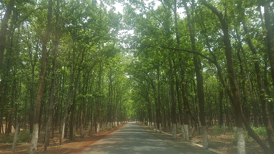
Much of the original Mediterranean forest has been cleared over thousands of years for farming and grazing, leaving scrub vegetation called maquis in Europe and chaparral in California. These regions are also prone to wildfires in the dry summer.
Why it matters. The adaptations of these forests show how plants respond to seasonal drought. The Mediterranean lands also became the world's major producers of citrus fruits, grapes and olives.
Temperate deciduous forests and the taiga
In the mid-latitudes, with warm summers, cold winters and rain in all seasons, grow the temperate deciduous forests. They are found in western and central Europe, the eastern United States and eastern China, Korea and Japan. Broad-leaved trees such as oak, beech, maple, ash and elm shed their leaves in autumn, when cold and frozen ground make water hard to absorb, and grow them again in spring.
These forests once covered huge areas, but most were cleared long ago for farms, towns and industry, especially in Europe. The fertile brown forest soils they left behind became some of the world's most productive farmland.
Further north, between about 50° and 70° north, lies the boreal coniferous forest or taiga, the largest forest belt on Earth. It stretches across Canada, Alaska, Scandinavia and Siberia, where winters are long and very cold and summers short and cool. It is found only in the Northern Hemisphere, because the Southern Hemisphere has little land at these latitudes.
Taiga trees, such as pine, spruce, fir and larch, are cone-shaped so that snow slides off, and they have needle-like leaves with a waxy coating that reduce water loss in winter, when soil water is frozen. Being evergreen, most can begin photosynthesis as soon as spring arrives. The taiga is the world's main source of softwood, used for timber, pulp and paper, while tropical forests supply hardwoods such as mahogany, ebony and rosewood.
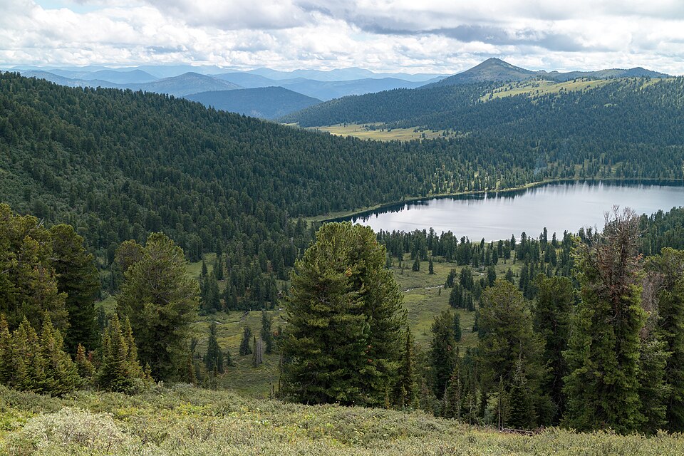
Human population in the taiga is thin, because the soils are acidic and poor and the growing season is too short for most crops. The main activities are lumbering, pulp and paper making, fur trapping and, increasingly, mining of oil, gas and metals, as in Siberia and Canada. Rivers that freeze in winter are used to float logs to sawmills in spring, and cheap hydroelectric power supports the paper industry.
Why it matters. The taiga stores vast amounts of carbon in its trees and peat soils. Forest fires and warming here affect the global climate.
Mountains: biomes stacked by height
Temperature falls by about 6.5 °C for every kilometre of height. So climbing a high mountain is a little like travelling towards the poles, and the vegetation changes in belts stacked one above another. This vertical pattern is called altitudinal zonation.
On the slopes of the Himalaya, for example, the foothills carry tropical and subtropical forests with sal and bamboo. Higher up come temperate forests of oak, chestnut and deodar, then coniferous forests of pine, fir, spruce and birch. Above the tree line, at around 3,500 to 4,000 metres, trees give way to alpine meadows of grasses and flowers, used by herders as summer pastures.
Still higher, only mosses and lichens survive among the rocks, and finally there is permanent snow and ice. The same sequence appears on mountains such as Kilimanjaro in Africa and the Andes in South America, though the heights of each belt vary with latitude and rainfall.
Slope direction matters too. In the Northern Hemisphere, south-facing slopes receive more sunlight and are warmer and drier, while north-facing slopes are cooler and moister, so forest belts often reach different heights on the two sides of a valley.
Why it matters. Mountain vegetation belts support herding, forestry and tourism. They are also very sensitive to warming, as belts shift upward and alpine species run out of space.
Forests under pressure
Forests once covered much more of the Earth than they do today. Temperate forests were cleared over centuries for farming and settlement, and in recent decades the fastest loss has been in the tropics. Large areas of the Amazon, Congo and South-East Asian rainforests are being cleared for logging, cattle ranching, soybean farms, oil palm plantations, mining, roads and dams.
Deforestation has serious effects. It destroys habitats and pushes species towards extinction, since rainforests hold more than half of all land species. It also threatens indigenous peoples who depend on the forest for food, medicine and culture.
Cutting and burning forests releases stored carbon into the air, adding to global warming, and removes a natural carbon sink. Loss of tree cover also increases soil erosion, floods and local drying, because forests recycle a large part of the rain that falls on them through transpiration.
Responses include protected areas, recognising the land rights of forest peoples, certification of sustainable timber and palm oil, reforestation and international payments to reduce emissions from deforestation and forest degradation. The challenge is to balance the economic needs of forest countries with global environmental interests.
Why it matters. Tropical deforestation links biodiversity loss, climate change and the rights of forest communities. It is a recurring issue in international negotiations.
Mains lens: what, why, where and so what
This chapter supports GS Paper I (distribution of key natural resources, world physical geography, changes in flora and fauna) and links to GS Paper III (environment, conservation). Here are four angles.
1. Climate control. Each forest type matches a temperature and rainfall pattern.
2. Adaptations. Leaf shape, leaf fall, bark and roots explain how trees survive.
3. Resources. Hardwood, softwood, plantations and their location.
4. Threats. Deforestation and its links with climate, biodiversity and people.
Mains lens: practice questions and answer plans
Now turn this understanding into written answers. The four questions below are written in the UPSC style, but they are our own practice questions, not previous-year questions. The real previous-year questions of your exam appear in the "Previous year questions" box once we have matched them with the official papers.
Q1. "Why do tropical rainforests have rich vegetation but poor soils?" (150 words)
- Explain climate, layers and biodiversity.
- Explain leaching and fast nutrient cycling.
Q2. "Compare the taiga with the tropical rainforest in terms of climate, vegetation and economic use." (250 words)
- Introduction: Location of both.
- Body: Climate, tree types, adaptations, softwood versus hardwood.
- Conclusion: Their global carbon role.
Q3. "Explain how plants of the Mediterranean region are adapted to their climate." (150 words)
- Describe dry summers and wet winters.
- Give leaf, bark and root adaptations with examples.
Q4. "Examine the causes and consequences of tropical deforestation." (250 words)
- Cover logging, ranching, plantations and mining.
- Cover biodiversity, climate, soils and people; suggest responses.
Useful keywords: biome, rainforest, canopy, emergent, liana, epiphyte, leaching, nutrient cycling, monsoon forest, teak, sal, Mediterranean, sclerophyllous leaves, maquis, chaparral, temperate deciduous, taiga, conifer, needle leaves, softwood, hardwood, altitudinal zonation, tree line, alpine meadow, deforestation, oil palm, carbon sink, indigenous peoples.
Quick revision
- Biome = large plant–animal community shaped mainly by climate; five major biomes: forest, grassland, desert, aquatic, high-altitude.
- Tropical rainforest: about 10° N–S, rain all year, layered canopy, highest biodiversity, poor leached soils; Amazon, Congo, South-East Asia.
- Tropical deciduous (monsoon): leaves shed in dry season; teak, sal.
- Mediterranean: evergreen, thick waxy or small leaves; cork oak, olive; maquis, chaparral.
- Temperate deciduous: oak, beech, maple; western Europe, eastern USA, eastern Asia.
- Taiga: about 50°–70° N, Northern Hemisphere only; pine, spruce, fir, larch; softwood.
- Mountains: altitudinal zonation; tree line about 3,500–4,000 m in the Himalaya.
- Deforestation drivers: logging, ranching, soybean, oil palm, mining.