

MPPSC State Forest Service · Module 14 · standard depth · 14 min
Soils of India
What MPPSC State Forest Service asks from this chapter
Syllabus lines this chapter covers:
- Prelims Paper I: General Studies (shared with the State Service Exam) · Geography of India and Madhya Pradesh
- Mains Paper I: Section A General Studies (Madhya Pradesh) and Section B Forestry and General Science · Environment: biodiversity and conservation, pollution, solid waste, disaster management, population and environment, environment and health
MPPSC State Forest Service questions from this module are being sorted into our bank.
Cut to standard depth for MPPSC State Forest Service. 11 deeper paragraphs are in the full chapter.
Start from zero: what is soil?
Pick up a handful of earth from a field. It looks like simple dust, but it is a living mixture. It contains tiny pieces of broken rock, dark remains of dead plants and animals called humus, water, air and billions of small living things.
Soil starts as solid rock. Heat, cold, rain and roots slowly crack the rock into smaller pieces, a process called weathering. Plants then grow, die and rot, adding humus, while worms and microbes mix everything together.
This process is extremely slow. A few centimetres of fertile soil can take hundreds of years to form, but a single heavy storm can wash it away. That is why geographers call soil a resource that is renewable only over very long periods.
What kind of soil forms in a place depends on five main factors. These are the parent rock it comes from, the climate (heat and rain), the relief or slope of the land, the plants and animals living there, and time.
Why it matters. Nearly all our food grows in soil, and India must feed a very large population on limited land. Knowing which soil lies where explains why Punjab grows wheat, why Maharashtra grows cotton and why Kerala grows cashew. It also explains why losing soil to erosion or salt is a direct threat to food security.
Reading a soil: profiles and the eight soil groups
If you dig a deep pit, you will see that soil is not the same from top to bottom. It is arranged in layers called horizons, and the full vertical cut is called the soil profile. Each horizon tells part of the soil's story.
The top A horizon is dark and rich in humus, and most plant roots live here. Below it is the B horizon, where minerals washed down by rainwater from above collect. The C horizon at the bottom is made of weathered pieces of the parent rock, which rest on solid bedrock.
Soils across India differ a great deal in colour, texture and fertility. To make sense of this variety, the Indian Council of Agricultural Research (ICAR) groups Indian soils into eight major types. They are alluvial, black, red and yellow, laterite, arid, saline, peaty and forest soils.
Each group is linked to a particular combination of rock, climate and relief. Alluvial soils follow the rivers, black soils follow the lava rocks of the Deccan, laterite soils follow heavy rain and heat, and arid soils follow the desert. Once you learn these links, the soil map of India becomes easy to remember.
Why it matters. A soil profile tells farmers how deep roots can grow and how well the soil holds water. The classification helps governments match crops, fertilisers and irrigation to each region. It is also the base for soil testing, which tells a farmer which nutrients are missing.
Alluvial soils: gifts of the rivers
The most widespread soils of India are the alluvial soils, which cover about 40% of the country. They are made of fine material, called alluvium, that rivers carry down from the mountains and spread over their plains. The Indus, Ganga and Brahmaputra systems have built the great northern plains this way, and the rivers of the peninsula have built their deltas on the eastern coast.
Alluvial soils are not all alike. Near the rivers, floods spread fresh silt almost every year, so the soil stays young and fertile; this newer alluvium is called khadar. Farther from the river, on slightly higher ground that floods rarely reach, lies older alluvium called bhangar, which often contains lumps of lime called kankar.
In texture, alluvial soils range from sandy to clayey, and they are usually light grey to ash in colour. In nutrients, they are generally rich in potash but poor in phosphorus. With good irrigation and fertilisers, they are among the most productive soils in the world.
These soils support rice, wheat, sugarcane, pulses, oilseeds and jute. Their fertility, along with flat land and river water, is why the northern plains became the most densely populated farming region of India and one of the oldest homes of civilisation.
Why it matters. The alluvial plains are India's food bowl, but they face new pressures. Heavy use of irrigation, fertilisers and groundwater has reduced soil health in parts of the north-west. At the same time, floods that bring fresh silt also destroy crops and homes, which makes the plains both rich and risky.
Black, red and yellow soils of the plateau
Travel south into the Deccan and the colour of the fields changes. Over much of Maharashtra and parts of Gujarat, Madhya Pradesh, Andhra Pradesh, Telangana, Karnataka and Tamil Nadu, the soil is deep black. This black soil, also called regur or black cotton soil, formed mainly from the lava rocks of the Deccan, which poured out of the Earth millions of years ago.
Black soil is fine and clayey, so it holds moisture for a long time, which suits crops grown without much irrigation. When wet, it swells and becomes sticky; when dry, it shrinks and develops deep cracks. Air enters through these cracks, so farmers say the soil "ploughs itself".
Black soil is rich in lime, iron, magnesia and potash but poor in phosphorus, nitrogen and organic matter. It is the classic soil for cotton, which is why it is called black cotton soil, and it also supports jowar, wheat, sugarcane, oilseeds and pulses.
To the east and south of the black soil belt, on old crystalline rocks such as granite and gneiss, lies red soil. It develops where rainfall is relatively low, across much of Tamil Nadu, Karnataka, Andhra Pradesh, Telangana, Odisha and Chhattisgarh. Its red colour comes from iron oxide spread through it, and where the iron is hydrated the soil looks yellow, which is why the group is called red and yellow soil.
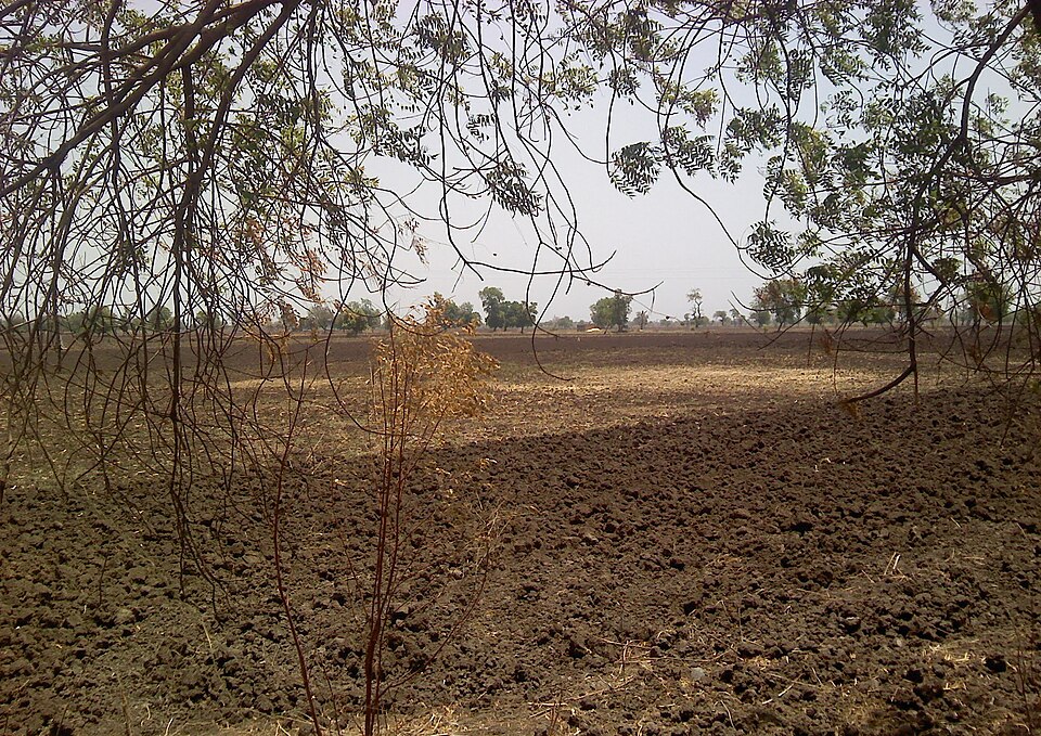
Red soils are usually light, porous and less fertile, because they are poor in nitrogen, phosphorus and humus. With fertilisers and irrigation, they grow millets, pulses, groundnut, tobacco and potatoes.
Why it matters. The Deccan's soils shape its farm economy. Cotton in the black soil belt supports a large textile industry, but rain-fed cotton is risky in drought years, which links soils to farm distress. Red soils need careful nutrient management, so soil testing and balanced fertiliser use make a big difference there.
Laterite, arid, saline, peaty and forest soils
Laterite soil forms where both temperature and rainfall are high. Heavy rain washes the soluble nutrients deep down and away, a process called leaching, leaving behind iron and aluminium. That is why laterite is rich in iron and aluminium but poor in nitrogen, potash and organic matter.
The name comes from the Latin word "later", meaning brick, because the soil hardens when exposed to air and can be cut into bricks. Laterite is found in Karnataka, Kerala, Tamil Nadu, Madhya Pradesh and the hilly areas of Odisha and Assam. With manure and fertilisers, it grows tea, coffee and especially cashew.
In western Rajasthan, the arid soils are sandy, red to brown, low in humus and often salty. Below the surface, a layer of kankar blocks water from sinking deeper. With irrigation, as along the Indira Gandhi Canal, these soils can grow crops, but they easily turn salty if water drains poorly.
Saline soils, also called usara, contain too much salt and are infertile. They occur naturally in western Gujarat, the deltas of the eastern coast and the Sundarbans. They have also been created by people: over-irrigation in parts of Punjab and Haryana has brought salt up to the surface, and adding gypsum is one way to reclaim such land.
Peaty soils form in areas of heavy rain and high humidity, where dead plants pile up faster than they rot. They are rich in organic matter and are found in northern Bihar, southern Uttarakhand and the coastal areas of West Bengal, Odisha and Tamil Nadu. Finally, forest soils develop on forested hills; they are acidic and low in humus at high altitudes but more fertile in the lower valleys.
Why it matters. These soils show how climate and human use change land. Heavy rain makes laterite poor, dry heat makes arid soils thin, and careless irrigation can turn good land salty. Reclaiming saline and degraded land is cheaper than finding new farmland, so these soils are a quiet but important part of India's food policy.
Soil erosion and conservation
Soil is lost when the top layer is carried away faster than new soil can form. This is soil erosion, and its two main agents are running water and wind. Cutting forests, overgrazing, ploughing up and down slopes and leaving fields bare all speed it up.
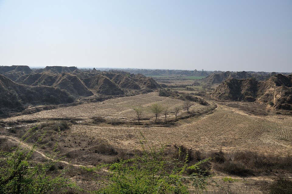
Running water first removes thin sheets of soil from a whole field, which is hard to notice. As water collects into channels, it cuts deeper gullies, and in time the land becomes a maze of ravines that cannot be farmed. The Chambal valley is the best-known example of such badlands in India.
In dry regions such as western Rajasthan, wind is the main agent. It blows away loose, dry topsoil and spreads sand over farmland. Over time, this can turn productive land into desert-like conditions.
Soil can be protected in many simple ways. On gentle slopes, farmers plough along the contours instead of up and down, so that each furrow stops water. On steep hills, terraces cut into the slope turn it into a series of flat steps, as on the hills of Uttarakhand and the north-east.
Other methods include strip cropping, where strips of grass are grown between crops to break the force of wind and water, and shelter belts, which are rows of trees planted to slow the wind. Controlling overgrazing, planting trees on bare slopes and building small check dams across gullies also keep soil in place.
Why it matters. Losing topsoil means losing the most fertile part of the land, and it also fills reservoirs with silt and shortens the life of dams. Soil conservation is therefore part of watershed development, drought-proofing and dam safety. Healthy soils also store more water and carbon, which helps in adapting to a changing climate.
Quick revision
- Soil is made of rock particles, humus, water and air, and it forms very slowly from parent rock, climate, relief, organisms and time.
- ICAR groups Indian soils into eight types: alluvial, black, red and yellow, laterite, arid, saline, peaty and forest.
- Alluvial soils cover about 40% of India; new alluvium is khadar, old alluvium with kankar is bhangar, and they are rich in potash but poor in phosphorus.
- Black soil (regur) comes from Deccan lava, holds moisture, cracks when dry, is rich in lime, iron, magnesia and potash, and suits cotton.
- Red soil is red from iron oxide on old crystalline rocks in drier areas, and turns yellow when the iron is hydrated.
- Laterite forms by leaching under heavy rain and heat, is rich in iron and aluminium, takes its name from Latin "later" (brick) and suits cashew.
- Saline (usara) soils occur in western Gujarat, deltas and the Sundarbans, and over-irrigation has made parts of Punjab and Haryana saline; gypsum helps reclaim them.
- Erosion by water and wind is checked by contour ploughing, terracing, strip cropping, shelter belts and check dams, and the Chambal ravines are India's classic badlands.