

MPPSC SSE (State Service) · Module 22 · Mains depth · 14 min
Asia: mountains, plateaus, rivers and climate
What MPPSC SSE (State Service) asks from this chapter
MPPSC SSE (State Service) has asked 2 questions from this chapter (2021, 2017); 7 from its whole module.
Read at full depth: basics, the standard layer and the Mains analysis.
Start from zero: the giant continent
Look at a globe and Asia fills almost a third of the land. It stretches from the Mediterranean and the Red Sea in the west to the Pacific Ocean in the east, and from the frozen Arctic coast in the north to the equatorial islands of Indonesia in the south. It is the largest continent, covering about 30 per cent of the world's land area.
Asia is joined to Europe along a long land boundary, usually drawn along the Ural Mountains, the Ural River, the Caspian Sea and the Caucasus. Together they form the landmass of Eurasia. In the south-west, the narrow Isthmus of Suez links Asia with Africa.
Asia is also the most populous continent, home to about 60 per cent of humanity. China and India alone hold more than a third of the world's people, and the fertile river valleys of Asia, along the Huang He, Indus, Ganga and Tigris–Euphrates, cradled some of the earliest civilisations.
Because of its size, Asia contains the greatest contrasts on Earth: the highest mountains and the lowest land, the wettest and some of the coldest inhabited places, vast deserts and dense rainforests. Learning Asia's map is the key to understanding India's neighbourhood.
Why it matters. India's security, trade, water and climate are tied to Asian geography. Map questions on Asian mountains, rivers and seas appear regularly in Prelims.
The mountain heart of Asia
At the centre of Asia's mountains lies the Pamir Knot, a high mountain mass where Tajikistan, Afghanistan, China and Pakistan meet. It is called the "roof of the world". From it, great ranges radiate like the arms of a starfish.
To the south-west runs the Hindu Kush into Afghanistan. To the east run the Karakoram, home of K2, the second-highest peak, and the Kunlun along the northern edge of Tibet. To the north-east runs the Tien Shan into Central Asia, and the Himalaya curve south-east from the Karakoram region along India's northern border.
These ranges are young fold mountains, raised by the collision of the Indian plate with the Eurasian plate. Further west, the Zagros and Elburz mountains of Iran and the Taurus and Pontic ranges of Turkey continue this belt, while the Altai, Sayan and other ranges rise in the north towards Mongolia and Siberia.
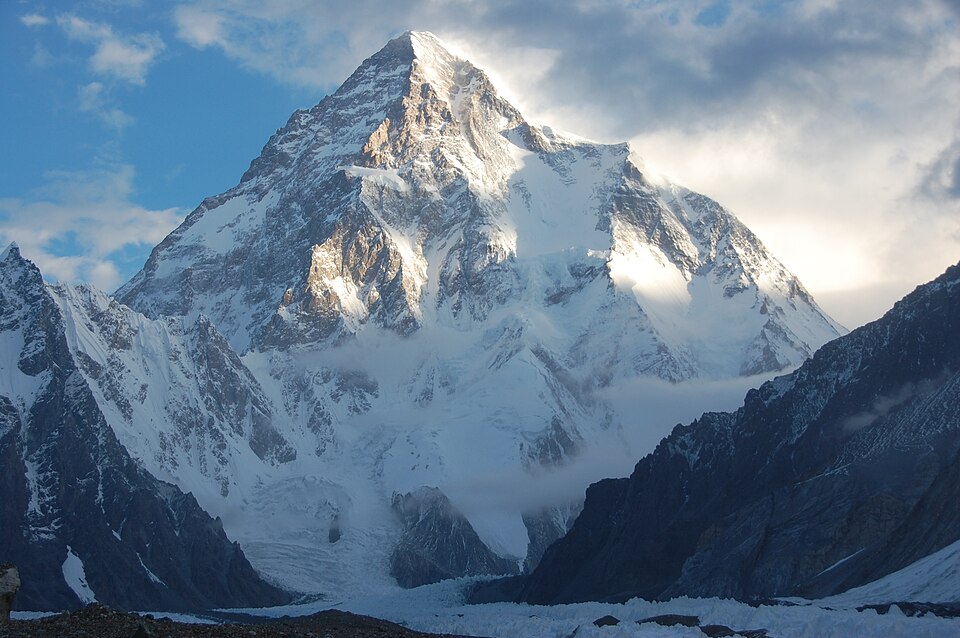
The Himalaya contain the world's highest peak, Mount Everest at 8,849 metres, on the Nepal–China border. In contrast, the shore of the Dead Sea, between Jordan and Israel, lies about 430 metres below sea level, the lowest point on land.
Why it matters. These mountains shape Asia's climate, rivers and political boundaries. Passes through them have carried trade, armies and ideas for thousands of years.
Plateaus, plains and deserts
Between and beyond the mountains lie vast plateaus. The Tibetan Plateau, averaging more than 4,000 metres, is the highest and largest plateau in the world and is the source of many great rivers. Other major plateaus include the Deccan of India, the Anatolian plateau of Turkey, the Iranian plateau, the Mongolian plateau and the Arabian plateau, which tilts gently towards the Persian Gulf.
Asia's great plains are mostly river plains. The West Siberian Plain, drained by the Ob, is one of the largest and flattest lowlands on Earth, with huge marshes. The Indo-Gangetic plain of South Asia, the North China Plain of the Huang He and the Mesopotamian plain of the Tigris and Euphrates are fertile and densely populated.
Asia also has huge deserts. The Gobi of Mongolia and China and the Taklamakan in the Tarim basin are cold, mid-latitude deserts surrounded by mountains. The Rub al Khali, or Empty Quarter, in southern Arabia is one of the largest sand deserts in the world, while the Thar lies in India and Pakistan and the Karakum and Kyzylkum lie in Central Asia.
The pattern makes sense once you see the mountain walls. Moist ocean winds are blocked by the ranges, leaving the interiors of Asia dry, while the plains open to the sea receive monsoon rains.
Why it matters. Asia's fertile plains feed billions, while its plateaus and deserts are sparsely peopled but rich in minerals and energy. The Tibetan Plateau is often called Asia's "water tower".
Rivers and lakes of Asia
Asia's rivers flow outward from the central mountains and plateaus in all directions. The Ob, Yenisei and Lena flow north across Siberia into the Arctic Ocean. They freeze in winter, and in spring their upper courses in the south thaw first while the mouths remain frozen, so water spreads over the land and causes floods.
Rivers flowing east into the Pacific include the Amur, which forms part of the Russia–China border, the Huang He, or Yellow River, and the Yangtze, the longest river in Asia. The Huang He carries so much yellow silt that it raises its own bed and has shifted course many times, causing terrible floods, which is why it is called "China's sorrow". The Yangtze carries the giant Three Gorges Dam.
Rivers flowing south into the Indian Ocean include the Indus, Ganga and Brahmaputra (called the Yarlung Tsangpo in Tibet), the Irrawaddy and Salween of Myanmar, and the Tigris and Euphrates, which join as the Shatt al-Arab before entering the Persian Gulf. The Mekong, rising in Tibet, flows through six countries, China, Myanmar, Laos, Thailand, Cambodia and Vietnam, to the South China Sea.
Some rivers never reach the sea. The Amu Darya and Syr Darya drain into the Aral Sea, which has shrunk dramatically since the 1960s because their waters were diverted to irrigate cotton. The Caspian Sea is the largest lake by area in the world, while Lake Baikal in Siberia is the deepest lake and holds the largest volume of fresh surface water of any single lake.
Because these rivers cross borders, countries have built agreements to share them. The Indus Waters Treaty of 1960, brokered by the World Bank, gave the three eastern rivers, the Ravi, Beas and Sutlej, to India and the three western rivers, the Indus, Jhelum and Chenab, mainly to Pakistan. On the Mekong, the downstream countries work through the Mekong River Commission, while dams built upstream in China raise concerns about water flow and fisheries.
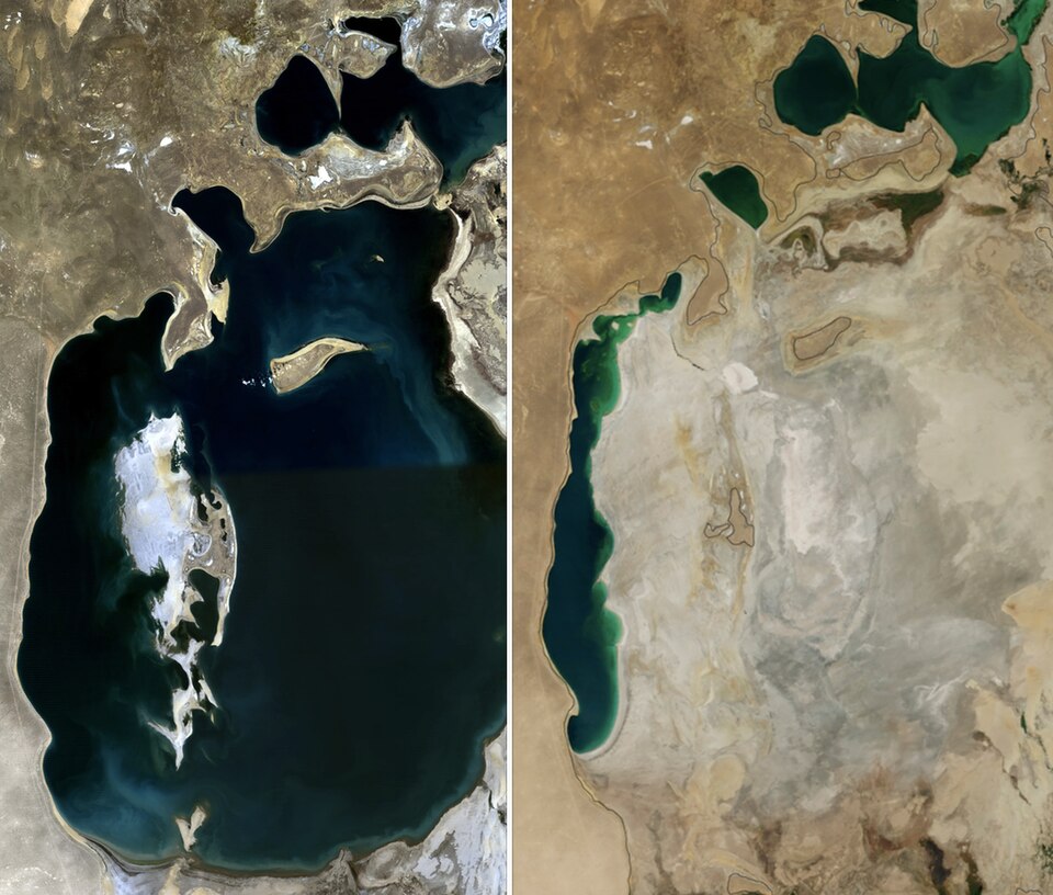
Why it matters. Many of Asia's great rivers cross borders, so sharing their water is a major diplomatic issue. The Aral Sea disaster is a warning about unplanned irrigation.
Climate, islands and the Ring of Fire
Asia stretches from near the equator to beyond the Arctic Circle, so it has every climate type. Indonesia and Malaysia have equatorial climates with rain all year, while northern Siberia has tundra. In between lie monsoon lands, hot deserts, temperate grasslands and vast snow forests.
The monsoon dominates South, South-East and East Asia. In summer, the heated land draws in moist winds from the oceans, bringing heavy rain, and in winter, cold, dry winds blow out from the interior. Places in north-eastern India, such as Mawsynram and Cherrapunji in Meghalaya, are among the wettest on Earth.
The heart of Asia is far from any ocean, so it has an extreme continental climate. North-eastern Siberia has some of the coldest inhabited places on Earth, such as Verkhoyansk and Oymyakon, where winter temperatures have fallen below −65 °C, while summers can be warm.
Along Asia's eastern edge lie chains of island arcs: Japan, the Philippines and Indonesia, the world's largest archipelago country. These lie on the Pacific Ring of Fire, where ocean plates sink beneath others, causing frequent earthquakes, volcanoes and tsunamis, such as the Indian Ocean tsunami of 2004 triggered off Sumatra.
Why it matters. The monsoon decides the food supply of billions of people. The Ring of Fire makes disaster preparedness central to East and South-East Asian planning.
Regions of Asia and why they matter to India
Asia is often divided into regions. South Asia includes India, Pakistan, Bangladesh, Nepal, Bhutan, Sri Lanka, the Maldives and Afghanistan. South-East Asia includes the mainland countries of Myanmar, Thailand, Laos, Cambodia and Vietnam, and the island and peninsular countries of Malaysia, Singapore, Indonesia, the Philippines, Brunei and Timor-Leste.
East Asia includes China, Japan, the two Koreas, Mongolia and Taiwan. Central Asia covers Kazakhstan, Uzbekistan, Turkmenistan, Kyrgyzstan and Tajikistan, landlocked states rich in oil, gas and uranium. West Asia, from Turkey to Iran and the Arabian Peninsula, holds much of the world's oil and is covered in Africa and West Asia.
Several Asian seas and straits are vital trade routes. The Strait of Malacca, between Malaysia and Sumatra, links the Indian Ocean with the South China Sea and carries a large share of world shipping, including much of China's and Japan's oil. The South China Sea is the scene of overlapping territorial claims.
For India, Asian geography shapes key interests: Himalayan rivers shared with China, Nepal, Bhutan, Bangladesh and Pakistan; the Act East policy towards South-East Asia; energy imports from West Asia; and connectivity with Central Asia through Iran and Afghanistan.
Why it matters. Knowing Asia's regions, seas and choke points is essential for international relations and maps in both Prelims and Mains.
Mains lens: what, why, where and so what
This chapter supports GS Paper I (salient features of world physical geography, distribution of resources) and links to GS Paper II (India and its neighbourhood) and GS Paper III (water security, disasters). Here are four angles.
1. Relief. The Pamir Knot, radiating ranges, plateaus and the Tibetan "water tower".
2. Drainage. Arctic, Pacific, Indian Ocean and inland rivers; transboundary water.
3. Climate. Monsoon, continentality and the Ring of Fire.
4. Strategy. Regions, straits and India's interests.
Mains lens: practice questions and answer plans
Now turn this understanding into written answers. The four questions below are written in the UPSC style, but they are our own practice questions, not previous-year questions. The real previous-year questions of your exam appear in the "Previous year questions" box once we have matched them with the official papers.
Q1. "The Tibetan Plateau is called the water tower of Asia. Explain its significance." (150 words)
- Name the rivers rising there.
- Discuss water security and transboundary issues.
Q2. "Why do the Siberian rivers cause floods in spring?" (150 words)
- Explain the northward flow and freezing.
- Explain thawing of upper courses first.
Q3. "The shrinking of the Aral Sea is a man-made disaster. Discuss." (150 words)
- Cover diversion of the Amu Darya and Syr Darya.
- Cover ecological, health and economic effects.
Q4. "Discuss the geographical factors that make Asia the most populous continent." (250 words)
- Introduction: Population share.
- Body: River plains, monsoon, fertile soils, long farming history; sparse interiors.
- Conclusion: Pressures on land and water.
Useful keywords: Eurasia, Pamir Knot, roof of the world, Hindu Kush, Karakoram, Kunlun, Tien Shan, Himalaya, Zagros, Tibetan Plateau, water tower, West Siberian Plain, Indo-Gangetic plain, Gobi, Taklamakan, Rub al Khali, Ob, Yenisei, Lena, Huang He, China's sorrow, Yangtze, Three Gorges, Mekong, Aral Sea, Caspian Sea, Lake Baikal, Dead Sea, monsoon, continentality, Ring of Fire, Strait of Malacca.
Quick revision
- Asia: largest continent (about 30 per cent of land), about 60 per cent of people; Europe boundary along the Urals, Caspian, Caucasus.
- Pamir Knot ("roof of the world"): Hindu Kush, Karakoram (K2), Kunlun, Tien Shan; Himalaya linked.
- Highest: Everest 8,849 m; lowest: Dead Sea shore about −430 m.
- Tibetan Plateau: highest and largest; others: Deccan, Anatolian, Iranian, Mongolian, Arabian.
- Deserts: Gobi, Taklamakan, Rub al Khali, Thar, Karakum, Kyzylkum.
- Arctic rivers: Ob, Yenisei, Lena (spring floods).
- Yangtze longest in Asia; Huang He "China's sorrow"; Mekong six countries.
- Caspian largest lake by area; Baikal deepest; Aral shrunk (Amu Darya, Syr Darya).
- Ring of Fire: Japan, Philippines, Indonesia.
- Strait of Malacca: Indian Ocean to South China Sea.
MPPSC SSE (State Service) questions from this chapter
Why the Aral Sea was called a 'Dying Saline Lake'?
Which of the following countries does not form border with the Caspian Sea?
- (a) Azerbaijan
- (b) Iran
- (c) Iraq
- (d) Kazakhstan
Show answer
(c) Iraq · our answer; official key awaited