

MPSC Rajyaseva · Module 21 · Mains depth · 13 min
Europe: peninsulas, the Gulf Stream and industry
What MPSC Rajyaseva asks from this chapter
Syllabus lines this chapter covers:
- Paper I: General Studies · Maharashtra, India and world geography: physical, social and economic geography.
- GS I · Physical geography of the world, India and Maharashtra; resources and location of industries; geophysical phenomena.
MPSC Rajyaseva questions from this module are being sorted into our bank.
Read at full depth: basics, the standard layer and the Mains analysis.
Start from zero: the peninsula of peninsulas
Europe is not really a separate landmass. It is the western end of the great Eurasian landmass, joined to Asia along a long land border. By convention, the Ural Mountains, the Ural river, the Caspian Sea and the Caucasus mountains are taken as the boundary between the two continents.
Europe is small in area but has a very long, broken coastline. It is made up of peninsulas: the Scandinavian, Iberian (Spain and Portugal), Italian, Balkan and Jutland (Denmark) peninsulas, with islands such as Great Britain, Ireland and Iceland. Almost no part of western Europe is far from the sea.
This closeness to the sea shaped Europe's history. Its seafaring peoples built trading empires, and its many sheltered harbours and navigable rivers carried goods cheaply. When coal and iron fuelled the Industrial Revolution, Europe became the world's first great industrial region.
Why it matters. Europe's shape and climate explain why it industrialised early and still holds dense cities and rich farmland. The European Union is one of India's largest trading partners.
Mountains, plains and fjords
Europe's relief has three broad parts. In the north-west are old, worn-down highlands: the mountains of Scandinavia, Scotland and Ireland. In the middle lies the vast North European Plain, stretching from western France across the Netherlands, Germany and Poland into Russia. In the south rise the young fold mountains of the Alpine system.
The Alpine system includes the Alps, the Pyrenees between France and Spain, the Apennines along Italy, the Dinaric Alps of the Balkans, the Carpathians and the Caucasus. They were pushed up when the African plate moved north against Europe. Mont Blanc is the highest peak of the Alps, while Mount Elbrus in the Caucasus is often counted as Europe's highest peak.
During the Ice Age, great glaciers covered northern Europe. They carved deep U-shaped valleys along the coast of Norway, and when the ice melted the sea flooded them to form fjords, long, narrow, steep-sided inlets. Glaciers also left thousands of lakes in Finland and Sweden and spread fertile and sandy deposits across the northern plain.
The south is geologically active. Mount Etna in Sicily and Vesuvius near Naples are active volcanoes, and earthquakes strike Italy, Greece and Turkey. Iceland sits on the Mid-Atlantic Ridge, where two plates move apart, so it has active volcanoes, hot springs and geysers.
The northern edge of Europe reaches into the Arctic. Northern Scandinavia and Russia have tundra and the vast coniferous taiga forest, which supplies timber, pulp and paper, especially in Sweden, Finland and Russia. The Sami people of the far north have traditionally herded reindeer.
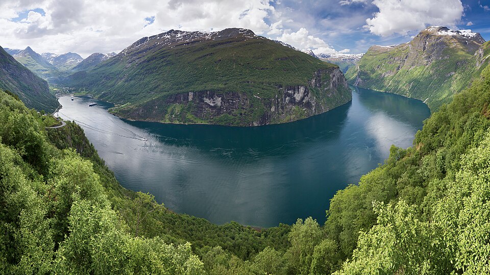
Why it matters. The North European Plain is Europe's farming and population heartland. The Alps supply rivers, hydropower and tourism, and fjords give Norway sheltered deep-water harbours.
The Gulf Stream and Europe's climate
Look at a globe. London lies at about 51° N, roughly the same latitude as the bleak coast of Labrador in Canada. Yet London's winters are mild, while Labrador's are bitterly cold and its sea freezes.
The reason is the Gulf Stream, a warm ocean current from the Gulf of Mexico. It crosses the Atlantic as the North Atlantic Drift and bathes the coasts of Ireland, Britain and Norway with warm water. The westerly winds blow from the ocean onto the land, carrying this warmth and moisture far inland. This is why ports along the Norwegian coast, and even Murmansk in Arctic Russia, stay ice-free in winter.
So western Europe has a marine west coast climate: mild winters, cool summers and rain all year. Moving east, away from the ocean, winters become colder and summers hotter, and the climate becomes continental, as in Poland and Russia. In the south, around the Mediterranean Sea, the climate is Mediterranean, with hot dry summers and mild wet winters, suited to olives, grapes and citrus.
Why it matters. The Gulf Stream lets western Europe farm and live comfortably at high latitudes. Scientists watch whether climate change could weaken this Atlantic circulation, which would sharply cool Europe's winters.
Rivers and waterways
Europe's rivers are shorter than those of Asia, Africa or the Americas, but they are among the most useful in the world. Most flow gently across plains, are fed by steady rain and Alpine snowmelt, and have been linked by canals.
The Volga, the longest river in Europe, flows through Russia and empties into the Caspian Sea, an inland sea with no outlet to the ocean. Canals link it with the Baltic, White, Black and Azov seas, so it is a great inland transport route.
The Danube rises in Germany's Black Forest and flows east through or along about ten countries, including Austria, Hungary, Serbia and Romania, before entering the Black Sea through a large delta. Capitals such as Vienna, Budapest and Belgrade stand on its banks.
The Rhine rises in the Swiss Alps and flows north through Germany and the Netherlands to the North Sea. It is Europe's busiest inland waterway, carrying coal, ore, oil and containers between the Ruhr and the port of Rotterdam. Other important rivers include the Seine through Paris, the Thames through London, and the Elbe, Oder and Vistula across the northern plain.
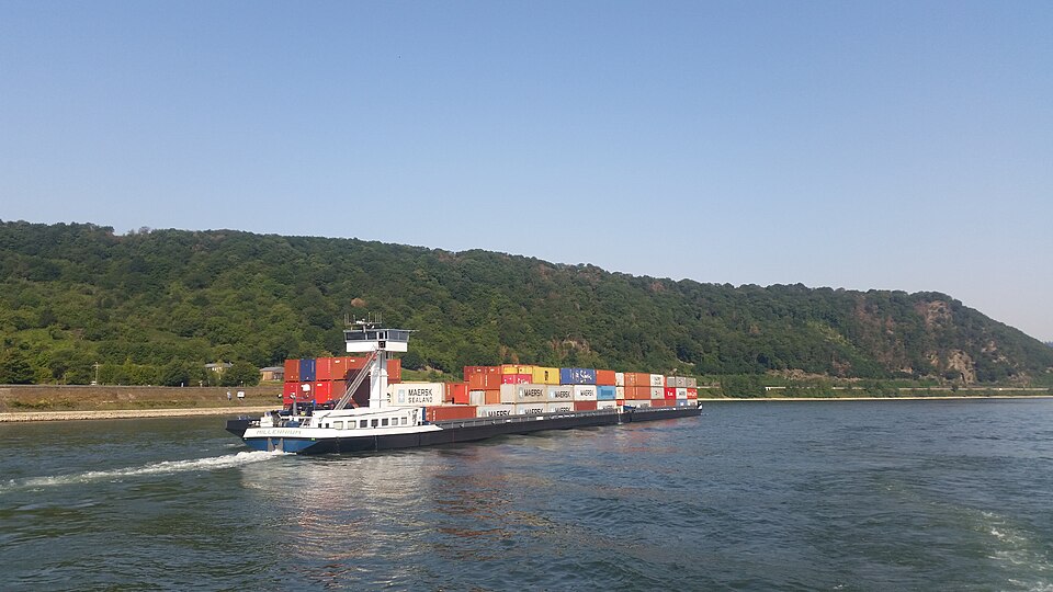
Europe is also ringed by busy seas. The Baltic Sea in the north is shallow and less salty, and it freezes in its northern gulfs in winter. The Mediterranean Sea in the south links with the Atlantic through the narrow Strait of Gibraltar, with the Black Sea through the Dardanelles and Bosporus, and with the Red Sea through the Suez Canal. The English Channel and the North Sea carry some of the heaviest shipping traffic in the world.
Why it matters. Cheap river transport helped Europe industrialise and still moves bulk goods. The Rhine and Danube show how shared rivers can be managed by international agreements.
Resources and industrial regions
Europe's modern industry began on its coalfields. Britain's coalfields in the Midlands, Yorkshire and South Wales powered the first factories. A belt of coal then ran across northern France and Belgium into Germany, where the Ruhr valley grew into one of the world's greatest centres of coal, iron and steel and heavy engineering.
Industry gathered along the Rhine because the river could carry heavy raw materials cheaply. Iron ore came from Lorraine in France and from Sweden (Kiruna), which exported high-grade ore through Narvik in Norway, a port kept ice-free by the North Atlantic Drift. Later, as coal declined, many old industrial regions had to shift to services and high technology.
Since the 1970s, the North Sea has produced oil and natural gas, mainly for the United Kingdom and Norway. Rotterdam, at the mouth of the Rhine, is Europe's largest port and a major oil-refining centre. Russia supplies large amounts of natural gas through pipelines, which became a major political issue after 2022.
Farming is highly productive. The Ukraine and southern Russian steppe, with fertile black chernozem soils, grows huge amounts of wheat, sunflower and maize for export. Western Europe practises intensive mixed farming and dairying, and the Mediterranean grows olives, grapes and citrus.
Why it matters. The Ruhr is the classic example of industry locating on coal and water transport. Black Sea grain and Russian gas show how regional geography affects global food and energy prices.
People and regions of Europe
Europe is one of the most densely populated and urbanised continents. Its population is concentrated on the North European Plain, along the Rhine, around London and Paris, and in northern Italy's Po valley. The cold north of Scandinavia and Russia, and the high mountains, are thinly peopled.
Many European countries have ageing populations and very low birth rates. Their populations would shrink without immigration, and they face a growing burden of pensions and health care. This is the late stage of the demographic transition that India is now moving towards.
Europe is often divided into regions. Western Europe includes Britain, France, the Benelux countries and Germany, the old industrial core. Northern Europe covers Scandinavia, Finland and the Baltic states. Southern Europe covers the Mediterranean peninsulas, and Eastern Europe stretches across Poland, Ukraine and European Russia.
Many European countries have joined together in the European Union, which has removed most trade barriers between members and allows people to move and work freely among many of them. This shows how geography and history have pushed a crowded continent of many nations towards economic integration.
Why it matters. Europe's ageing offers lessons for India's future. Its integration is a model for regional cooperation, and it is a major market for Indian exports and skilled workers.
Mains lens: what, why, where and so what
This chapter supports GS Paper I (world physical geography, ocean currents, location of industries) and links to GS Paper II (India–EU relations) and GS Paper III (energy and food security). Here are four angles.
1. Shape. A peninsula of peninsulas with a long, broken coast.
2. Climate. The Gulf Stream and westerlies make the west mild.
3. Industry. Coal, rivers and ports in the Ruhr–Rhine–Rotterdam axis.
4. Global links. North Sea and Russian energy, Black Sea grain.
Mains lens: practice questions and answer plans
Now turn this understanding into written answers. The four questions below are written in the UPSC style, but they are our own practice questions, not previous-year questions. The real previous-year questions of your exam appear in the "Previous year questions" box once we have matched them with the official papers.
Q1. "Explain why the ports of Norway remain ice-free in winter while those at similar latitudes elsewhere freeze." (150 words)
- Describe the North Atlantic Drift and westerlies.
- Compare with Labrador or the Baltic.
Q2. "Account for the growth of the Ruhr as a major industrial region." (150 words)
- Coal, river transport, ore supply and markets.
- Mention its later restructuring.
Q3. "The rivers of Europe are short but highly useful. Discuss." (250 words)
- Introduction: Name the main rivers and their seas.
- Body: Gentle gradient, steady flow, canals, the Rhine and Rotterdam.
- Conclusion: International river management.
Q4. "How does the geography of the Black Sea region affect global food security?" (150 words)
- Chernozem steppe, wheat exports, ports and straits.
- Effects of disruption on importing countries.
Useful keywords: Eurasia, Urals, Caucasus, Caspian, peninsula of peninsulas, North European Plain, Alpine system, Mont Blanc, Elbrus, fjords, Iceland, Mid-Atlantic Ridge, Etna, Vesuvius, Gulf Stream, North Atlantic Drift, westerlies, Murmansk, marine west coast climate, continental climate, Volga, Danube, Rhine, Rotterdam, Ruhr, Lorraine, Kiruna, Narvik, North Sea oil, chernozem, steppe, ageing population, European Union.
Quick revision
- Europe: western peninsula of Eurasia; boundary Urals, Ural river, Caspian, Caucasus; long broken coast.
- Relief: old north-west highlands, North European Plain, young Alpine fold mountains in the south.
- Mont Blanc (Alps); Elbrus (Caucasus) often counted as Europe's highest.
- Fjords: drowned glacial valleys (Norway). Iceland on Mid-Atlantic Ridge; Etna and Vesuvius active.
- Gulf Stream → North Atlantic Drift + westerlies: mild west, ice-free Norway ports and Murmansk.
- Volga (longest) → Caspian; Danube → Black Sea; Rhine → North Sea (busiest waterway).
- Ruhr: coal, iron and steel; Rotterdam: Europe's largest port; North Sea oil (UK, Norway).
- Chernozem steppe of Ukraine and southern Russia: wheat.