

UKPSC PCS (Upper) · Module 23 · Mains depth · 15 min
Earth movements, folds, faults and volcanoes
What UKPSC PCS (Upper) asks from this chapter
Syllabus lines this chapter covers:
- Prelims Paper I: General Studies · Geography of world: earth and solar system, lithosphere, latitudes and longitudes, rotation and revolution, landforms, hydrosphere, atmosphere, oceans, agriculture, resources, industries, population, transport, world trade and geographical glossary.
- Mains Paper 3: General Studies I (heritage, culture, history, geography, society) · Salient features of word’s physical geography.
- Mains Paper 3: General Studies I (heritage, culture, history, geography, society) · Important Geophysical phenomena such as earthquakes, Tsunami, Volcanic activity, cyclone etc., geographical features and their location – changes in critical geographical features (including water-bodies and ice-caps) and in flora and fauna and the effects of such changes.
1 UKPSC PCS (Upper) questions in our bank come from this module (Rocks, plates and landforms).
Read at full depth: basics, the standard layer and the Mains analysis.
Start from zero: the restless crust
The ground beneath us seems still, but it is always being pushed, pulled, lifted and lowered. Most of these movements are too slow to notice in a lifetime. A few, like volcanic eruptions and earthquakes, happen in minutes and change landscapes overnight.
Two sets of forces shape the land. Endogenic forces come from inside the Earth, powered by its internal heat; they raise mountains and plateaus and open basins. Exogenic forces act at the surface, powered mostly by the Sun, through rain, rivers, wind, ice and waves; they wear the land down.
The landscape we see at any moment is a contest between these two. Where endogenic forces are strong, as in the young Himalaya, the land is high and rugged. Where they have been quiet for a long time, as in much of the old Peninsula, exogenic forces have worn the land into gentle plateaus and plains.
Why it matters. Endogenic forces decide where mountains, rift valleys, volcanoes and earthquake zones occur. Understanding them helps explain landforms, guide where to build safely, and find minerals and geothermal energy.
Slow movements: epeirogeny and orogeny
The slow endogenic movements are together called diastrophism. They are divided by the direction in which they act. Epeirogenic movements (from the Greek epeiros, mainland) are vertical: they lift or lower broad areas of crust without much bending or breaking. They are sometimes called continent-building movements.
When coastal land rises, old beaches and sea cliffs are left high and dry above the present shore; this is emergence. When land sinks, the sea floods valleys and forms drowned coasts; this is submergence. Raised beaches and drowned river mouths along coasts are signs of such movements, and isostatic rebound after ice ages is one cause.
Orogenic movements (from the Greek oros, mountain) are mainly horizontal. They act along plate boundaries and squeeze, stretch or shear the crust. Compression pushes rocks together, causing folding and thrust faulting; tension pulls them apart, causing normal faults and rift valleys; shear makes blocks slide past each other.
Why it matters. Epeirogeny explains raised and drowned coasts and broad plateaus, while orogeny explains the world's great mountain belts. Knowing which force acted helps geographers read a landscape's history and predict its hazards.
Folds: when rocks bend
Rock layers are usually laid down flat. When they are squeezed slowly from the sides, deep underground where they are hot and under pressure, they bend rather than break, much like a rug pushed against a wall. These bends are called folds.
An upward arch is an anticline, and a downward trough is a syncline. A single step-like bend in otherwise flat layers is a monocline. At first, anticlines form ridges and synclines form valleys, though erosion can later reverse this.
The shape of a fold depends on the strength of the squeeze. Gentle, even pressure makes simple (symmetrical) folds, as in the Jura Mountains. Stronger pressure from one side makes asymmetrical and then overturned folds, and very strong pressure lays the fold on its side as a recumbent fold.
If a recumbent fold is pushed further, it can break and slide forward over younger rocks along a low-angle thrust. Huge sheets of rock carried tens of kilometres this way are called nappes, from the French for "tablecloth"; the Alps and parts of the Himalaya are built of such nappes.
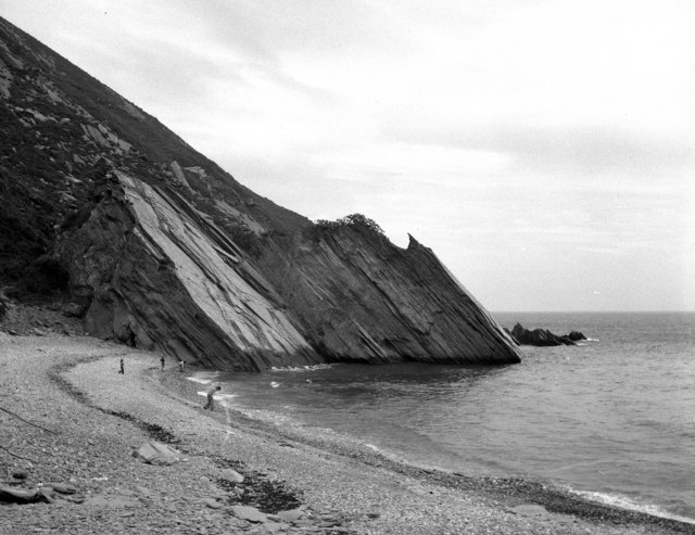
Fold mountains are of different ages. Young fold mountains, such as the Himalaya, Alps, Andes and Rockies, rose in the last few tens of millions of years and are high, sharp and still active. Old fold mountains, such as the Aravalli in India, the Appalachians in North America and the Urals, were folded hundreds of millions of years ago and have since been worn down into low, rounded hills.
Why it matters. Fold mountains such as the Himalaya, Alps, Andes and Rockies are the world's highest ranges. Anticlines are also important traps for oil and gas, which rise and collect beneath their arched caps, as in the oilfields of Assam and western India.
Faults: when rocks break
Near the surface, rocks are cold and brittle, so under stress they crack. If the rocks on either side of a crack move relative to each other, the crack is a fault. The surface along which they move is the fault plane, and a steep slope created by the movement is a fault scarp.
There are three basic kinds. Under tension, one block slides down the fault plane, forming a normal fault and stretching the crust. Under compression, one block is pushed up over the other, forming a reverse fault; when the angle is low and the movement mostly horizontal, it is a thrust fault. Where blocks slide sideways past each other, the fault is a strike-slip (transcurrent) fault, such as the San Andreas Fault.
Faults create striking landforms. When a long block drops between two parallel faults, it forms a rift valley or graben. The East African Rift Valley and the Rhine valley in Europe are famous examples, and the Narmada and Tapi flow through rift valleys in India.
When a block is raised between faults, or the land around it sinks, it forms a block mountain or horst, with a flat top and steep sides. The Vosges and Black Forest beside the Rhine graben are classic examples, and the Satpura range is often described as a block mountain.
The Himalaya show thrust faulting on a grand scale. As India pushes north, the crust is stacked in slices along a series of great thrusts that run the length of the range, with younger thrusts forming further south towards the plains. Sudden slips along these thrusts produce the large earthquakes of the Himalayan belt, and the Shillong Plateau in the North-East is a raised block bounded by faults.
Why it matters. Sudden movement along faults causes most earthquakes. Rift valleys hold great lakes and rivers and can become new oceans, as the Red Sea is doing. Engineers must map faults before building dams, tunnels and nuclear plants.
Volcanoes: fire from below
A volcano is an opening in the crust through which magma, gases, ash and rock fragments escape to the surface. Magma collects in a magma chamber, rises through a pipe and erupts from a vent, often at the bottom of a bowl-shaped crater. Once on the surface, molten rock is called lava; fragments thrown into the air, from fine ash to large volcanic bombs, are called pyroclastic material.
How violent an eruption is depends mainly on the lava. Basaltic lava, low in silica, is runny, so gas escapes easily and the eruption is quiet, with lava flowing far. Lava rich in silica is thick and sticky, trapping gas until it bursts out explosively, often with deadly pyroclastic flows of hot gas and ash racing down the slopes.
This explains the main types of volcano. Shield volcanoes, built of runny basalt, are broad with gentle slopes, like those of Hawaii. Composite volcanoes (stratovolcanoes), built of alternating layers of lava and ash, are steep, cone-shaped and explosive, like Fuji, Vesuvius and Pinatubo. A caldera forms when a volcano's top collapses into its emptied magma chamber, while flood basalts, such as the Deccan Traps, pour from long fissures and cover vast areas layer upon layer.
Volcanoes are called active if they are erupting or have erupted recently, dormant if they are quiet but could erupt, and extinct if no eruption is expected. Most active volcanoes lie along plate boundaries, especially the Pacific Ring of Fire, and much activity is hidden under the sea at mid-ocean ridges. Barren Island in the Andaman Sea is India's only active volcano.
Volcanoes are both destructive and creative. Krakatoa in 1883 and Pinatubo in 1991 threw so much dust and sulphur gas into the air that skies glowed and temperatures dipped worldwide. Yet weathered volcanic ash makes some of the world's most fertile soils, and volcanic regions supply geothermal energy.
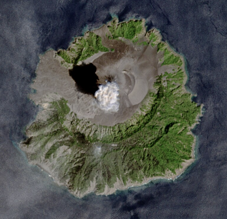
Why it matters. People live near volcanoes for their fertile soils and geothermal heat, so monitoring and evacuation plans save lives. Large eruptions also show how quickly the climate can respond to particles in the atmosphere.
Intrusive landforms and earthquakes
Not all magma reaches the surface. Much of it cools underground, forming bodies of igneous rock called intrusive forms. They are hidden at first, but when erosion strips away the rocks above, they appear as hills, ridges and domes.
The largest are batholiths, huge masses of granite formed deep in the crust at the roots of mountains. A laccolith is a dome-shaped body that pushes up the layers above it, and a lopolith is a saucer-shaped body sagging downward. A phacolith is a wavy body that fills the crests or troughs of folds.
Thinner forms are sills, horizontal sheets squeezed between layers, and dykes, vertical walls cutting across layers. Dykes often act as feeders that carried lava to the surface, and many are seen in the Deccan Traps. Because these igneous bodies are harder than the surrounding rocks, they often stand out as ridges after erosion.
The other sudden endogenic force is the earthquake, the shaking caused when rocks under stress suddenly slip along a fault. Earthquakes, like volcanoes, cluster along plate boundaries; the way they shake India and the waves they send across oceans are covered in earthquakes, seismic zones and tsunamis.
Why it matters. Granite batholiths and dykes provide building stone and often host metal ores. Intrusive bodies also help geologists trace past volcanic activity, and the sudden release of stress along faults explains why earthquakes strike where they do.
Mains lens: what, why, where and so what
This chapter supports GS Paper I (geomorphology) and links to disaster management and energy in GS Paper III. Here are four angles.
1. Forces and landforms. Compression gives folds and thrusts, tension gives rifts and block mountains, and vertical movement gives raised and drowned coasts. Answers can classify landforms by the force behind them.
2. Volcano types and hazards. Lava chemistry explains why Hawaii is calm and Pinatubo violent. Answers on volcanic hazards can link magma type, eruption style and risk.
3. Volcanoes and climate. Major eruptions inject sulphur aerosols that cool the planet for a year or two. This links geomorphology with climate questions.
4. Resources from endogenic activity. Anticlinal oil traps, ores in igneous intrusions, fertile volcanic soils and geothermal energy show that these forces also create wealth.
Mains lens: practice questions and answer plans
Now turn this understanding into written answers. The four questions below are written in the UPSC style, but they are our own practice questions, not previous-year questions. The real previous-year questions of your exam appear in the "Previous year questions" box once we have matched them with the official papers.
Q1. "Distinguish between epeirogenic and orogenic movements with examples." (150 words)
- Compare direction, scale and results.
- Give raised coasts and plateaus for epeirogeny, fold mountains for orogeny.
Q2. "How are rift valleys and block mountains formed? Give examples from India and the world." (150 words)
- Explain normal faulting and the graben–horst pair.
- Cite the East African Rift, Rhine, Narmada–Tapi and Satpura.
Q3. "Why are some volcanic eruptions quiet and others explosive? Discuss the landforms and hazards associated with each." (250 words)
- Introduction: Define a volcano and magma.
- Body: Explain silica, viscosity and gas; compare shield, composite, caldera and flood basalt with examples and hazards.
- Conclusion: Note monitoring and the benefits of volcanic regions.
Q4. "Describe the intrusive landforms formed by volcanic activity." (150 words)
- Cover batholith, laccolith, lopolith, phacolith, sill and dyke.
- End with their exposure by erosion and economic value.
Useful keywords: endogenic, exogenic, diastrophism, epeirogeny, orogeny, emergence, submergence, anticline, syncline, recumbent fold, nappe, normal fault, thrust, strike-slip, graben, horst, magma, lava, viscosity, shield, composite, caldera, flood basalt, Ring of Fire, batholith, laccolith, sill, dyke.
Quick revision
- Endogenic (inside, builds relief) vs exogenic (surface, wears down).
- Diastrophism: epeirogeny (vertical, broad; emergence and submergence) and orogeny (horizontal, mountain building). Sudden forces: volcanoes, earthquakes.
- Folds (compression): anticline (up), syncline (down), monocline; overturned, recumbent, nappes (Alps).
- Faults: normal (tension), reverse/thrust (compression), strike-slip (sideways). Graben = rift valley; horst = block mountain.
- Lava: low silica → runny, quiet; high silica → sticky, explosive.
- Volcano types: shield (Hawaii), composite (Fuji, Vesuvius), caldera, flood basalt (Deccan Traps). Active, dormant, extinct; Barren Island is India's only active volcano.
- Intrusive forms: batholith, laccolith, lopolith, phacolith, sill (horizontal), dyke (vertical).