

UPSC CAPF AC · Module 17 · standard depth · 12 min
Peninsular rivers, lakes and river linking
What UPSC CAPF AC asks from this chapter
Syllabus lines this chapter covers:
- Paper I: General Ability and Intelligence · Indian and World Geography: The questions shall cover the physical, social and economic aspects of geography pertaining to India and the World.
UPSC CAPF AC questions from this module are being sorted into our bank.
Cut to standard depth for UPSC CAPF AC. 11 deeper paragraphs are in the full chapter.
Start from zero: rivers of the old plateau
Imagine two rivers. One rises in snowfields, rushes down steep mountains and never runs dry. The other rises on an old, worn plateau, depends on monsoon rain, and in May may shrink to a few pools of water. The first is a Himalayan river; the second is a typical Peninsular river.
Peninsular rivers are much older. They have been flowing over the plateau for so long that they have worn their valleys broad and shallow, with gentle slopes. Their gradients are low, so they flow slowly in their lower courses.
Most of them are rain-fed. They swell during the monsoon and carry little water in summer, so they are seasonal, though big rivers still flow all year with reduced volume. Because they flow over hard rock, their courses are fairly fixed, and they do not wander in huge meanders like Himalayan rivers.
Where do these rivers begin? Most rise in a few high areas of the plateau. The Western Ghats feed the Godavari, Krishna and Kaveri, the Amarkantak plateau feeds the Narmada and the Son, the Chhota Nagpur plateau feeds the Damodar and Subarnarekha, and the Aravalli feed the Luni and Banas. Knowing these source areas makes it easy to remember the whole river map.
Why it matters. Seasonal flow means that farmers on the plateau depend on dams, tanks and groundwater to store monsoon water. Hard rocks make good dam sites but poor aquifers, so water stress is common. Sharing these limited waters between states is a major source of disputes.
How the plateau got its rivers
Why do almost all big Peninsular rivers flow east, even though many of them rise only a short distance from the Arabian Sea? The answer lies in three events in the plateau's long history.
First, in the early Tertiary period, the western side of the Peninsula sank below the sea. The original water divide, which was once in the middle, was left close to the west coast. That is why the Western Ghats act as the main divide today.
Second, when the Himalaya rose, the northern part of the Peninsular block cracked and sagged, forming long troughs bounded by faults. The Narmada and Tapi now flow west through these troughs. Because they flow in faulted troughs and not over alluvium, they form estuaries and not deltas.
Third, during the same period, the whole block tilted slightly towards the south-east. As a result, most rivers, such as the Mahanadi, Godavari, Krishna and Kaveri, flow east across the plateau into the Bay of Bengal. On the flat east coast, they drop their silt and build large deltas.
Why it matters. This history explains a basic pattern of Indian geography: big deltas and rice bowls on the east coast, and estuaries and natural harbours on the west coast. It also explains why the Western Ghats, though close to the sea, are the source of rivers that travel across the whole Peninsula.
The great east-flowing rivers
The Mahanadi rises near Sihawa in Chhattisgarh and flows through Odisha to the Bay of Bengal. The Hirakud dam on it was built to control floods and irrigate land, and its delta is densely populated. Smaller rivers further north, such as the Brahmani and Subarnarekha, drain the mineral-rich Chhota Nagpur plateau.
The Godavari is the largest Peninsular river. It rises near Trimbak in Nashik district of Maharashtra, flows about 1,465 km to the Bay of Bengal, and drains parts of several states. Because of its size, it is called the Dakshin Ganga; tributaries such as the Wainganga, Wardha, Penganga, Manjra and Indravati join it.
The Krishna rises in the Western Ghats near Mahabaleshwar and is the second largest east-flowing Peninsular river. Its main tributaries are the Koyna, Bhima and Tungabhadra, and it is shared by Maharashtra, Karnataka, Telangana and Andhra Pradesh. The Godavari and Krishna build a joint delta region on the Andhra coast.
The Kaveri rises in the Brahmagiri hills of Kodagu (Coorg) in Karnataka and flows about 800 km to the Bay of Bengal in Tamil Nadu. Its upper basin gets rain from the south-west monsoon and its lower basin from the north-east monsoon, so it flows more evenly through the year than other Peninsular rivers. It forms the Shivasamudram falls, used for one of India's earliest hydroelectric plants, and its fertile delta is called the granary of the south.
Between the Krishna and the Kaveri flows the smaller Penner, which cuts a gorge at Gandikota. Further south, the Vaigai and Tamraparni drain the dry southern tip of Tamil Nadu.
Why it matters. These rivers irrigate the rice bowls of the east coast and power many dams. Because they are shared by several states and carry limited water, they are at the centre of long disputes, such as those over the Kaveri and the Krishna. Their deltas are also highly exposed to cyclones and sea-level rise.
The west-flowing rivers
The Narmada rises at Amarkantak in Madhya Pradesh and flows west for about 1,312 km through a rift valley between the Vindhya in the north and the Satpura in the south. Near Jabalpur, it cuts a gorge through marble rocks and plunges over the Dhuandhar falls. It enters the Gulf of Khambhat through a broad estuary.
The Narmada has few large tributaries, because the hills on both sides lie close to its valley. The Sardar Sarovar dam on it supplies water to Gujarat and Rajasthan, but it also displaced many people, which led to the long Narmada Bachao Andolan.
The Tapi rises at Multai in the Satpura range in Betul district of Madhya Pradesh and flows west in a parallel trough, mostly through Maharashtra and Gujarat, to the sea near Surat. Further north, the Sabarmati and Mahi flow into the Gulf of Khambhat. The Luni rises in the Aravalli near Pushkar, flows through the dry Thar, and ends in the salty marshes of the Rann of Kachchh without reaching the open sea.
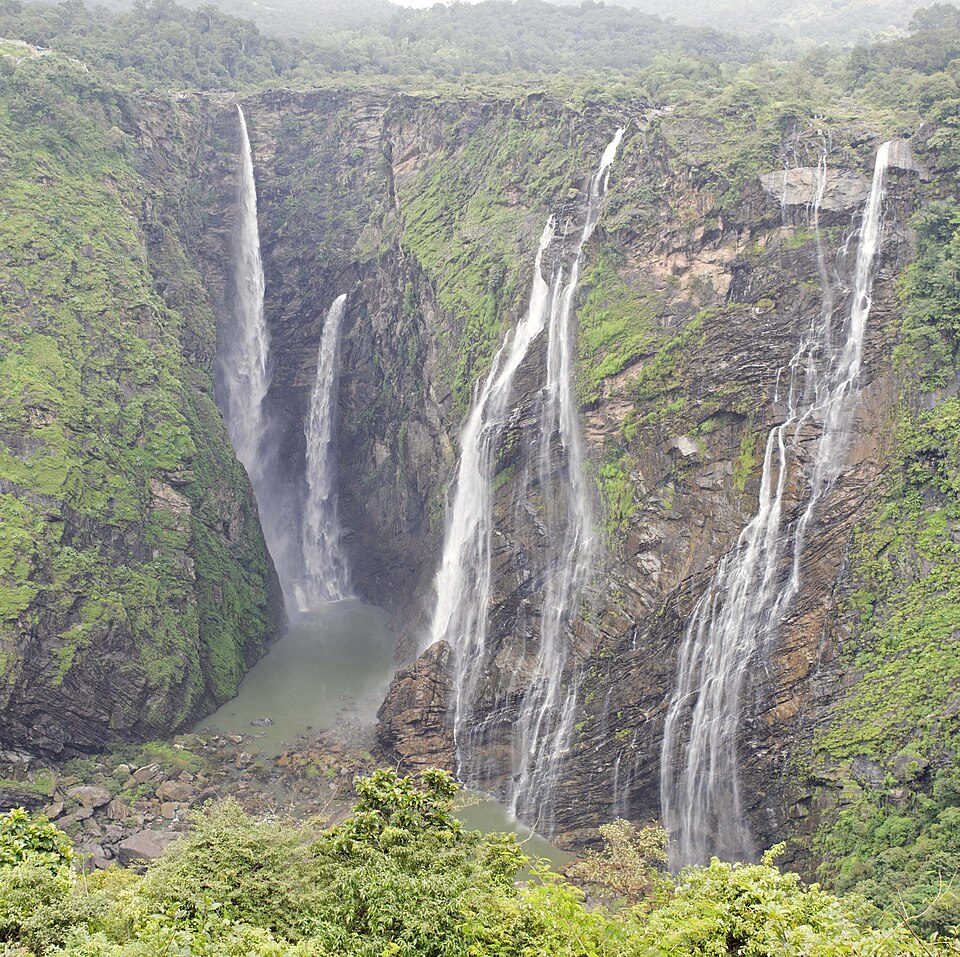
Many short, swift rivers rush down the steep western face of the Western Ghats to the Arabian Sea. They carry heavy rain water but over short distances, and they form waterfalls such as the Jog Falls on the Sharavati in Karnataka. Kerala's rivers, such as the Periyar, feed the backwaters and many small hydroelectric projects.
Why it matters. West-flowing rivers have steep falls ideal for hydropower, and their estuaries offer sites for ports. The Narmada debate is a classic case study of the trade-off between large dams, irrigation and the rights of displaced people. The short Western Ghats rivers also face pressure from mining, sand extraction and forest loss.
Lakes of India
A lake is a body of water held in a hollow of the land. India has lakes of many kinds, and how a lake forms decides its shape, depth and water quality.
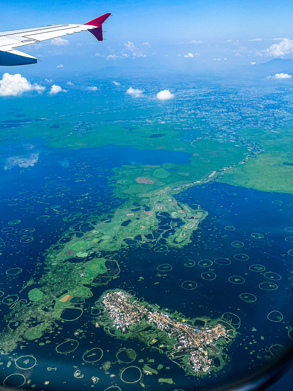
In the mountains, lakes form in tectonic hollows or behind glacial deposits. Wular Lake in Jammu and Kashmir, the largest freshwater lake in India, and the famous Dal Lake lie in the Kashmir valley, while Nainital and Bhimtal lie in the Kumaon hills. In Manipur, Loktak Lake is known for its floating islands of vegetation called phumdis, one of which forms a national park.
On flood plains, a meandering river may cut off one of its loops, leaving a crescent-shaped oxbow lake. Along the coast, sand bars cut off parts of the sea to form lagoons, such as Chilika, Pulicat, Kolleru and Vembanad. In dry Rajasthan, inland drainage forms salt lakes, such as Sambhar, which is used to make salt.
Many lakes are man-made, such as the reservoirs behind dams, while old cities in the south and in central India are dotted with tanks built centuries ago to store monsoon water.
Why it matters. Lakes control floods by storing water, recharge groundwater, support fisheries and tourism, and moderate local climate. Many are shrinking because of encroachment, silt and sewage, and urban lakes in cities such as Bengaluru show how fast they can die. Protecting wetlands is therefore part of both water security and disaster management.
Sharing and linking rivers
India's water is unevenly spread. The Brahmaputra and Ganga basins often have more water than they can use, while much of the Peninsula, western India and Rajasthan face scarcity. This mismatch led to the idea of linking rivers, moving surplus water to deficit areas through canals and reservoirs.
In 1980, the government prepared a National Perspective Plan with two parts: a Himalayan component and a Peninsular component. The National Water Development Agency has studied 30 links under this plan. The Ken–Betwa link in Bundelkhand, shared by Madhya Pradesh and Uttar Pradesh, is the first link to be taken up for construction.
Supporters say linking can expand irrigation, reduce droughts and floods, and generate power. Critics point to huge costs, displacement, loss of forests and wildlife (the Ken–Betwa link affects part of the Panna tiger reserve), changes to river ecology and deltas, and disputes between states over who gives water.
Because rivers cross state borders, sharing them needs legal rules. Article 262 of the Constitution lets Parliament provide for settling inter-state river water disputes, and the Inter-State River Water Disputes Act, 1956 sets up tribunals. Disputes over the Kaveri, Krishna, Godavari, Narmada and Mahadayi have all gone to such tribunals.
Why it matters. Water is a state subject, but rivers ignore state borders, so river sharing tests Indian federalism. Linking rivers could change the map of water across the country, for better or worse. Good answers weigh engineering benefits against ecological and social costs and suggest local options such as watershed management and water efficiency.
Quick revision
- Peninsular rivers: older, rain-fed, seasonal, broad shallow valleys, fixed courses.
- Three events: western flank sank (early Tertiary), northern troughs (Narmada, Tapi), south-east tilt.
- East-flowing → deltas; Narmada and Tapi → estuaries.
- Godavari: largest, Trimbak (Nashik), about 1,465 km, Dakshin Ganga.
- Krishna: Mahabaleshwar; Koyna, Bhima, Tungabhadra. Kaveri: Brahmagiri (Kodagu), rain from both monsoons, Shivasamudram. Mahanadi: Sihawa, Hirakud.
- Narmada: Amarkantak, rift between Vindhya and Satpura, Dhuandhar, Sardar Sarovar. Tapi: Multai (Betul). Luni ends in the Rann of Kachchh. Jog Falls on the Sharavati.
- Lakes: Wular (largest freshwater), Loktak (phumdis), Sambhar (salt), lagoons Chilika, Pulicat, Kolleru, Vembanad; oxbow lakes on flood plains.
- River linking: National Perspective Plan 1980, 30 links, Ken–Betwa first; disputes under Article 262 and the 1956 Act.