

UPSC CDS · Module 21 · standard depth · 12 min
Africa and West Asia: plateaus, rifts, rivers and oil
What UPSC CDS asks from this chapter
Syllabus lines this chapter covers:
- General Knowledge (all academies) · The paper will also include questions on History of India and Geography of a nature which candidate should be able to answer without special study.
UPSC CDS questions from this module are being sorted into our bank.
Cut to standard depth for UPSC CDS. 11 deeper paragraphs are in the full chapter.
Start from zero: the plateau continent
Africa is the second-largest continent after Asia. It is joined to Asia only by the narrow Isthmus of Suez, now cut by the Suez Canal, and is separated from Europe by the Strait of Gibraltar, only about 14 km wide.
The equator passes almost through the middle of Africa, and the continent lies mostly within the tropics. So its climate and vegetation belts are almost mirror images north and south of the equator: equatorial rainforest in the centre, savanna on either side, hot deserts further out (the Sahara in the north, the Kalahari and Namib in the south), and Mediterranean climates at the far north-western and south-western tips.
Much of Africa is a vast plateau, a block of ancient rock that rises steeply from narrow coastal plains. The plateau is higher in the south and east than in the north and west. This is why many African rivers plunge over waterfalls and rapids near the coast, which limits navigation from the sea but offers huge hydroelectric potential.
Why it matters. Africa's plateau shape, rivers and mineral wealth explain its history of colonial trade and its present importance for energy and critical minerals. India has growing trade and development ties with African countries.
Rift valleys, volcanoes and mountains
The most striking feature of eastern Africa is the Great Rift Valley. It runs for thousands of kilometres from the Red Sea and the Jordan valley in West Asia, through Ethiopia, Kenya and Tanzania, to Mozambique. It formed where the Earth's crust is being pulled apart, so long blocks of land have sunk between parallel faults.
The rift holds a chain of long, deep lakes, including Lake Tanganyika, the deepest in Africa and one of the deepest in the world, and Lake Malawi. Lake Victoria, the largest lake in Africa, lies in a shallow basin between the two arms of the rift and is shared by Uganda, Kenya and Tanzania.
Volcanoes rise along and near the rift. Mount Kilimanjaro in Tanzania, a dormant volcano with a snow-capped summit near the equator, is Africa's highest peak, and Mount Kenya is another. The Ethiopian Highlands are a high volcanic plateau where the Blue Nile rises.
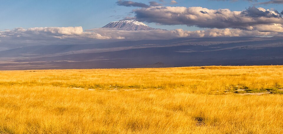
Africa's other mountains lie at its edges. The Atlas Mountains in Morocco, Algeria and Tunisia are young fold mountains, related to the Alps of Europe. The Drakensberg in South Africa and Lesotho form the high, steep eastern edge of the southern African plateau.
Why it matters. The rift shows plate tectonics at work, as eastern Africa may one day split away. Its lakes and highlands support dense farming populations and wildlife tourism.
The great rivers of Africa
The Nile is one of the longest rivers in the world. It is formed by two main streams: the White Nile, which flows out of Lake Victoria, and the Blue Nile, which rises in Lake Tana in the Ethiopian Highlands and brings most of the water and silt during the summer rains. They meet at Khartoum in Sudan, and the river then crosses the Sahara to form a large delta on the Mediterranean.
Egypt's civilisation grew along this narrow green strip in the desert. The Aswan High Dam in Egypt now controls floods and provides irrigation and power, while Ethiopia's large new dam on the Blue Nile has raised questions about sharing the river's water among upstream and downstream countries.
The Congo drains the equatorial rainforest and has the second-largest discharge of any river in the world, after the Amazon. It is the only major river that crosses the equator twice, so some of its tributaries are always in a rainy season, keeping its flow steady. The Niger has an unusual course: it rises only about 250 km from the Atlantic in the Guinea highlands, flows north-east towards the Sahara, where it forms a wide inland delta, and then turns south-east to enter the Gulf of Guinea through a large oil-rich delta in Nigeria.
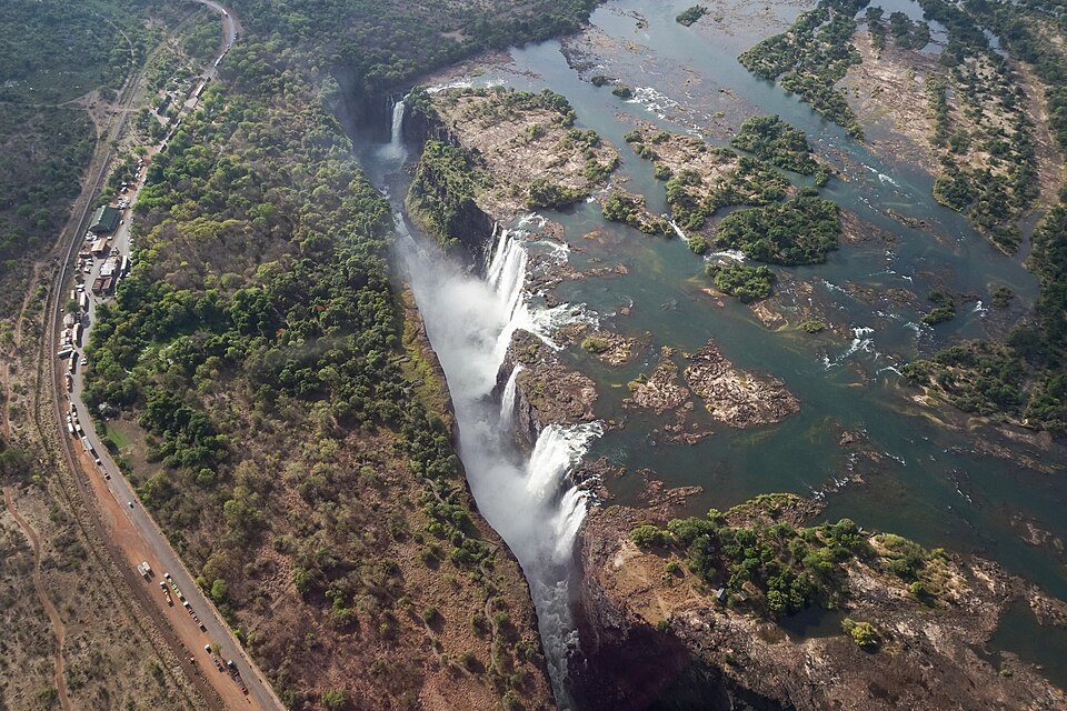
In the south, the Zambezi plunges over the Victoria Falls on the Zambia–Zimbabwe border and is dammed at Kariba and Cahora Bassa. The Orange flows west to the Atlantic, and the Limpopo flows east to the Indian Ocean, crossing the Tropic of Capricorn twice.
Why it matters. Africa's rivers hold vast hydropower potential and are lifelines for farming. Shared rivers, especially the Nile, are central to regional diplomacy.
Resources and regions of Africa
Africa's ancient rocks are rich in minerals. South Africa has long been a world leader in gold and platinum, mined in the Witwatersrand region around Johannesburg. Diamonds come from Botswana, South Africa, the Democratic Republic of the Congo, Angola and Namibia.
The Copperbelt of Zambia and the Democratic Republic of the Congo is one of the world's richest copper regions, and the Democratic Republic of the Congo produces most of the world's cobalt, vital for batteries. Oil and gas come from Nigeria and the Gulf of Guinea, Libya, Algeria, Angola and Egypt, and uranium from Niger and Namibia.
Africa is often divided into regions. North Africa, along the Mediterranean, is largely Arab and desert. West Africa, along the Gulf of Guinea, grows cocoa, especially in Côte d'Ivoire and Ghana, and has oil in Nigeria. East Africa includes the Horn of Africa, the rift highlands and the coast facing India.
Central Africa is dominated by the Congo basin rainforest, and Southern Africa by plateaus, mineral wealth and the industrial economy of South Africa. The Sahel, the semi-arid belt along the southern edge of the Sahara, faces recurring drought and conflict.
Why it matters. Africa holds many critical minerals for clean energy, from cobalt to platinum. India sources oil, gold, diamonds and minerals from Africa and is a major development partner there.
West Asia: seas, straits and oil
West Asia stretches from Turkey and the eastern Mediterranean to Iran and the Arabian Peninsula. Much of it is dry: the Arabian Peninsula is a tilted plateau of deserts, while Turkey and Iran are high plateaus ringed by mountains such as the Taurus, Pontic, Zagros and Elburz. The fertile Mesopotamian plain of the Tigris and Euphrates in Iraq was home to some of the earliest cities.
The region's greatest resource is oil and natural gas. The countries around the Persian Gulf, such as Saudi Arabia, Iraq, Iran, Kuwait, the United Arab Emirates and Qatar, hold the largest proven oil reserves in the world, formed in thick sedimentary rocks. Oil wealth has built modern cities in the desert and attracted millions of migrant workers, including many from India.
West Asia controls several vital sea routes. The Suez Canal, opened in 1869 in Egypt, links the Mediterranean Sea with the Red Sea, so ships between Europe and Asia avoid the long voyage around the Cape of Good Hope. At the southern end of the Red Sea, the narrow Bab-el-Mandeb strait leads to the Gulf of Aden, and at the mouth of the Persian Gulf the Strait of Hormuz leads to the Gulf of Oman, carrying a large share of the world's seaborne oil.
In the north-west, the Bosporus and Dardanelles straits, joined by the Sea of Marmara, link the Black Sea with the Mediterranean and divide Istanbul between Europe and Asia. Inland, the Dead Sea, shared by Jordan and Israel, lies at the lowest point on land and is so salty that people float easily.
Why it matters. India imports much of its oil and gas from the Gulf, and millions of Indians work there. Any disruption at Hormuz, Bab-el-Mandeb or Suez directly affects India's energy security and trade.
Climate and people of Africa
Because Africa straddles the equator, its climate belts form a neat sequence. Around the equator, in the Congo basin and the Gulf of Guinea coast, lies the hot, wet equatorial climate with rainforest. North and south of it lie broad belts of savanna, with wet summers and dry winters, home to Africa's famous wildlife.
Beyond the savannas lie the hot deserts: the Sahara, the largest hot desert in the world, in the north, and the Kalahari and the coastal Namib in the south-west. At the far north-western coast, around the Atlas, and at the south-western tip around Cape Town, the climate is Mediterranean, with dry summers and wet winters, ideal for grapes and citrus.
East Africa breaks this neat pattern. Its high plateaus and mountains are much cooler than their latitude suggests, so cities such as Nairobi and Addis Ababa enjoy mild climates, and the highlands support tea, coffee and dense farming populations.
Africa has the fastest-growing population of any continent, and many of its cities are expanding rapidly. Its people speak more than a thousand languages, and its colonial borders, often drawn without regard to ethnic groups or rivers, still shape politics today.
Why it matters. Africa's young, growing population makes it central to the world's future workforce and markets. Climate change threatens its farming, especially in the Sahel and the Horn of Africa.
Quick revision
- Africa: second-largest continent; equator through the middle; mirrored climate belts; plateau continent.
- Great Rift Valley: Red Sea/Jordan to Mozambique; lakes Tanganyika (deepest in Africa), Malawi; Victoria (largest in Africa).
- Kilimanjaro: highest in Africa, dormant volcano (Tanzania). Atlas = fold; Drakensberg = plateau edge.
- Nile: White (Lake Victoria) + Blue (Lake Tana) meet at Khartoum; Aswan High Dam.
- Congo: crosses equator twice, second-largest discharge. Niger: inland delta, Gulf of Guinea. Zambezi: Victoria Falls. Limpopo: crosses Tropic of Capricorn twice.
- Minerals: gold and platinum (South Africa), diamonds (Botswana), copper and cobalt (Copperbelt), oil (Nigeria, Libya, Algeria, Angola).
- Suez Canal 1869: Mediterranean–Red Sea. Bab-el-Mandeb: Red Sea–Gulf of Aden. Hormuz: Persian Gulf–Gulf of Oman.
- Bosporus and Dardanelles: Black Sea–Mediterranean.