General Knowledge (all academies) · The paper will also include questions on History of India and Geography of a nature which candidate should be able to answer without special study.
UPSC CDS questions from this module are being sorted into our bank.
Cut to standard depth for UPSC CDS. 13 deeper paragraphs are in the full chapter.
Start from zero: where does tomorrow's weather come from?
On a winter morning in north India, the news may say that a cold wave is coming or that rain is expected from the west. In summer, coastal states may be told to prepare for a cyclone. In each case, the weather is not made on the spot; it arrives from somewhere else.
Weather systems are made of big blocks of air
Weather travels because air travels. Huge blocks of air form over oceans, deserts or icy lands and take on their heat or cold, dryness or moisture. When such a block moves, it carries that weather with it.
Where two very different blocks of air meet, the boundary becomes restless. Warm air is pushed up, clouds form and storms can grow. Some storms spin into great whirls that can stretch across hundreds of kilometres.
Keep three questions in mind as you read: What are these blocks of air, and where do they meet? How do storms form in the middle latitudes and in the tropics? And what fast winds high above steer the weather that reaches India?
Why it matters. This chapter explains most of the dramatic weather that makes news: cyclones on the east coast, cold waves and winter rain in the north, and violent thunderstorms before the monsoon. Understanding how these systems form is the base of forecasting, disaster warning and planning for farming and transport.
Air masses: big blocks of air with a personality
When air stays for a long time over a large, uniform area, such as an ocean, a desert or a snowfield, it slowly takes on the character of that surface. Air over a warm sea becomes warm and moist, while air over a frozen land becomes cold and dry. Such a large body of air, with nearly the same temperature and humidity throughout, is called an air mass.
Source regions of the main air masses
The area where an air mass forms is called its source region. A good source region is large and fairly flat, and the air must stay over it long enough to absorb its character. Warm tropical oceans, hot deserts, cold northern continents and the Arctic are the main source regions of the world.
Air masses are named after their source regions. Maritime tropical air forms over warm oceans and is warm and moist. Continental tropical air forms over hot deserts and is hot and dry, while maritime polar air forms over cold oceans and is cool and moist.
Continental polar air forms over cold northern lands and is cold and dry. Continental arctic air, formed over the Arctic, is the coldest of all. A quick way to remember them is that "maritime" means moist, "continental" means dry, "tropical" means warm and "polar" means cold.
Five air masses and their character
Once an air mass leaves its source region, it carries its weather with it and slowly changes as it moves. A cold, dry air mass sweeping over a warm sea picks up heat and moisture from below. A warm, moist air mass moving over cold land cools from below and may produce fog.
Why it matters. Air masses explain why weather can change suddenly when the wind shifts. A cold wave in north India in winter means cold, dry air arriving from the north, while sultry, humid days mean moist air from the sea. Forecasters track air masses to predict when such changes will come.
Fronts: where two air masses meet
Pour cold water and warm water gently into the same glass and they do not mix at once; the cold water slides to the bottom. Air masses behave in the same way. When a cold air mass meets a warm one, they do not blend easily, and a boundary zone forms between them.
Cold front and warm front
This boundary is called a front, and the process by which it forms is called frontogenesis. Because cold air is heavier, it pushes under the warm air, and the warm air is forced to rise. Rising air cools, its moisture condenses, and clouds and rain form along the front.
There are four types of fronts. At a cold front, cold air advances and pushes sharply under the warm air, which is lifted steeply. This builds tall clouds and brings short, heavy showers and sometimes thunderstorms, followed by cooler, clearer weather.
At a warm front, warm air advances and slides gently up over the cold air. The rise is slow, so wide sheets of layered cloud form and steady, lighter rain can last for many hours. A stationary front forms when neither air mass moves forward, and the cloudy, wet weather can stay over one area for days.
Four kinds of front on a weather map
The fourth type is the occluded front. It forms when a fast-moving cold front catches up with a warm front and lifts all the warm air off the ground. Fronts are typical of the middle latitudes, where cold polar air and warm tropical air meet. In the tropics the air masses are too similar, so true fronts are absent.
Why it matters. Fronts explain why the weather in places like Europe or North America changes every few days, as air masses take turns crossing them. They also explain the different kinds of rain: short, heavy showers at a cold front and long, gentle rain at a warm front. For India, the same mid-latitude systems reach the north-west in winter and shape its winter weather.
Temperate cyclones: storms of the middle latitudes
A cyclone is a system of low pressure with winds spiralling inward, turning anticlockwise in the northern hemisphere and clockwise in the southern hemisphere. There are two main families of cyclones, and they are born in very different ways. The first family forms in the middle latitudes and is called the extra-tropical or temperate cyclone.
Life of a temperate cyclone
Temperate cyclones form along the polar front, the long boundary where cold polar air meets warm air from lower latitudes. A small wave appears on this front, and the warm air begins to push north while the cold air swings in behind it. The wave deepens into a whirl of low pressure.
A fully formed temperate cyclone has a warm front on its leading side and a cold front behind it. Between the two lies a wedge of warm air called the warm sector. Because cold fronts move faster, the cold front gradually catches up with the warm front, lifts the warm air off the ground and forms an occluded front, after which the cyclone slowly dies out.
Temperate and tropical cyclones compared
These storms are large, often spreading across more than a thousand kilometres. They form over both land and sea and, carried by the westerly winds, they move from west to east. They bring a sequence of weather: rain ahead of the warm front, mild weather in the warm sector, and then showers and colder air after the cold front passes.
Why it matters. Temperate cyclones are the everyday weather-makers of Europe, North America and other mid-latitude lands, which is why their weather is so changeable. They supply much of the rain and snow that farms and rivers there depend on. Some weaker cousins of these systems drift into north-western India in winter, and their effect on Indian weather is explained with the jet streams below.
Tropical cyclones: the most violent storms on Earth
The second family of cyclones forms over warm tropical seas. These tropical cyclones are smaller than temperate cyclones, but far more violent. They form only when several conditions come together.
Inside a tropical cyclone
First, there must be a large sea surface warmer than about 27°C, to supply heat and moisture. Second, there must be enough Coriolis force to set the air spinning, which is why they do not form right on the equator. Third, the wind speed should not change much with height, so that the growing storm is not torn apart, and there should already be a weak low-pressure area to start the whirl, with air spreading out aloft to keep the pump working.
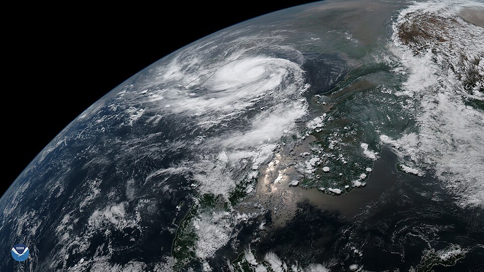
Cyclone Fani over the Bay of Bengal, seen from a satellite (2019)Photo: NOAA, Public domain, via Wikimedia Commons
The engine of a tropical cyclone is water vapour. Warm, moist air rises over the sea, cools, and its water vapour condenses into cloud. Each time this happens, heat is released into the air, the air rises faster, more moist air is sucked in below, and the storm strengthens.
One storm, four names
A mature tropical cyclone has a striking structure. At its centre lies the eye, a calm area of sinking air, often with clear skies. Around it stands the eye wall, a ring of towering clouds where the winds are strongest and the rain heaviest, and beyond that spiral bands of rain extend outward.
The engine of a tropical cyclone
These storms have different names in different oceans. They are called cyclones in the Indian Ocean, hurricanes in the Atlantic, typhoons in the western Pacific and the South China Sea, and willy-willies in western Australia. The name changes, but the physics is the same.
When a tropical cyclone moves onto land, it loses its supply of warm, moist air, so it weakens after landfall. But the coast suffers the most. Strong winds push sea water towards the shore and raise its level, and this storm surge floods low coastal land, causing much of the damage and loss of life.
Why it matters. India's east coast faces the Bay of Bengal, where most of the cyclones that affect India form, and the west coast is also exposed to cyclones from the Arabian Sea. Wind, heavy rain and storm surge destroy homes, crops, roads and power lines. This is why cyclone warnings, evacuation and coastal shelters are central to disaster management.
Jet streams, western disturbances and thunderstorms
High in the upper troposphere, about as high as passenger jets fly, there are narrow belts of extremely fast wind. These are called jet streams. They are like rivers of air, a few hundred kilometres wide, flowing mostly from west to east.
Jet streams over India in winter and summer
For India, the most important is the subtropical westerly jet stream. In winter it blows south of the Himalaya, over north India. In summer it shifts north, beyond the Tibetan plateau, and this seasonal shift is closely linked to the arrival of the monsoon.
In winter, this westerly jet acts like a conveyor belt for weather. It carries low-pressure systems from the Mediterranean region eastward across West Asia into north-western India. These systems are called western disturbances.
Journey of a western disturbance
Western disturbances bring winter rain to the plains of north-western India and snow to the western Himalaya. This winter rain is small in amount but very valuable. It helps the rabi crops, especially wheat, and the snow feeds the rivers that flow in summer.
In summer, a different jet appears over India. An easterly jet stream blows over the peninsula, and it is linked to the monsoon circulation. So jet streams help explain both India's winter rain and its summer monsoon.
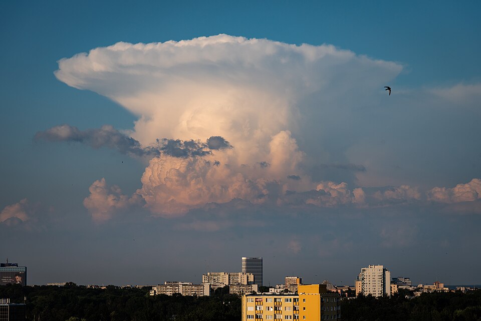
A thunderstorm cloud (cumulonimbus) on a hot afternoonPhoto: Kamil Nowacki, CC BY-SA 4.0, via Wikimedia Commons
Closer to the ground, the hottest months bring another kind of storm. On hot, humid afternoons, strong convection builds tall clouds into thunderstorms, with lightning, gusty winds, heavy showers and sometimes hail. These storms are short but intense.
Rarely, a thunderstorm produces a tornado, a very small but extremely violent whirl of air that touches the ground. Over the sea, a similar whirl is called a waterspout. Tornadoes are most common in the middle latitudes, especially in the plains of North America.
Why it matters. Jet streams link India's weather to events thousands of kilometres away. A good or poor season of western disturbances changes wheat yields and the snow that later feeds rivers, while the shift of the jets in summer is part of the monsoon story. Thunderstorms and lightning before the monsoon also cause many deaths every year, which makes lightning warnings an important public safety tool.
Quick revision
An air mass is a large body of air with nearly uniform temperature and humidity, taken from its source region.
The main types are maritime tropical, continental tropical, maritime polar, continental polar and continental arctic: maritime means moist, continental dry, tropical warm and polar cold.
A front is the boundary between two air masses, and the four types are cold, warm, stationary and occluded; fronts belong to the middle latitudes, not the tropics.
Temperate cyclones form on the polar front, are large, form over land and sea and move west to east.
Tropical cyclones need warm seas above about 27°C, the Coriolis force, little change of wind with height and a pre-existing low, and they draw energy from condensation.
A tropical cyclone has a calm eye and a violent eye wall, it weakens after landfall, and its storm surge causes much of the coastal damage.
They are called cyclones (Indian Ocean), hurricanes (Atlantic), typhoons (western Pacific) and willy-willies (western Australia).
The subtropical westerly jet lies south of the Himalaya in winter and brings western disturbances with rain and snow that help rabi crops, while an easterly jet blows over the peninsula in summer.
Exam-style questions on this chapter. Pick an answer to see the explanation. 0 of 8 answered
An air mass formed over a hot desert is classed as:
Consider the following statements about fronts:
1. An occluded front forms when a cold front overtakes a warm front.
2. Fronts are common in the tropics.
Which of the statements given above is/are correct?
Temperate (extra-tropical) cyclones generally move:
Which of the following are favourable conditions for a tropical cyclone?
1. A sea surface temperature above about 27°C
2. Strong change in wind speed with height
Select the correct answer:
In a mature tropical cyclone, the strongest winds and heaviest rain are found in the:
Tropical cyclones in the western Pacific Ocean are called:
Western disturbances that bring winter rain to north-western India originate in the:
A tropical cyclone weakens after landfall mainly because:
Previous year questions
Previous year questions for UPSC CSE will appear here once each one is checked word for word against the official question paper.
Frequently asked questions
What conditions are needed for a tropical cyclone?
A large warm sea surface above about 27 °C, enough Coriolis force (so not right at the equator), low vertical wind shear, and a pre-existing low-pressure disturbance.
What is the eye of a cyclone?
The eye is the calm, nearly cloud-free centre of a tropical cyclone, where air sinks. It is ringed by the eyewall, which has the strongest winds and heaviest rain.
What are western disturbances?
Western disturbances are low-pressure systems from the Mediterranean region carried east by the subtropical westerly jet. They bring winter rain to north-west India and snow to the western Himalaya.
What are tropical cyclones called in different regions?
They are cyclones in the Indian Ocean, hurricanes in the Atlantic and eastern Pacific, typhoons in the western Pacific, and willy-willies in north-west Australia.