

UPSC CDS · Module 17 · standard depth · 14 min
Drainage and the Himalayan rivers
What UPSC CDS asks from this chapter
Syllabus lines this chapter covers:
- General Knowledge (all academies) · General Knowledge including knowledge of current events and of such matters of everyday observation and experience in their scientific aspects as may be expected of an educated person who has not made a special study of any scientific subject.
- General Knowledge (all academies) · The paper will also include questions on History of India and Geography of a nature which candidate should be able to answer without special study.
UPSC CDS questions from this module are being sorted into our bank.
Cut to standard depth for UPSC CDS. 11 deeper paragraphs are in the full chapter.
Start from zero: how rivers organise land
Pour a bucket of water on a sloping courtyard. It does not spread evenly; it gathers into small lines, the lines join, and finally one stream leaves through the lowest corner. Rivers do exactly this on the scale of a whole country.
The area from which all the rain and snowmelt flows into one river and its tributaries is called its river basin or catchment. The higher land that separates one basin from the next is called a water divide or watershed. A single drop of rain falling on a divide may end up in two different seas, depending on which side it rolls down.
When we look at rivers from above, they make shapes called drainage patterns. On uniform rock, rivers branch like a tree, a dendritic pattern, as on the Northern Plains. Where hard and soft rocks alternate in bands, tributaries join at right angles, a trellis pattern.
When rivers flow out in all directions from a high central point, the pattern is radial, as around the Amarkantak plateau. When they flow inwards into a lake or low basin, the pattern is centripetal. Where rocks are cut by joints at right angles, the pattern is rectangular.
Why it matters. The river basin is the natural unit for planning water, floods and irrigation, because what happens upstream affects everyone downstream. Disputes between states and countries are often disputes over shared basins. Drainage patterns also reveal the rocks and slopes underneath, which helps in planning dams and roads.
Two river families and how they were born
India's rivers belong to two families. The Himalayan rivers, the Indus, Ganga and Brahmaputra systems, come from the young northern mountains. The Peninsular rivers, such as the Godavari, Krishna, Kaveri, Mahanadi, Narmada and Tapi, flow over the old plateau.
Most of India's water flows east. About 77% of the country's drainage area drains into the Bay of Bengal, and only about 23% into the Arabian Sea. By size, a basin larger than 20,000 sq km is called major, one between 2,000 and 20,000 sq km medium, and a smaller one minor.
Himalayan rivers are perennial. They get water from melting snow and glaciers in summer and from monsoon rain, so they rarely run dry. In the mountains they flow fast and cut deep V-shaped valleys and gorges; in the plains they slow down, wander in loops called meanders, spread out in floods and build deltas at the sea.
Some Himalayan rivers are older than the mountains they cross. The Indus, Satluj and Brahmaputra were already flowing when the Himalaya began to rise, and they kept cutting down as the land rose, creating deep gorges. Such rivers are called antecedent rivers.
Geologists also suggest that, long ago, one great river called the Indo-Brahma or Shiwalik river flowed along the foot of the Himalaya from Assam to Punjab and into the Gulf of Sind. Later, the Potwar plateau rose and created a divide in the west, while the Malda gap area between the Rajmahal hills and the Meghalaya plateau sank in the east. The old river broke into three systems: the Indus, the Ganga and the Brahmaputra.
Why it matters. Perennial Himalayan rivers make year-round canal irrigation possible, which is why the northern plains are India's food bowl. Their young, fast upper courses also hold great hydropower potential. But the same rivers carry huge silt loads and flood often, so they must be managed with care.
The Indus system
The Indus, or Sindhu, rises in Tibet near the Kailash range and Lake Mansarovar. It enters India in Ladakh, flowing north-west between the Ladakh and Zanskar ranges, and is joined by Himalayan tributaries such as the Shyok, Zanskar and Dras. It then turns south into Pakistan, crosses the plains and enters the Arabian Sea near Karachi.
In the plains, the Indus receives the five rivers that gave Punjab its name, "land of five waters": the Jhelum, Chenab, Ravi, Beas and Satluj. The Jhelum rises at Verinag in the Kashmir valley and flows through Wular Lake before entering Pakistan through a deep gorge. The Chenab is formed at Tandi in Himachal Pradesh, where the Chandra and Bhaga meet.
The Ravi drains the area between the Pir Panjal and Dhauladhar ranges. The Beas rises at Beas Kund near the Rohtang Pass and joins the Satluj at Harike in Punjab, lying entirely within India. The Satluj rises near Rakas Tal and Mansarovar in Tibet, enters India through the Shipki La, and feeds the Bhakra Nangal dam, one of India's earliest large multipurpose projects.
These rivers are shared with Pakistan, so their water is governed by the Indus Waters Treaty of 1960, brokered by the World Bank. Under it, the three eastern rivers (Ravi, Beas and Satluj) were given to India, and the three western rivers (Indus, Jhelum and Chenab) mainly to Pakistan, with India allowed limited uses such as run-of-the-river hydropower. In April 2025, after a terror attack, India announced that it was holding the treaty in abeyance.
Why it matters. The Indus system irrigates the granaries of Punjab and Haryana through a dense network of canals. The treaty is a central issue in India–Pakistan relations, and how India uses the western rivers is now a live policy question. Hydropower projects on the Chenab and Jhelum in Jammu and Kashmir are closely linked to this debate.
The Ganga system
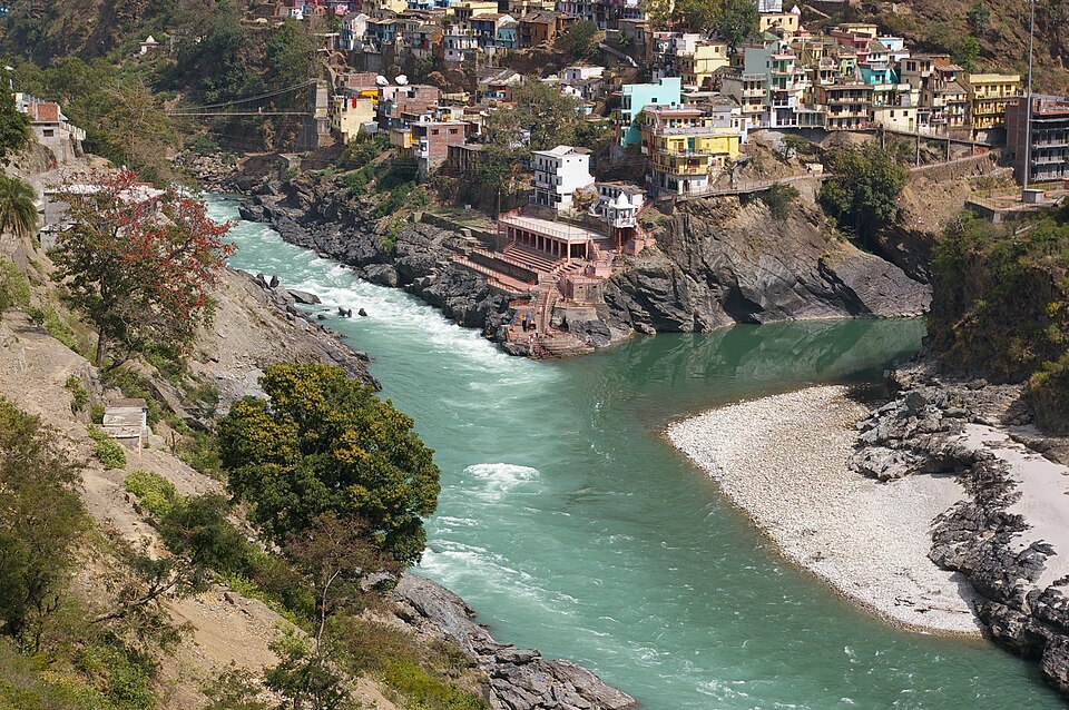
The Ganga begins as the Bhagirathi, which flows out of the Gangotri glacier at Gaumukh in Uttarakhand. At Devprayag, the Bhagirathi meets the Alaknanda, and from here the river is called the Ganga. It leaves the mountains at Haridwar, flows across the plains for about 2,525 km in all, and has the largest river basin in India.
From the Himalaya come its left-bank tributaries: the Ramganga, Gomti, Ghaghara, Gandak, Kosi and Mahananda. Fed by snow and rain, they bring large volumes of water and silt. The Kosi, which drains Nepal and the Everest region, shifts its course often and floods widely, so it is called the "sorrow of Bihar".
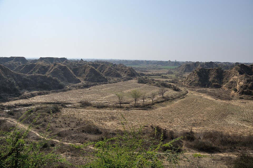
From the south come its right-bank tributaries. The most important is the Yamuna, which rises at the Yamunotri glacier and joins the Ganga at Prayagraj; it in turn receives the Chambal, Betwa and Ken from the Peninsula. The Chambal has cut deep badland ravines in Madhya Pradesh and Rajasthan, while the Son rises at Amarkantak and the Damodar, once called the "sorrow of Bengal", drains the Chhota Nagpur plateau.
Near Farakka, the Ganga divides. One branch, the Bhagirathi–Hooghly, flows south through West Bengal past Kolkata, and the main stream enters Bangladesh as the Padma, where it joins the Brahmaputra. Together they form the Sundarban delta, the largest delta in the world, covered with mangroves and home to the Bengal tiger.
The Ganga supports a huge population, but it is badly polluted by sewage, industrial waste and low summer flows. The Namami Gange programme, launched in 2014, builds sewage treatment plants, cleans river fronts and protects river life such as the Gangetic dolphin.
Why it matters. The Ganga basin feeds and employs hundreds of millions of people across several states. Its floods, especially in north Bihar, cause great losses every year, while pollution and over-extraction threaten its health. Managing it needs cooperation between upstream and downstream states, and with Nepal and Bangladesh.
The Brahmaputra system
The Brahmaputra rises in the Chemayungdung glacier near the Kailash range, close to the sources of the Indus and Satluj. In Tibet, where it is called the Tsangpo, it flows east for a long distance parallel to the Himalaya, through a dry, cold region. Near the peak of Namcha Barwa, it makes a sharp U-turn and cuts a deep gorge to flow south.
It enters Arunachal Pradesh as the Siang or Dihang. Near Sadiya, it is joined by the Dibang and the Lohit, and from here it is called the Brahmaputra. It then flows west through the long, narrow Assam valley, receiving many tributaries, such as the Subansiri and Manas from the north and the Burhi Dihing and Dhansiri from the south.
In Assam, the river is braided: it splits into many channels around sandbars, because it carries an enormous load of silt. It forms many river islands, including Majuli, one of the largest river islands in the world, which is now losing land to erosion. Heavy monsoon rain on the steep north-eastern hills means that the Brahmaputra floods Assam almost every year.
Near Dhubri, the river turns south around the Garo hills and enters Bangladesh, where it is called the Jamuna. It joins the Padma (Ganga), and the combined flow later meets the Meghna before entering the Bay of Bengal through the Sundarban delta.
Why it matters. The Brahmaputra has the largest volume of water among India's rivers, so its hydropower potential in the North-East is very large. Its floods and bank erosion displace thousands of families in Assam every year. Because it rises in Tibet, China's dam projects on the Tsangpo raise concerns in India about water security and data sharing.
Rivers as lifelines and as threats
Himalayan rivers give India three great gifts. They carry water all year for irrigation and cities, fertile silt that renews the plains every flood season, and energy in their fast mountain courses. Pilgrimage towns, river ports and old capitals grew along their banks.
The same rivers bring three great problems. Floods are worst in north Bihar, Assam and West Bengal, where heavy rain and silt make rivers overflow and shift course. Erosion eats away banks and islands, and sediment fills reservoirs and riverbeds, raising flood levels further.
A fourth problem is pollution and over-use. Untreated sewage, industrial waste and the drawing of too much water and groundwater leave long stretches with little clean flow in the dry season. Programmes such as Namami Gange try to fix this, but success depends on cities treating their waste.
Finally, these rivers cross borders. The Indus is shared with Pakistan, the Ganga and Brahmaputra with Nepal, China, Bhutan and Bangladesh. Treaties, flood warnings and data sharing with neighbours are therefore as important as dams and embankments at home.
Why it matters. River management is not only engineering; it is also diplomacy, urban planning and disaster preparedness. A basin-wide approach, from the glacier to the delta, gives better results than each state acting alone. This idea links geography directly with governance and international relations.
Quick revision
- Basin = area drained by a river system; water divide separates basins.
- Patterns: dendritic, trellis, rectangular, radial (Amarkantak), centripetal.
- About 77% of drainage goes to the Bay of Bengal, 23% to the Arabian Sea.
- Himalayan rivers: perennial, gorges, meanders, deltas; Indus, Satluj, Brahmaputra are antecedent.
- Indo-Brahma river split by the Potwar uplift and the Malda gap.
- Indus: Tibet → Ladakh → Pakistan; Jhelum (Verinag, Wular), Chenab (Chandra + Bhaga at Tandi), Ravi, Beas (Rohtang → Harike), Satluj (Shipki La, Bhakra). Treaty 1960: east to India, west mainly to Pakistan.
- Ganga: Bhagirathi + Alaknanda at Devprayag, plains at Haridwar, about 2,525 km, largest basin; Kosi = sorrow of Bihar; Yamuna meets at Prayagraj.
- Brahmaputra: Tsangpo → Namcha Barwa bend → Siang → Dibang + Lohit → Assam (braided, Majuli) → Dhubri → Jamuna.
- Sundarbans: world's largest delta.