

UPSC CSE · Module 27 · Mains depth · 18 min
Floods, droughts, cyclones and landslides
What UPSC CSE asks from this chapter
Syllabus lines this chapter covers:
- Prelims Paper I: General Studies · Indian and World Geography-Physical, Social, Economic Geography of India and the World.
- Mains Paper II: General Studies I (Heritage, culture, history, geography, society) · Important Geophysical phenomena such as earthquakes, Tsunami, Volcanic activity, cyclone etc., geographical features and their location-changes in critical geographical features (including water-bodies and ice-caps) and in flora and fauna and the effects of such changes.
- Mains Paper IV: General Studies III (Technology, economy, environment, security, disasters) · Disaster and disaster management.
UPSC CSE questions from this module are being sorted into our bank.
Read at full depth: basics, the standard layer and the Mains analysis.
Start from zero: when does nature become a disaster?
Every monsoon, rivers rise, and every few years a cyclone crosses the coast. These are natural events, and they have happened for millions of years. A natural hazard is such an event that has the power to cause harm, such as a flood, a drought, a cyclone or a landslide.
A hazard becomes a disaster only when it strikes people and causes heavy loss of life, homes, crops and livelihoods, more than the community can handle on its own. A huge cyclone over an empty ocean is a hazard but not a disaster. The same storm hitting a crowded, unprepared coast can kill thousands.
So the damage depends on two things. One is the hazard itself, meaning how strong it is. The other is vulnerability, meaning how exposed and weak people are, for example because of mud houses, settlements on riverbanks, poverty or the lack of warning.
India faces almost every kind of natural hazard. Its rainfall is packed into a few monsoon months and changes greatly from year to year, as explained in how the monsoon works. That is why the same region can suffer floods one year and drought the next, and sometimes both in a single year.
Why it matters. We cannot stop a cyclone or a monsoon, but we can reduce vulnerability with better houses, warnings and planning. That is the core idea of modern disaster management, which has moved from relief after a disaster to preparation before it. This chapter looks at four hazards that shaped India's history and still shape its policies.
Floods: when rivers leave their banks
A flood happens when water covers land that is normally dry. In India, the main cause is heavy monsoon rain that pours more water into rivers than their channels can carry. About 40 million hectares, roughly 12% of India's land, is prone to floods.
Several things make floods worse. Rivers that come down from the young Himalaya carry huge loads of silt, which settles on the riverbed and makes the channel shallower, so the river spills over more easily. Cloudbursts pour very heavy rain on a small hill area in a short time, causing sudden flash floods, while breaches of embankments and sudden releases from dams can flood large areas at once.
The Brahmaputra and Ganga plains are the most flood-prone parts of India, especially Assam and north Bihar. The Kosi is called the "sorrow of Bihar" because it brings down so much silt that it keeps shifting its course, drowning villages and fields in its path. Along the east coast, the deltas of the Mahanadi, Godavari and Krishna flood when cyclones bring heavy rain and storm surges.
People have also added to flood risk. Cutting forests in the hills lets rain run off faster, and building on flood plains and wetlands removes the land that once soaked up extra water. In cities, blocked drains and paved surfaces cause urban floods even after a few hours of heavy rain.
Floods are not only harmful. The annual spread of silt renews the fertility of the plains, which is why people have farmed flood plains for thousands of years. The aim is therefore to live with floods safely, using warnings, raised houses and shelters, flood-plain zoning, protection of wetlands and forests in catchments, and well-maintained embankments.
Why it matters. Floods destroy crops, homes and roads every year and spread water-borne diseases. They hit the poorest hardest, because they often live on the lowest and cheapest land. Flood management is therefore as much about land-use planning and warnings as about building embankments.
Droughts: when the rain fails
A flood comes suddenly, but a drought creeps in slowly. It is a long period of unusually dry weather when there is not enough water for crops, animals and people. Because it develops quietly over weeks and months, it is often noticed only when crops have already failed.
The India Meteorological Department treats a situation as meteorological drought when an area gets less than 75% of its normal rainfall. But a shortage of rain is only the first stage, and drought is usually described in three types. Meteorological drought is the shortfall of rain itself, hydrological drought is the drying up of rivers, lakes, reservoirs and groundwater, and agricultural drought is a shortage of soil moisture that damages crops.
These types are linked but not identical. A region may get fair rain but still face hydrological drought if its groundwater has been over-pumped. Likewise, a short gap in rain at the wrong time, for example when a crop is flowering, can cause agricultural drought even in a year of normal total rainfall.
To identify where droughts strike most often, planners use probability. A drought-prone area is one where the chance of a drought year is more than 20%, and a chronic drought-prone area is one where it is more than 40%. The most drought-prone parts of India are the arid west, mainly Rajasthan and parts of Gujarat, and the semi-arid rain-shadow interior of the peninsula, east of the Western Ghats.
The answers to drought lie in managing water better. Watershed development, check dams and farm ponds catch rain where it falls, and drip and sprinkler irrigation save water. Drought-tolerant crops such as millets, crop insurance and rural employment schemes help farmers survive a bad year.
Why it matters. About half of India's farmland still depends on rain, so droughts cut farm incomes, raise food prices and push people to migrate. Over-pumping groundwater turns rainfall shortages into long-term water crises. That is why drought planning is tied to water conservation, crop choice and social protection.
Cyclones: storms from the sea
How a tropical cyclone forms over warm seas is explained in how tropical cyclones form. Here we look at what cyclones mean for India. India's long coastline, its low deltas and its crowded coastal villages make it one of the countries most exposed to these storms.
Cyclones hit India mainly in two seasons. The first is before the monsoon, in April and May, and the second, usually the stronger one, is after the monsoon, from October to December. In both seasons the seas are warm and the winds high above do not tear the storm apart.
More cyclones form in the Bay of Bengal than in the Arabian Sea, so the east coast, from West Bengal and Odisha to Andhra Pradesh and Tamil Nadu, is hit more often. The Bay is warmer and receives the leftovers of storms from the western Pacific, while its funnel shape and the low deltas at its head make storm surges especially dangerous. The west coast, especially Gujarat, also faces cyclones from the Arabian Sea, and these appear to be becoming more frequent.
A cyclone does damage in three ways: very strong winds, very heavy rain that causes floods, and the storm surge. The surge is a wall of sea water pushed onto the shore by the wind, sometimes several metres high, and it causes most of the deaths in a cyclone. Low coasts without mangroves are the worst hit.
To avoid confusion when several storms are active, cyclones of the north Indian Ocean get names from a list prepared in advance by the countries of the region. The India Meteorological Department in New Delhi tracks these storms, issues their names and sends warnings to the coastal states. Better forecasting, cyclone shelters and timely evacuation have sharply cut deaths in recent decades, as Odisha's experience shows.
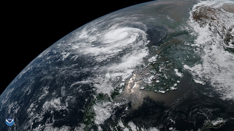
Why it matters. Cyclones are now among the deadliest hazards that India has learnt to manage well, which makes them a good example of preparedness working. Yet damage to homes, crops, fishing boats and power lines is still huge. Rising sea levels and warmer seas may make future cyclones and surges more dangerous.
Landslides: when slopes give way
A landslide is the sudden movement of rock, soil and debris down a slope under gravity. Every slope is held in place by the strength of its rock and soil, by friction and by the roots of plants. When the force pulling material downhill becomes greater than these holding forces, the slope fails.
Several conditions make a slope unstable. Steep slopes, weak or broken rock, and loose soil are natural causes, while water is the most common trigger. Heavy rain soaks into the soil, makes it heavy and slippery, and reduces friction, so most landslides in India happen during the monsoon.
Earthquakes can also shake loose large masses of rock. People add to the risk by cutting slopes for roads and buildings, removing the support at the foot of a hill, and by clearing forests, whose roots once bound the soil. Blocked natural drainage on hillsides adds to the danger.
In India, landslides are most common in the Himalaya, which are young, steep and earthquake-prone, and in the hills of the north-east. The steep, rain-soaked slopes of the Western Ghats and the Nilgiris are also badly affected. The plains and the old, stable plateaus face little risk.
Landslides can be reduced by mapping danger zones, avoiding construction on unstable slopes, building retaining walls and proper drainage, and planting trees and grasses on bare slopes. Early warning based on rainfall levels can help move people in time. On hill roads, careful design and slope protection save both lives and money.
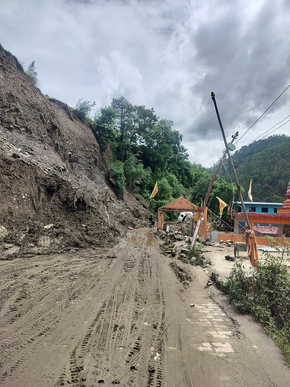
Why it matters. Landslides block highways and cut off whole valleys, isolating towns that depend on a single road. They also dam rivers, and when such natural dams burst, they cause sudden floods downstream. With more roads, dams and towns in the mountains, managing landslide risk has become central to development in hill regions.
Living with hazards: from relief to readiness
The four hazards in this chapter are different, but they share some lessons. First, they are linked: a cyclone brings floods, heavy rain triggers landslides, and deforestation worsens both floods and droughts. A hazard in one place often causes a chain of effects in another.
Second, vulnerability decides the damage. Two villages hit by the same flood can suffer very differently, depending on where houses stand, how they are built and whether people were warned. That is why reducing poverty, enforcing building rules and planning land use are part of disaster management.
Third, warning saves lives. Satellites, weather radars and river gauges now give hours or days of warning for cyclones and floods. The weakest link is often the last step, which is getting the warning to every village and making sure people know where to go.
Fourth, climate change is raising the stakes. Warmer air holds more moisture, so extreme rain events are becoming more frequent, while dry spells between them grow longer. Rising seas make storm surges reach farther inland.
India's approach has therefore shifted from giving relief after a disaster to reducing risk before it. How this is organised through law and institutions, along with earthquakes and tsunamis, is covered in earthquakes and disaster management.
Why it matters. Disasters can wipe out years of development in a few hours. Every rupee spent on preparation saves many rupees in relief and rebuilding. Seeing hazards as a development issue, not just a natural event, is the key idea examiners look for.
Mains lens: what, why, where and so what
UPSC Mains asks about disasters in GS Paper I (geography of hazards) and GS Paper III (disaster management). Here are four angles that connect this chapter to those questions.
1. Physical causes and human amplifiers. Every hazard has a natural trigger, but human action often magnifies it: silted rivers and encroached flood plains for floods, groundwater over-use for droughts, road cutting for landslides and mangrove loss for cyclones. Good answers show both sides.
2. Flood and drought in the same country. India's monsoon is concentrated and variable, so floods in the Ganga–Brahmaputra plains and drought in the rain-shadow interior can occur in the same year. Answers can link this to water storage, inter-basin transfer debates and watershed management.
3. The cyclone success story. Deaths from cyclones on the east coast have fallen sharply thanks to better forecasting, shelters and evacuation, but economic losses remain high. Use this as an example of preparedness and community warning systems, and point out the remaining gaps such as housing, power and fisheries.
4. Mountains under pressure. More roads, hydropower and tourism in the Himalaya and Western Ghats raise landslide and flash-flood risk. Answers should balance development with slope safety, environmental impact assessment and carrying capacity.
Mains lens: practice questions and answer plans
Now turn this understanding into written answers. The four questions below are written in the UPSC style, but they are our own practice questions, not previous-year questions. The real previous-year questions of your exam appear in the "Previous year questions" box once we have matched them with the official papers.
Q1. "Floods in the Ganga–Brahmaputra plains are as much man-made as natural. Discuss." (250 words)
- Introduction: Name the plains as India's most flood-prone region and give the share of flood-prone land.
- Body: First give the natural causes, such as monsoon rain, Himalayan silt and shifting rivers like the Kosi. Then give the human causes, such as deforestation, encroachment of flood plains and wetlands, and embankment failures.
- Conclusion: Argue for living with floods through warnings, zoning and catchment care.
Q2. "Distinguish between meteorological, hydrological and agricultural drought. Suggest measures to reduce drought vulnerability in India." (150 words)
- Define each type, with the 75% rainfall rule for meteorological drought.
- Then name the drought-prone regions.
- After that, give measures: watershed development, micro-irrigation, millets, insurance and groundwater regulation.
Q3. "Why is the east coast of India more prone to cyclones than the west coast? How has India reduced cyclone deaths?" (150 words)
- Explain the warmer Bay, the remnant storms from the Pacific and the low deltas.
- Next, describe storm surges.
- Close with warnings, shelters, evacuation and mangroves.
Q4. "Landslides in the Himalaya are increasing. Examine the causes and suggest remedies." (150 words)
- Give the natural causes: young, steep and weak rocks, earthquakes and monsoon rain.
- Then give the human causes: road cutting, deforestation and construction.
- Finally, suggest zoning, drainage, retaining walls and early warning.
Useful keywords: hazard, disaster, vulnerability, risk, flash flood, cloudburst, flood plain zoning, sorrow of Bihar, meteorological drought, hydrological drought, agricultural drought, drought-prone area, watershed, storm surge, landfall, cyclone shelter, landslide zonation, early warning.
Quick revision
- A hazard is a natural event that can cause harm; it becomes a disaster when losses exceed what people can cope with, and vulnerability decides how bad it gets.
- About 40 million hectares (about 12%) of India is flood-prone; the Brahmaputra and Ganga plains, especially Assam and Bihar, are the worst hit.
- The Kosi is the "sorrow of Bihar" because of its silt and shifting course.
- Meteorological drought means rainfall below 75% of normal; drought is also hydrological and agricultural.
- Drought-prone areas have a drought probability above 20%, and chronic drought-prone areas above 40%; the arid west and the rain-shadow peninsula are the most affected.
- Cyclones hit in April–May and October–December; the Bay of Bengal produces more, so the east coast is more exposed.
- The storm surge causes most cyclone deaths; IMD New Delhi tracks and names north Indian Ocean cyclones.
- Landslides hit the Himalaya, the north-east, the Western Ghats and the Nilgiris, mostly in the monsoon.