Paper II, Part B: General Knowledge · Regional Geography of India—Climate, Natural vegetation. Mineral and Power resources; location and distribution of agricultural and Industrial activities.
UPSC NDA & NA questions from this module are being sorted into our bank.
Cut to basic depth for UPSC NDA & NA. 21 deeper paragraphs are in the full chapter.
Start from zero: why location matters
Imagine describing your house to someone who has never seen it. You would tell them where it is, how big it is and who lives next door. A country can be described in the same way: by its location, its size and its neighbours.
India at a glance
These three facts shape almost everything else about a country. Location decides its climate, its seasons and its sea routes. Size decides how varied its land, people and resources can be, and neighbours decide its trade, its security and its culture.
India is a large country in South Asia, lying wholly in the Northern Hemisphere. Its area is about 3.28 million sq km, about 2.4% of the world's land area, which makes it the seventh largest country in the world. Yet it is home to a much larger share of the world's people, which puts heavy pressure on its land and water.
India also has a special place on the world map. It sits in the middle of the Indian Ocean rim, between the oil-rich lands of West Asia and the busy economies of East and South-East Asia. The Indian Ocean is the only ocean in the world named after a country.
Why it matters. India's location gives it a monsoon climate, a long coastline and a central position on the world's busiest sea routes. Its large size gives it great variety in landforms, climates, soils and cultures. Every later chapter on India's geography builds on these basic facts.
Where exactly is India? Latitude and longitude
To fix any place on the earth, we use two sets of imaginary lines. Latitudes run east–west and tell us how far north or south of the equator a place is. Longitudes run north–south and tell us how far east or west of the Prime Meridian at Greenwich a place is.
India's latitude and longitude extent
The mainland of India lies between about 8°4′N and 37°6′N latitude, and between about 68°7′E and 97°25′E longitude. So the whole country lies north of the equator and east of Greenwich. The southern part is quite close to the equator, while the north reaches well into the middle latitudes.
The Tropic of Cancer (23°30′N) runs across the middle of the country and divides it into almost two equal halves. It passes through eight states: Gujarat, Rajasthan, Madhya Pradesh, Chhattisgarh, Jharkhand, West Bengal, Tripura and Mizoram. A simple way to remember them is to trace the line from west to east on a map.
The part of India south of the Tropic of Cancer lies in the tropical zone, where the sun is overhead at noon at least once a year and it stays warm all year. The part to the north lies in the subtropical and temperate belt, where winters are cold and summers are hot. Even so, the whole country shares a monsoon climate, because the Himalaya shield it from the cold winds of Central Asia.
Why it matters. Latitude explains why Kerala is warm all year while Kashmir has snowy winters. It also explains why day length changes more in the north than in the south. Exams often test the states on the Tropic of Cancer and the extreme latitudes and longitudes.
How big is India? Size, extent and time
India is a big country by any measure. From north to south it stretches about 3,214 km, and from east to west about 2,933 km. Interestingly, both the latitude and the longitude extent are about 30°, yet the north–south distance is greater, because the distance between longitudes shrinks as we move away from the equator.
India's size in numbers
India's land boundary is about 15,200 km long. Its coastline, including the islands, is about 7,516.6 km long, facing the Arabian Sea to the west, the Bay of Bengal to the east and the Indian Ocean to the south. This long coastline gives India many ports, rich fishing grounds and a large share of the sea's resources.
A wide spread of longitude also affects time. The earth turns 360° in 24 hours, so every 15° of longitude makes a difference of one hour in local time. Since India spans about 30° of longitude, the sun rises about two hours earlier in Arunachal Pradesh in the east than in Gujarat in the west.
To avoid confusion, the whole country follows a single Indian Standard Time (IST). It is taken from the 82°30′E meridian, which passes near Mirzapur in Uttar Pradesh. IST is 5 hours 30 minutes ahead of Greenwich Mean Time.
Longitude, local time and IST
A single time zone keeps railways, offices and broadcasts simple across the nation. However, the north-east sees daylight much earlier than the clocks suggest, and offices there lose useful morning hours. This is why some people have suggested a separate time zone for the north-east.
Why it matters. India's size gives it great variety, from snowy mountains to deserts and tropical coasts, and it allows the country to grow many kinds of crops. Its long coastline brings trade and fisheries but also exposes it to cyclones and tsunamis. The debate on time zones shows how geography affects daily life and governance.
India's neighbours
India shares land borders with seven countries. Pakistan and Afghanistan lie to the north-west, China, Nepal and Bhutan to the north, and Myanmar and Bangladesh to the east. Across the sea to the south lie the island nations of Sri Lanka and the Maldives.
India and its neighbours
The longest land border is with Bangladesh, about 4,096 km, which wraps around that country on three sides. Next come China (about 3,488 km) and Pakistan (about 3,323 km), and then Nepal, Myanmar and Bhutan. The shortest border is with Afghanistan, only about 106 km.
India's longest and shortest land borders
Sri Lanka is separated from India by a narrow stretch of sea made up of the Palk Strait and the Gulf of Mannar. A chain of shoals called Adam's Bridge or Ram Setu lies between them. The Maldives lie to the south-west, south of the Lakshadweep Islands.
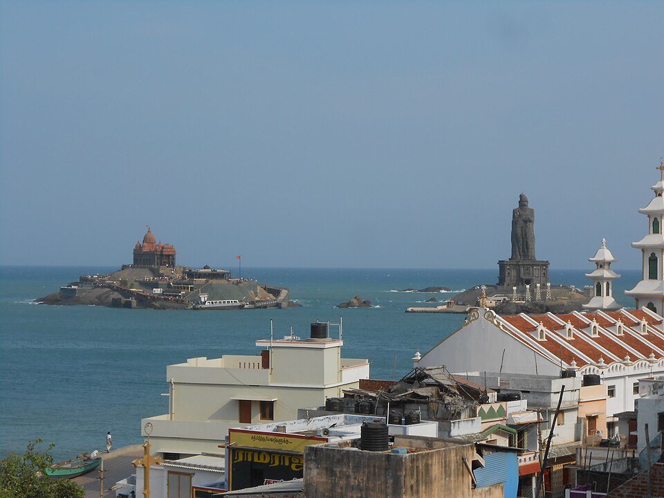
Kanyakumari, where three seas meetPhoto: Jdmn, CC BY-SA 4.0, via Wikimedia Commons
India's mainland ends at Kanyakumari in Tamil Nadu, where the Arabian Sea, the Bay of Bengal and the Indian Ocean meet. But the southernmost point of the country is Indira Point in the Great Nicobar Island, much further south.
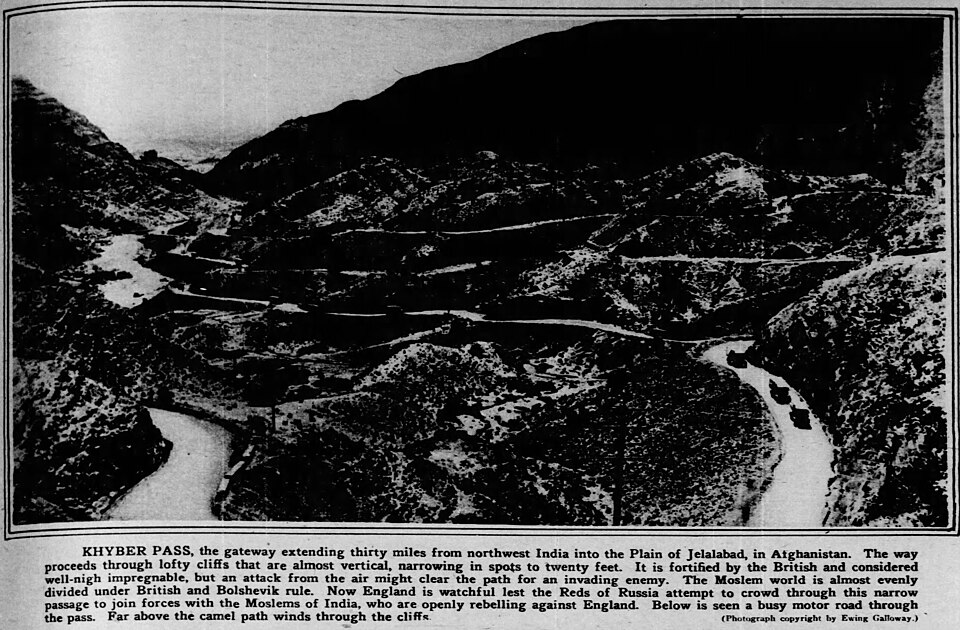
The Khyber PassPhoto: Ewing Galloway, Public domain, via Wikimedia Commons
Though high mountains and seas surround the subcontinent, they have never cut it off completely. Mountain passes in the north-west, such as the Khyber and the Bolan, brought traders, armies and ideas from Central and West Asia. Sea routes carried Indian goods, religions and art to South-East Asia, East Africa and the Arab world.
Why it matters. India's neighbours share its rivers, its monsoon, its cultures and many of its security challenges. Long and often disputed borders call for careful management and good relations. Shared rivers such as the Ganga, the Brahmaputra and the Indus make water cooperation a key part of India's foreign policy.
Quick revision
Mainland India: 8°4′N–37°6′N and 68°7′E–97°25′E; wholly in the Northern and Eastern Hemispheres.
The Tropic of Cancer crosses 8 states: Gujarat, Rajasthan, Madhya Pradesh, Chhattisgarh, Jharkhand, West Bengal, Tripura, Mizoram.
Area about 3.28 million sq km (2.4% of world land), 7th largest country.
3,214 km north–south, 2,933 km east–west; land border about 15,200 km, coastline about 7,516.6 km with islands.
IST is based on 82°30′E (near Mirzapur), 5 h 30 min ahead of GMT; sunrise in Arunachal is about two hours earlier than in Gujarat.
Seven land neighbours; longest border with Bangladesh, shortest with Afghanistan.
Palk Strait and Gulf of Mannar separate Sri Lanka; Ten Degree Channel separates the Andaman and Nicobar groups.
Kanyakumari is the mainland's southern tip; Indira Point is the country's southernmost point.
Exam-style questions on this chapter. Pick an answer to see the explanation. 0 of 8 answered
The Tropic of Cancer does NOT pass through which of the following states?
India's share of the world's land area is about:
Consider the following statements:
1. Indian Standard Time is based on the 82°30′E meridian.
2. Indian Standard Time is 4 hours 30 minutes ahead of GMT.
Which of the statements given above is/are correct?
With which country does India share its longest land border?
The southernmost point of India is:
The Andaman group of islands is separated from the Nicobar group by the:
Consider the following statements:
1. The Palk Strait lies between India and Sri Lanka.
2. The Gulf of Mannar lies between India and Sri Lanka.
Which of the statements given above is/are correct?
The north–south extent of India is greater than its east–west extent even though both span about 30°, because:
Previous year questions
Previous year questions for UPSC CSE will appear here once each one is checked word for word against the official question paper.
Frequently asked questions
Which states does the Tropic of Cancer pass through?
Eight states: Gujarat, Rajasthan, Madhya Pradesh, Chhattisgarh, Jharkhand, West Bengal, Tripura and Mizoram.
What is the north-south and east-west extent of India?
About 3,214 km from north to south and about 2,933 km from east to west.
Which country shares India's longest land border?
Bangladesh, at about 4,096 km, followed by China and Pakistan.
Why is there a two-hour time gap across India?
India spans about 30° of longitude, and local time changes 4 minutes per degree, so the Sun rises about two hours earlier in Arunachal than in Gujarat. One Standard Time on 82°30′E is used for the whole country.