Paper II, Part B: General Knowledge · The Earth, its shape and size. Latitudes and Longitudes, Concept of time. International Date Line. Movements of Earth and their effects.
UPSC NDA & NA questions from this module are being sorted into our bank.
Cut to basic depth for UPSC NDA & NA. 11 deeper paragraphs are in the full chapter.
Start from zero: weather, climate and why we group climates
Weather is the state of the atmosphere at a place on a given day, hot or cold, wet or dry, calm or windy. Climate is the average weather of a place over a long time, usually 30 years or more. Delhi may have a cool rainy day in May, but its climate is still one of hot summers.
Weather versus climate, and three ways to classify climates
There are thousands of weather stations on Earth, and no two have exactly the same climate. To make sense of them, geographers classify climates into a few types, so that places with similar temperature and rainfall patterns fall into one group. A good classification helps us predict what crops will grow, what houses people need and what natural vegetation will appear.
There are three broad ways to classify climates. The empirical method uses observed data, mainly temperature and rainfall. The genetic method groups climates by their causes, such as air masses and pressure belts, while the applied method serves a particular purpose, such as farming or building.
Why it matters. Climate types explain the global pattern of vegetation, soils, farming and settlement. They are the base for every chapter on world regions.
Köppen's scheme: five letters for the world
The most widely used classification was developed by the German climatologist Wladimir Köppen. He noticed that natural vegetation closely follows climate, so he chose temperature and rainfall limits that match the boundaries of major vegetation types. His scheme is empirical, based on monthly mean temperature and precipitation.
Köppen's groups A to E, with H for highlands
Köppen used five capital letters for five major climate groups. A is the tropical humid group, where every month averages above 18 °C. B is the dry group, where evaporation exceeds precipitation, and C is the warm temperate or mid-latitude group, with mild winters.
D is the cold snow-forest group, with severe winters and at least one month below about −3 °C, found only in the Northern Hemisphere because the Southern Hemisphere has little land at those latitudes. E is the cold or polar group, where even the warmest month stays below 10 °C, too cold for trees. A sixth letter, H, was later added for highland climates, which change with altitude.
The idea of matching climate with vegetation makes the scheme easy to use on a map. Tropical rainforests, deserts, temperate grasslands, coniferous forests and tundra each fall neatly into Köppen's groups.
Why it matters. Köppen's letters are a shorthand used in textbooks and exams across the world. Knowing them lets you read any world climate map at a glance.
Reading the small letters: the main climate types
Small letters add detail about the season of rainfall. f means rain in all months with no dry season, m means a monsoon pattern with a short dry season, w means a dry winter and s means a dry summer. So Af is the tropical wet climate of the Amazon and Congo basins and Indonesia, Am is the tropical monsoon climate of places like the west coast of India, and Aw is the tropical savanna climate of East Africa and much of interior India.
Köppen climate groups of the world
The dry group divides into BW, true desert such as the Sahara, Kalahari and Thar, and BS, semi-arid steppe on desert margins. A third letter, h for hot or k for cold, separates low-latitude deserts from mid-latitude ones such as the Gobi.
Among warm temperate climates, Cs is the famous Mediterranean climate, with dry summers and wet winters, found around the Mediterranean Sea, in California, central Chile, the Cape region of South Africa and south-western Australia. Cfa is the humid subtropical climate of eastern China and the south-eastern United States, while Cfb is the marine west coast climate of Britain and north-western Europe, mild and wet all year. Cwa, with dry winters, covers much of the Ganga plain.
Small letters and the climate types they make
In the cold groups, Df and Dw cover the vast snow forests of Siberia and Canada, with Dw in north-eastern Asia where winters are very dry. The polar group divides into ET, the tundra, where mosses and lichens grow in a short summer, and EF, the ice cap of Greenland and Antarctica.
Why does the Mediterranean climate sit on west coasts between about 30° and 40° latitude? In summer, the subtropical high-pressure belt shifts towards the pole with the Sun and covers these coasts, bringing dry, sinking air and clear skies. In winter, the belt moves back towards the equator, and the rain-bearing westerlies and their cyclones reach these coasts, bringing winter rain.
Western margin, interior and eastern margin at the same latitude
There is a second, older way to read the world map of climates, by position on the continent. At the same latitude, the western margin, the interior and the eastern margin of a continent get different winds, so they get different climates. In the warm temperate belt, roughly 30° to 45°, the western margin is Mediterranean, the dry interior is steppe and the eastern margin is the wet-summer China type, with its versions called the Gulf type in the south-eastern United States and the Natal type in south-eastern Africa, south-eastern Australia and the Paraná basin.
In the cool temperate belt, roughly 45° to 65°, the western margin is the mild, wet British (west European) type, the interior is the bitterly cold Siberian type with taiga forest, and the eastern margin is the Laurentian type of north-eastern North America, north-eastern China, Korea and northern Japan. Verkhoyansk in Siberia is among the coldest inhabited places in the Northern Hemisphere. Off Newfoundland, the warm Gulf Stream meets the cold Labrador Current, causing thick fog and creating the rich fishing grounds of the Grand Banks.
Mediterranean local winds and the Grand Banks
The Mediterranean lands also have famous local winds. The cold Mistral blows down the Rhone valley in southern France, and the cold Bora blows along the Adriatic coast. The hot, dry, dusty Sirocco blows north from the Sahara and is called the Khamsin in Egypt.
Why it matters. The small letters explain why places at the same latitude can have very different farming and vegetation. The Mediterranean pattern, for example, explains why citrus fruits and grapes grow on west coasts.
Climate has always changed
Climate is not fixed. Over millions of years, Earth has passed through long ice ages, when ice sheets covered much of North America and Europe, and warm periods when even polar regions were free of ice. The last major glaciation ended about ten thousand years ago, and since then the climate has been relatively warm, allowing farming and civilisations to grow.
Earth's climate through time
Evidence of past climates comes from many sources. Ice cores from Greenland and Antarctica trap tiny bubbles of ancient air, while tree rings, lake and ocean sediments, fossil pollen and coral layers record past temperatures and rainfall. Historical records of harvests, floods and droughts add detail for the last few thousand years.
Even in historical times, climate has shifted. The Thar region of Rajasthan was wetter several thousand years ago, with lakes and rivers that have since dried up. A warm period in medieval Europe was followed by a cooler phase known as the Little Ice Age, roughly from the mid-16th to the mid-19th century, when glaciers advanced and rivers such as the Thames sometimes froze.
How we read past climates
Why it matters. Knowing that climate changes naturally helps us see why today's change is different. Present warming is far faster than most natural shifts and is driven mainly by human activity.
Causes: natural factors and the greenhouse effect
Several natural factors change climate. The Sun's output varies slightly with sunspot activity, and periods with fewer sunspots have been linked with cooler conditions. Over tens of thousands of years, slow changes in the shape of Earth's orbit, the tilt of its axis and the wobble of the axis, called Milankovitch cycles, change how sunlight is spread over the globe and help trigger ice ages.
Natural causes of climate change
Large volcanic eruptions throw ash and sulphur aerosols high into the atmosphere, where they reflect sunlight and cool the Earth for a year or two. The eruption of Mount Pinatubo in the Philippines in 1991, for instance, lowered global temperatures noticeably for a short time.
The most important cause of present-day change is the greenhouse effect. Sunlight passes through the atmosphere and warms the surface, which sends heat back out as long-wave radiation. Greenhouse gases absorb part of this heat and send it back down, keeping the Earth about 33 °C warmer than it would otherwise be.
The main greenhouse gases are carbon dioxide, methane, nitrous oxide, chlorofluorocarbons and ozone, along with water vapour. Burning coal, oil and gas, cutting forests, rice paddies, cattle, fertilisers and some industrial gases have raised their concentration since the Industrial Revolution, strengthening the natural greenhouse effect.
Why it matters. Without the natural greenhouse effect, Earth would be frozen. The problem is the extra greenhouse effect caused by human emissions, which is warming the planet.
Global warming: evidence, effects and response
The Intergovernmental Panel on Climate Change (IPCC), set up in 1988, assesses the science of climate change. Its Sixth Assessment Report found that global surface temperature in 2011–2020 was about 1.1 °C higher than in 1850–1900, and that human influence has unequivocally warmed the atmosphere, ocean and land.
The greenhouse effect
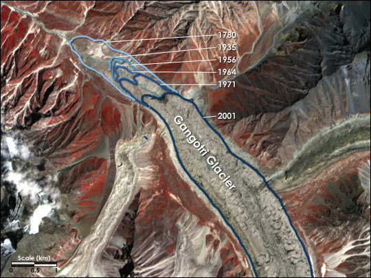
The effects are already visible. Mountain glaciers, including many in the Himalaya, are retreating, and Arctic sea ice is shrinking. Sea level is rising as ocean water warms and expands and as land ice melts, threatening low-lying coasts and island nations.
Effects of global warming
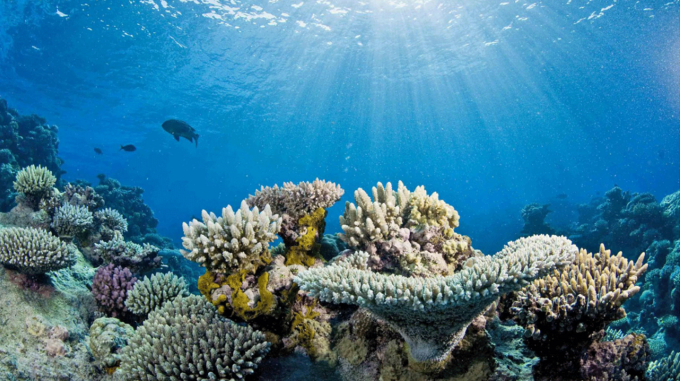
Heat waves have become hotter and more frequent, and very heavy rainfall events have increased in many regions, along with longer droughts in others. Climatic zones and crop belts are shifting towards the poles and to higher altitudes, and coral reefs suffer bleaching in warmer seas.
Climate agreements and India's plan
The world has responded through agreements. Under the United Nations Framework Convention on Climate Change (1992), the Kyoto Protocol of 1997, which came into force in 2005, set binding targets for developed countries. The Paris Agreement of 2015 aims to keep warming well below 2 °C and to pursue efforts to limit it to 1.5 °C, with every country setting its own targets, called nationally determined contributions.
A retreating Himalayan glacierPhoto: NASA Earth Observatory, Public domain, via Wikimedia Commons
India argues for common but differentiated responsibilities, since developed countries emitted most of the carbon already in the atmosphere, while India's emissions per person remain far below the world average. At home, the National Action Plan on Climate Change of 2008 set up national missions on solar energy, energy efficiency, water, the Himalayan ecosystem, green India, sustainable agriculture, sustainable habitat and strategic knowledge. India has also announced a goal of reaching net-zero emissions by 2070.
Why it matters. India is highly vulnerable to heat, floods, droughts and sea-level rise. Climate change links geography with energy, agriculture, disaster management and international relations.
Quick revision
Climate = average weather over about 30 years or more.
Classification methods: empirical, genetic, applied; Köppen is empirical and vegetation-based.
By position (same latitude): warm temperate = Mediterranean (west), steppe (interior), China/Gulf/Natal (east); cool temperate = British (west), Siberian (interior), Laurentian (east).
A tropical humid (every month above 18 °C); B dry; C warm temperate; D cold snow-forest (Northern Hemisphere only); E polar (warmest month below 10 °C); H highland.
f no dry season; m monsoon; w dry winter; s dry summer.
Cs = Mediterranean (dry summer, wet winter) on west coasts about 30°–40°.
BW desert, BS steppe; ET tundra, EF ice cap.
Little Ice Age: roughly mid-16th to mid-19th century.
Exam-style questions on this chapter. Pick an answer to see the explanation. 0 of 11 answered
Köppen's classification of climates is primarily:
In Köppen's scheme, the letter "s" in Cs indicates:
Consider the following statements about Köppen's climate groups:
1. In group A, every month has a mean temperature above 18 °C.
2. Group D is found in both hemispheres.
Which of the statements given above is/are correct?
The Mediterranean (Cs) type of climate is found in which of the following regions?
1. Central Chile
2. South-western Australia
3. The Cape region of South Africa
Select the correct answer:
A large volcanic eruption usually affects global temperature by:
Milankovitch cycles refer to:
Consider the following statements:
1. The Kyoto Protocol set binding emission targets for all countries, developed and developing.
2. The Paris Agreement aims to keep warming well below 2 °C and to pursue 1.5 °C.
Which of the statements given above is/are correct?
In Köppen's classification, ET stands for:
The "Little Ice Age" refers roughly to the period:
Match the cool temperate climate type with its position on the continent:
A. British type — 1. Interior
B. Siberian type — 2. Eastern margin
C. Laurentian type — 3. Western margin
Which of the following is the correct match?
Which of the following local winds is hot?
Previous year questions
Previous year questions for UPSC CSE will appear here once each one is checked word for word against the official question paper.
Frequently asked questions
What does 'f', 'm', 'w' and 's' mean in Köppen's scheme?
f means no dry season, m monsoon with a short dry season, w a dry winter and s a dry summer.
Which climate is Mediterranean in Köppen's scheme?
Cs is the Mediterranean climate: hot dry summers and mild wet winters, found on the western sides of continents around 30° to 40° latitude.
What are the three methods of classifying climate?
Empirical (based on observed temperature and rain, like Köppen), genetic (based on causes such as air masses), and applied (for a specific purpose such as farming).
Has the Earth's climate changed before humans?
Yes. Ice ages and warm periods came and went because of changes in Earth's orbit, volcanic eruptions and solar output. Today's warming is faster and driven mainly by greenhouse gases from human activity.