

KPSC KAS · Module 15 · Mains depth · 15 min
ಹರಿಯುವ ನೀರು ಮತ್ತು ಅಂತರ್ಜಲದಿಂದ ರೂಪುಗೊಂಡ ಭೂರೂಪಗಳು
What KPSC KAS asks from this chapter
Syllabus lines this chapter covers:
- Paper I: General Studies · ಕರ್ನಾಟಕಕ್ಕೆ ಒತ್ತು ನೀಡಿ ವಿಶ್ವ ಮತ್ತು ಭಾರತದ ಭೂಗೋಳ.
- GS 2 · ಭಾರತ ಮತ್ತು ಕರ್ನಾಟಕದ ಭೌತಿಕ ಲಕ್ಷಣಗಳು ಮತ್ತು ನೈಸರ್ಗಿಕ ಸಂಪತ್ತು.
4 KPSC KAS questions in our bank come from this module (ಶಿಲೆಗಳು, ಫಲಕಗಳು ಮತ್ತು ಭೂರೂಪಗಳು).
Read at full depth: basics, the standard layer and the Mains analysis.
Start from zero: the river as a sculptor
Watch a stream after heavy rain and you will see it is brown with mud and grinding pebbles along its bed. Every river does this, day after day, for thousands and millions of years. Slowly it carves valleys, cuts gorges through mountains and builds plains and deltas where it slows down.
Running water is the most widespread shaper of land on Earth, working everywhere except where it is too dry or too cold. Rain falls on hills, gathers into rills and streams, and joins rivers that carry rock debris towards the sea.
Water also works below the ground. Rainwater that soaks into rocks, called groundwater, can dissolve some rocks and hollow out caves, sinkholes and strange landscapes.
Why it matters. Most people live on land shaped by rivers: floodplains, deltas and river terraces. River landforms decide where we farm, build cities, place bridges and dams, and where floods and erosion are a risk.
How rivers erode, carry and deposit
A river does three jobs: erosion, transport and deposition. Which job dominates depends on its energy, which comes from the volume of water and the slope. Fast, full rivers erode and carry; slow rivers drop their load.
Rivers erode in four ways. Hydraulic action is the sheer force of moving water loosening and removing material. Abrasion (corrasion) is the grinding of the bed and banks by pebbles and sand carried in the water, like sandpaper.
Attrition is the knocking together of the pebbles themselves, which makes them smaller and rounder downstream. Solution (corrosion) dissolves soluble rocks such as limestone.
The material a river carries is its load. Heavy boulders and pebbles are rolled and bounced along the bottom as bed load. Fine silt and clay float in the water as suspended load, which makes rivers look muddy, and dissolved minerals form the invisible dissolved load.
When the river slows, for example on entering a plain, a lake or the sea, it drops its load in order of size: the biggest pieces first and the finest last. This sorting is why river deposits form layers of gravel, sand, silt and clay.
Why it matters. The huge suspended load of Himalayan rivers builds the fertile Northern Plains and deltas, but also fills reservoirs with silt and raises riverbeds, worsening floods. Understanding river energy guides dam design, embankments and sand mining rules.
The upper course: valleys, gorges and waterfalls
Near its source in the hills, a river has a steep slope and little water, but great energy for cutting down. It deepens its bed faster than it widens it, carving a narrow V-shaped valley. Weathering and mass movement on the valley sides give the "V" its sloping walls.
Where the river cuts through hard rock, or the land is rising, the valley becomes a gorge, a deep valley with very steep, almost vertical sides. A canyon is a special kind of gorge, wider at the top with step-like sides, formed in dry regions with horizontal layers of rock; the Grand Canyon of the Colorado is the classic example. Himalayan rivers such as the Indus, Sutlej and Brahmaputra have cut deep gorges as the mountains rose.
Waterfalls form where a river flows over a band of hard rock on top of softer rock, or over a fault or cliff. The soft rock below is worn away, the hard layer overhangs and collapses, and the fall slowly retreats upstream, leaving a gorge. At its foot, the falling water and swirling stones dig a deep plunge pool. Rapids form where the bed is uneven and the water tumbles over rocks.
In rocky beds, pebbles caught in swirling eddies drill round holes called potholes. On bare slopes, especially where vegetation is cleared, rainwater cuts small rills that deepen into gullies; a dense network of gullies creates badlands, such as the ravines of the Chambal valley.
Where a mountain stream suddenly reaches flat land, its speed drops sharply and it dumps its coarse load in a fan-shaped alluvial fan or cone. Many such fans along the Himalayan foothills merge into a belt of porous gravel where streams sink underground.
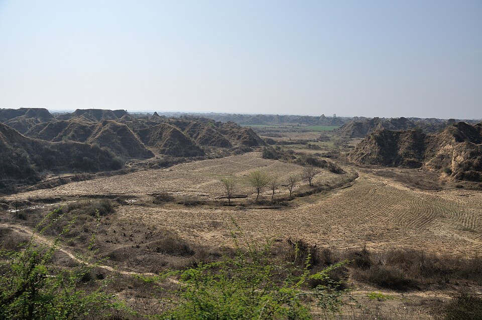
Why it matters. Gorges offer dam sites and hydropower, while waterfalls draw tourists. Gully erosion and badlands destroy farmland, so ravine reclamation through check dams and tree planting is a major soil conservation task.
The middle and lower course: meanders, floodplains and deltas
As a river reaches gentler land, it stops cutting down and starts swinging sideways. It develops loops called meanders. On the outside of each bend the water is fast and erodes the bank into a steep river cliff, while on the inside it is slow and deposits sand as a gentle point bar.
Over time, meanders grow larger and their necks narrow. During a flood, the river may cut straight across a neck, leaving the old loop cut off as a curved oxbow lake. The plains of the Ganga and its tributaries are dotted with such lakes.
When a river floods, it spreads silt over the flat land on either side, building a floodplain. The coarsest material is dropped right beside the channel, so over many floods it builds raised banks called natural levees. When a river carries more load than it can handle, as many Himalayan rivers do, it splits into many shifting channels around sandbars, forming a braided river, like the Brahmaputra in Assam.
If the land rises or sea level falls, the river cuts down into its own floodplain, leaving the old floodplain as a step-like river terrace along the valley side. Terraces are good sites for villages and fields above the reach of floods.
At its mouth, a river carrying a heavy load into a calm sea with weak tides builds a delta, a flat triangle of new land crossed by many distributaries. The Ganga–Brahmaputra delta is the largest in the world, and the Mahanadi, Godavari, Krishna and Kaveri build deltas on India's east coast. Where tides are strong and sweep the sediment away, or the coast is sinking, the river ends in a funnel-shaped estuary instead, as the Narmada and Tapi do on the west coast.
Every river works towards its base level, the lowest level to which it can cut, which for most rivers is the sea. A river that has balanced its slope, water and load so that it neither cuts down nor builds up is called graded. If the land is uplifted or sea level falls, the river gains new energy and starts cutting down again, which is called rejuvenation. Its signs are knickpoints (sudden breaks in the long profile, often with waterfalls), river terraces and deeply incised meanders, like the winding gorges of some Peninsular rivers.
Why it matters. Floodplains and deltas are among the most fertile and crowded places on Earth, but they flood regularly and are now threatened by sea-level rise and reduced sediment from dams. Rivers shifting course, like the Kosi, show why floodplain zoning matters.
Groundwater and karst landscapes
Some rainwater soaks into the ground and fills the pores and cracks of rocks as groundwater. Rocks that hold and pass water easily, such as sandstone and gravel, are permeable; clay and shale are not. Where the water table meets the surface, groundwater flows out as springs.
In most rocks groundwater does little shaping. But in limestone and dolomite, rainwater containing carbon dioxide acts as weak carbonic acid and slowly dissolves the rock along its joints. The distinctive landscapes formed this way are called karst, after the Karst plateau of Slovenia, where they were first studied.
On the surface, solution etches the bare rock into grooves and sharp ridges called lapies or karren. Funnel-shaped hollows called sinkholes or dolines form where water drains down or a cave roof collapses. Several sinkholes may merge into a larger uvala, and very large, flat-floored depressions are called poljes.
Surface streams in karst often vanish down swallow holes and flow through underground channels, leaving dry valleys above. They re-emerge as large springs where the limestone meets impermeable rock. As a result, karst areas can have plenty of rain but little surface water.
Why it matters. Karst aquifers supply water to millions worldwide but are easily polluted, because water flows quickly through open channels without filtering. Sinkholes can also swallow buildings and roads, so construction on limestone needs careful surveys.
Caves and cave deposits
Below the surface, slowly moving groundwater widens joints and bedding planes in limestone into passages and caves. Some cave systems run for hundreds of kilometres; the Mammoth Cave system in the United States is the longest known.
Water dripping from a cave roof loses some carbon dioxide into the cave air, so it can no longer hold all its dissolved calcium carbonate. It deposits tiny amounts of calcite, drop by drop, building icicle-like stalactites that hang from the roof. Where the drops land, more calcite builds stalagmites rising from the floor.
Over thousands of years, a stalactite and a stalagmite may meet and join as a pillar or column. These cave deposits, called speleothems, grow so slowly and regularly that scientists use their layers to reconstruct past rainfall and monsoon strength.
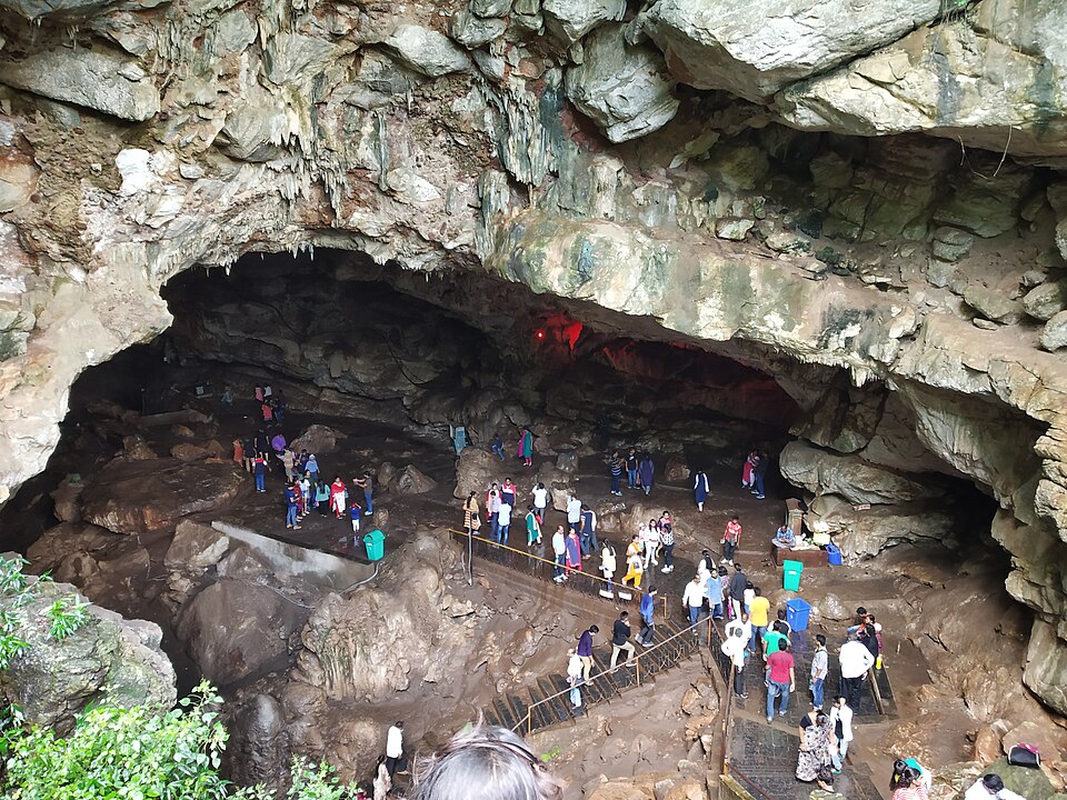
India has notable karst and caves in limestone areas. The Borra Caves in the Eastern Ghats are known for their speleothems, and the limestone hills of Meghalaya contain some of the longest cave systems in South Asia. Cave layers from the North-East have been used to study changes in the Indian monsoon over thousands of years.
Why it matters. Caves are fragile natural heritage and tourist attractions. Their deposits are valuable climate archives, which is why cave protection, limestone mining controls and groundwater care are linked issues.
Mains lens: what, why, where and so what
This chapter supports GS Paper I (geomorphology) and links to floods, agriculture and water in GS Paper III. Here are four angles.
1. Rivers through their course. Answers can trace erosion in the upper course, transport and meandering in the middle and deposition in the lower course, with Indian examples.
2. Floodplains and human use. Fertile floodplains and deltas attract dense settlement but face floods, channel shifts and sinking deltas. This supports arguments for floodplain zoning.
3. Badlands and soil loss. Gully erosion in the Chambal and other ravines destroys land and livelihoods; reclamation links geomorphology with rural development.
4. Karst and water security. Karst aquifers are productive but vulnerable to pollution and collapse, so mining and construction in limestone areas need regulation.
Mains lens: practice questions and answer plans
Now turn this understanding into written answers. The four questions below are written in the UPSC style, but they are our own practice questions, not previous-year questions. The real previous-year questions of your exam appear in the "Previous year questions" box once we have matched them with the official papers.
Q1. "Describe the erosional and depositional landforms produced by a river along its course." (250 words)
- Introduction: Explain river energy and the three courses.
- Body: Upper (V-valley, gorge, waterfall, pothole), foothills (alluvial fan), middle and lower (meander, oxbow, levee, floodplain, delta).
- Conclusion: Link to human use and floods.
Q2. "Why do some rivers form deltas while others form estuaries? Illustrate with Indian examples." (150 words)
- Compare load, tides, waves and coastal subsidence.
- Contrast east-coast deltas with the Narmada and Tapi estuaries.
Q3. "What is karst topography? Describe its main landforms." (150 words)
- Explain carbonation of limestone.
- Cover lapies, sinkholes, uvalas, poljes, swallow holes and caves with speleothems.
Q4. "Badlands are both a geomorphic and a socio-economic problem. Discuss with reference to India." (150 words)
- Explain gully formation.
- End with land loss and reclamation measures.
Useful keywords: base level, graded river, rejuvenation, incised meander, hydraulic action, abrasion, attrition, solution, bed load, suspended load, V-shaped valley, gorge, canyon, waterfall, plunge pool, pothole, rill, gully, badlands, alluvial fan, meander, point bar, oxbow lake, levee, floodplain, braided river, terrace, delta, estuary, karst, lapies, sinkhole, uvala, polje, stalactite, stalagmite.
Quick revision
- River erosion: hydraulic action, abrasion, attrition, solution. Load: bed, suspended, dissolved.
- Upper course: V-valley, gorge, canyon (dry, stepped), waterfall (retreats upstream), plunge pool, rapids, potholes.
- Rills → gullies → badlands (Chambal ravines). Alluvial fan where streams leave the hills.
- Middle/lower: meanders (erosion outside, point bar inside), oxbow lake, floodplain, levees, braided channels, terraces.
- Base level → graded river; uplift → rejuvenation (knickpoints, terraces, incised meanders).
- Mouth: delta (heavy load, calm sea; east coast) vs estuary (strong tides; Narmada, Tapi).
- Karst (limestone): lapies, sinkholes/dolines, uvala, polje, swallow holes, dry valleys, caves.
- Stalactites hang from the roof; stalagmites rise from the floor; they join as pillars.