

KPSC KAS · Module 16 · Mains depth · 21 min
ಸೂರ್ಯನ ಬೆಳಕು, heat budget ಮತ್ತು ತಾಪಮಾನ
What KPSC KAS asks from this chapter
Syllabus lines this chapter covers:
- Paper I: General Studies · ಕರ್ನಾಟಕಕ್ಕೆ ಒತ್ತು ನೀಡಿ ವಿಶ್ವ ಮತ್ತು ಭಾರತದ ಭೂಗೋಳ.
- GS 2 · ಭಾರತ ಮತ್ತು ಕರ್ನಾಟಕದ ಭೌತಿಕ ಲಕ್ಷಣಗಳು ಮತ್ತು ನೈಸರ್ಗಿಕ ಸಂಪತ್ತು.
KPSC KAS questions from this module are being sorted into our bank.
Read at full depth: basics, the standard layer and the Mains analysis.
Start from zero: why is the road hotter than the air?
Walk barefoot on a road on a May afternoon and your feet will burn, even though the air does not feel quite as hot. Touch a car parked in the sun and the metal is hotter still. Things that sit in sunlight get much hotter than the air around them.
This tells us something surprising about how the air is heated. Sunlight passes through the air without warming it much. It is the ground that soaks up the sunlight and becomes hot first.
The hot ground then gives off heat, and the air just above it warms up. That warm air rises and mixes with the air above, so the heat slowly spreads upwards. In short, the sun heats the ground, and the ground heats the air.
This simple idea explains many things we notice every day. It explains why heat shimmers above a road, why the air is warmest a little after noon rather than at noon, and why climbing a hill makes us feel cooler.
Keep three questions in mind as you read: How much of the sun's energy reaches us? How does it turn into the warmth of the air? And why are some places so much hotter or colder than others?
Why it matters. Temperature is the starting point of all weather. Differences in temperature create differences in pressure, those create winds, and winds carry the moisture that becomes rain. Heatwaves, frost and fog are also temperature events, so this chapter helps explain the weather that affects crops, health and transport.
Insolation: how much sunlight reaches a place
The energy that the Earth receives from the sun is called insolation, a short form of "incoming solar radiation". It arrives mostly as short waves, which pass easily through the air. Only a tiny part of the sun's total energy reaches the Earth, but that small share drives all weather and all life.
You might expect the Earth to be hottest when it is closest to the sun, but it does not work that way. The Earth is nearest to the sun on 3 January (about 147 million km) and farthest on 4 July (about 152 million km). The northern hemisphere still has its summer in July, which shows that distance from the sun is not what makes the seasons.
What matters more is the angle of the sun's rays. Shine a torch straight down on a table and you get a small, bright circle; tilt it and the same light spreads into a large, dim patch. Vertical rays work like the straight torch, so they heat a small area strongly, while slanting rays spread the same energy over a larger area.
Slanting rays also travel through a longer path of air, so more of their energy is scattered and absorbed on the way. This is why the tropics, where the sun is high, receive far more heat than the polar regions, where the sun stays low in the sky.
Three other things also change how much insolation a place gets. The length of the day matters, because a longer day gives more hours of sunshine. The transparency of the air matters, because clouds, dust and smoke block sunlight, and the slope of the land matters, because a slope that faces the sun gets more heat than one that faces away.
Why it matters. The uneven spread of insolation is the root cause of almost every climate pattern on Earth. It explains why the tropics are hot and the poles are cold, and why seasons change through the year. In the hills, it explains why the sunny slope is chosen for villages, orchards and tea gardens, while the shady slope stays forested.
How the air gets heated: from the ground up
Sunlight arrives as short waves, which the air lets through easily. The ground absorbs them, becomes warm and then gives off heat in a different form, as long waves. This outgoing heat from the Earth is called terrestrial radiation.
The air absorbs long waves much better than short waves, because gases like carbon dioxide and water vapour trap them. So the atmosphere is heated mainly from below, by the warm Earth, and only a little directly by the sun. This is the deeper reason why the air gets colder as we climb higher, away from the heated ground.
Heat moves from the ground into the air, and then within the air, in three ways. The first is conduction. The thin layer of air touching the hot ground warms up by direct contact, just as a pan warms when it touches a hot stove.
The second is convection. Warmed air becomes lighter, rises in columns and carries heat upward, while cooler air sinks to take its place. On hot afternoons, convection builds the tall clouds that bring thunderstorms.
The third is advection, the horizontal movement of air that carries heat from one place to another. In the middle latitudes, most day-to-day changes in weather come from advection, as warm or cold air arrives from somewhere else. In northern India, the loo of summer is a clear example, because hot, dry air is carried across the plains and raises the temperature wherever it goes.
Why it matters. These three processes explain how a local patch of heat becomes regional weather. Convection explains afternoon storms in the pre-monsoon months, and advection explains why a city can turn hot or cold within hours when the wind changes. Understanding them helps in reading weather forecasts and heat warnings correctly.
The heat budget: the Earth's energy account
Think of the Earth's energy like a household budget. Money comes in, money goes out, and if the two match every month, the savings stay the same. The Earth works the same way with heat: over a long period, it sends back to space as much energy as it receives, so its average temperature stays steady.
This balance is called the heat budget. To understand it, imagine that 100 units of insolation reach the top of the atmosphere. About 35 units are reflected back to space before they can heat anything, mostly by the tops of clouds, with smaller amounts scattered by the air and reflected by snow and ice.
This reflected share is called the Earth's albedo. Bright surfaces such as clouds, snow and ice reflect a lot, while dark surfaces such as forests and oceans absorb more. Of the remaining 65 units, about 14 are absorbed by the atmosphere and about 51 reach the ground and heat it.
The ground then gives this heat back. About 17 units escape directly to space, and about 34 units are absorbed by the atmosphere, carried up by direct radiation, by rising warm air and by the heat released when water vapour condenses into clouds. The atmosphere, now holding 14 plus 34, that is 48 units, finally radiates these 48 units to space.
Add up what leaves the Earth: 35 reflected, 17 from the ground and 48 from the atmosphere. The total is exactly 100, the same as what came in. The account balances, and that is why the Earth neither keeps heating up nor keeps cooling down.
The balance holds for the planet as a whole, but not for every latitude. Between about 40° N and 40° S the Earth gains more energy than it loses, so there is a surplus. Towards the poles it loses more than it gains, so there is a deficit.
If nothing moved this extra heat, the tropics would keep getting hotter and the poles colder. Instead, winds and ocean currents carry heat from the surplus zone towards the poles. This movement of heat is the main engine behind the planet's great wind belts and ocean currents.
Why it matters. The heat budget is the simplest way to explain climate change. When more greenhouse gases trap outgoing heat, less energy leaves than arrives, the account goes out of balance and the planet warms until a new balance is reached. Melting snow and ice make this worse, because a darker surface reflects less and absorbs more.
Why temperature differs from place to place
Delhi in May can be above 40°C while Mumbai on the same day stays far milder, and Leh is cooler than both. Several factors work together to decide the temperature of a place. The main ones are latitude, altitude, distance from the sea, air masses and ocean currents, and local factors.
Latitude decides the angle of the sun's rays, so places near the equator are generally warmer than places near the poles. Altitude matters because temperature falls with height in the lower atmosphere, so Shimla or Darjeeling stays cooler than the plains at the same latitude.
Distance from the sea matters because land heats and cools faster than water. Water needs more heat to warm up, lets sunlight go deeper and keeps mixing, so it changes temperature slowly. A coastal city like Mumbai therefore has mild summers and mild winters, while an inland city like Delhi has hot summers and cool winters.
The difference between the warmest and the coldest month is called the annual range of temperature. It is small near oceans and large deep inside big continents. The largest ranges in the world are found in north-eastern Eurasia, far from any warm ocean.
Air masses and ocean currents carry the temperature of one region into another. A warm current keeps a coast milder in winter, while a cold current cools the coast beside it. Local factors, such as slope, forest cover or a big city, can also shift the temperature of a small area by a few degrees.
On maps, temperature is shown with isotherms, lines that join places of equal temperature. Over the oceans they run fairly straight, but they bend sharply where land meets sea, because land and water heat so differently. This bending is one of the clearest signs, on any climate map, of the power of the land-sea contrast.
Why it matters. These factors explain why India's climate is so varied within one country, from the cold desert of Ladakh to the humid coast of Kerala. They also explain why inland plains face the worst heatwaves and cold waves, while coastal cities face humid heat instead. Planning for crops, housing and health must start from these local differences.
Temperature inversion: when the air gets warmer as you go up
Normally the air gets colder as we go up. But on some nights the opposite happens: the air near the ground is colder than the air a little higher up. This upside-down condition is called a temperature inversion.
An inversion forms most easily on long winter nights with clear skies and calm air. With no clouds to act as a blanket, the ground loses its heat quickly to space and becomes very cold. The air touching it cools too, while the air above stays relatively warm, and with no wind to mix the layers, the cold air stays trapped below.
In hills and mountains the effect is even stronger. At night, cold and heavy air slides down the slopes and collects in the valley floor, much like water flowing downhill. So the valley bottom can have frost while the slopes higher up stay a few degrees warmer.
This is why, in some hill areas, orchards and houses are placed on the middle slopes rather than on the valley floor, to escape the frost. The pool of cold air in valleys also explains why fog fills them on winter mornings.
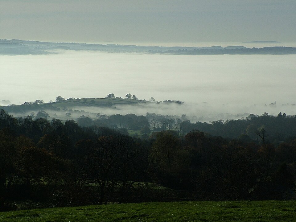
An inversion acts like a lid on the air. Warm air above stops the cold air below from rising, so smoke, dust and moisture cannot escape upwards. This is why winter mornings in the northern plains often bring thick fog and smog together.
Why it matters. Inversions turn a normal winter night into a public problem. They help cause dense fog that delays trains and flights, frost that damages crops such as potatoes and mustard, and smog that harms health. Knowing when an inversion is likely helps farmers protect crops, transport agencies plan for fog and cities warn people about bad air.
Mains ದೃಷ್ಟಿಕೋನ: ಏನು, ಏಕೆ, ಎಲ್ಲಿ ಮತ್ತು ಆಗ ಏನು
UPSC Mains (GS Paper I and III) rarely asks you only to define insolation or list the heat budget numbers. It asks why temperature patterns exist and what they mean for people and policy. Here are three angles that link this chapter to real issues.
1. A budget out of balance: the science behind global warming. The heat budget gives the cleanest explanation of climate change. Greenhouse gases trap more of the outgoing heat, so the Earth sends out less energy than it receives and warms until a new balance is reached. Shrinking snow and ice lower the albedo, so the planet absorbs even more sunlight.
In an answer, this mechanism lets you explain warming without jargon. It also shows why warming is uneven: polar regions, where ice is melting, are warming faster, and this changes the movement of heat by winds and ocean currents.
2. Heatwaves and the land-sea contrast (where heat hurts most). Inland plains heat and cool faster than coasts, and in summer hot air is carried across them by advection. This is why the worst heatwaves in India strike the inland north and centre, while coastal cities suffer humid heat that feels just as dangerous to the body. Cities add their own heat, because concrete and asphalt absorb sunlight and release it at night.
The implications run through health, labour and energy. Outdoor workers lose working hours, hospitals see more heat illness and electricity demand peaks as people use fans and coolers. Good answers suggest heat warnings, shaded public spaces, reflective roofs, more trees and changed working hours.
3. Inversions, fog and frost (when calm nights become costly). On calm, clear winter nights, inversions trap cold air, fog and pollution near the ground. In the northern plains this brings dense fog that disrupts trains, flights and road traffic, and it holds smog over cities for days. In the hills and plains, frost on such nights can damage sensitive crops.
The lesson for policy is that weather can turn emissions into a crisis. Clean-air plans, fog-safety systems for transport and frost warnings for farmers all depend on forecasting these calm, cold nights well in advance.
Mains lens: practice questions and answer plans
ಈಗ ಈ ತಿಳುವಳಿಕೆಯನ್ನು ಲಿಖಿತ ಉತ್ತರಗಳಾಗಿ ಬದಲಿಸುವ ಸಮಯ. ಕೆಳಗಿನ ನಾಲ್ಕು ಪ್ರಶ್ನೆಗಳು UPSC ಶೈಲಿಯಲ್ಲಿ ಬರೆಯಲ್ಪಟ್ಟಿವೆ, ಆದರೆ ಇವು ನಮ್ಮದೇ practice questions, previous-year questions ಅಲ್ಲ. ನಿಮ್ಮ ಪರೀಕ್ಷೆಯ ನಿಜವಾದ previous-year questions ಅನ್ನು ಅಧಿಕೃತ ಪತ್ರಿಕೆಗಳೊಂದಿಗೆ ಹೊಂದಿಸಿದ ನಂತರ "Previous year questions" ಬಾಕ್ಸ್ನಲ್ಲಿ ಕಾಣಿಸುತ್ತವೆ.
Q1. "Explain the heat budget of the Earth. How does an imbalance in it lead to global warming?" (250 words)
- Introduction: Define insolation and the heat budget as the balance between energy received and energy returned.
- Body: Walk through the 100 units: 35 reflected, 14 absorbed by the air, 51 by the ground; then 17 from the ground and 48 from the atmosphere to space. Add the latitudinal surplus and deficit and the role of winds and ocean currents.
- Imbalance: Explain how more greenhouse gases and less snow and ice upset the balance.
- Conclusion: Say that restoring the balance needs lower emissions, and that adaptation is needed for the warming already under way.
Q2. "The atmosphere is heated from below. Explain, and show how this affects the vertical distribution of temperature." (150 words)
- Begin with short-wave insolation and long-wave terrestrial radiation.
- Then explain conduction, convection and advection with Indian examples.
- After that, link heating from below to the fall of temperature with height.
- End with the exception of temperature inversion.
Q3. "What is temperature inversion? Discuss its effects on agriculture, transport and air quality in north India." (150 words)
- Define inversion and give the conditions: long nights, clear skies and calm air.
- Then explain cold-air drainage in valleys and frost.
- After that, describe the effects: fog and delays, crop damage and trapped smog.
- Close with warnings, fog-safety systems and clean-air planning.
Q4. "Why do inland places have a larger annual range of temperature than coastal places? Illustrate with Indian examples." (150 words)
- Start with how land and water heat differently.
- Then compare an inland and a coastal city.
- Finally, add the world extreme in north-eastern Eurasia and the bending of isotherms.
Useful keywords: insolation, angle of incidence, terrestrial radiation, conduction, convection, advection, albedo, heat budget, surplus and deficit, land-sea contrast, temperature inversion, cold-air drainage.
Quick revision
- Insolation is the incoming solar radiation, and it arrives mostly as short waves.
- The Earth is nearest the sun on 3 January and farthest on 4 July, so distance does not cause the seasons.
- Vertical rays heat more than slanting rays, which spread their energy and pass through more air.
- The atmosphere is heated from below by long-wave terrestrial radiation, through conduction, convection and advection (the loo is advection).
- Of 100 units of insolation, about 35 are reflected (albedo), 14 are absorbed by the air and 51 by the ground, and in the end all 100 return to space.
- There is an energy surplus between about 40° N and 40° S and a deficit towards the poles, and winds and ocean currents move the extra heat poleward.
- Temperature depends on latitude, altitude, distance from the sea, air masses and ocean currents, and local factors, and the largest annual range is in north-eastern Eurasia.
- A temperature inversion means temperature rising with height, and it forms on long, clear, calm winter nights, bringing frost, fog and trapped smog.