

Module 6 · 13 min read · Free chapter
ಭಾರತದ ಸ್ಥಳ, ವಿಸ್ತೀರ್ಣ ಮತ್ತು ನೆರೆಯ ದೇಶಗಳು
Mainland India lies between about 8°4′N and 37°6′N latitude and 68°7′E and 97°25′E longitude. The Tropic of Cancer crosses eight states and splits the country almost in half. With about 3.28 million sq km, 2.4% of the world's land, India is the seventh largest country. It borders seven countries and sits at the head of the Indian Ocean.
Start from zero: why location matters
Imagine describing your house to someone who has never seen it. You would tell them where it is, how big it is and who lives next door. A country can be described in the same way: by its location, its size and its neighbours.
These three facts shape almost everything else about a country. Location decides its climate, its seasons and its sea routes. Size decides how varied its land, people and resources can be, and neighbours decide its trade, its security and its culture.
India is a large country in South Asia, lying wholly in the Northern Hemisphere. Its area is about 3.28 million sq km, about 2.4% of the world's land area, which makes it the seventh largest country in the world. Yet it is home to a much larger share of the world's people, which puts heavy pressure on its land and water.
India also has a special place on the world map. It sits in the middle of the Indian Ocean rim, between the oil-rich lands of West Asia and the busy economies of East and South-East Asia. The Indian Ocean is the only ocean in the world named after a country.
Why it matters. India's location gives it a monsoon climate, a long coastline and a central position on the world's busiest sea routes. Its large size gives it great variety in landforms, climates, soils and cultures. Every later chapter on India's geography builds on these basic facts.
Where exactly is India? Latitude and longitude
To fix any place on the earth, we use two sets of imaginary lines. Latitudes run east–west and tell us how far north or south of the equator a place is. Longitudes run north–south and tell us how far east or west of the Prime Meridian at Greenwich a place is.
The mainland of India lies between about 8°4′N and 37°6′N latitude, and between about 68°7′E and 97°25′E longitude. So the whole country lies north of the equator and east of Greenwich. The southern part is quite close to the equator, while the north reaches well into the middle latitudes.
The Tropic of Cancer (23°30′N) runs across the middle of the country and divides it into almost two equal halves. It passes through eight states: Gujarat, Rajasthan, Madhya Pradesh, Chhattisgarh, Jharkhand, West Bengal, Tripura and Mizoram. A simple way to remember them is to trace the line from west to east on a map.
The part of India south of the Tropic of Cancer lies in the tropical zone, where the sun is overhead at noon at least once a year and it stays warm all year. The part to the north lies in the subtropical and temperate belt, where winters are cold and summers are hot. Even so, the whole country shares a monsoon climate, because the Himalaya shield it from the cold winds of Central Asia.
Why it matters. Latitude explains why Kerala is warm all year while Kashmir has snowy winters. It also explains why day length changes more in the north than in the south. Exams often test the states on the Tropic of Cancer and the extreme latitudes and longitudes.
How big is India? Size, extent and time
India is a big country by any measure. From north to south it stretches about 3,214 km, and from east to west about 2,933 km. Interestingly, both the latitude and the longitude extent are about 30°, yet the north–south distance is greater, because the distance between longitudes shrinks as we move away from the equator.
India's land boundary is about 15,200 km long. Its coastline, including the islands, is about 7,516.6 km long, facing the Arabian Sea to the west, the Bay of Bengal to the east and the Indian Ocean to the south. This long coastline gives India many ports, rich fishing grounds and a large share of the sea's resources.
A wide spread of longitude also affects time. The earth turns 360° in 24 hours, so every 15° of longitude makes a difference of one hour in local time. Since India spans about 30° of longitude, the sun rises about two hours earlier in Arunachal Pradesh in the east than in Gujarat in the west.
To avoid confusion, the whole country follows a single Indian Standard Time (IST). It is taken from the 82°30′E meridian, which passes near Mirzapur in Uttar Pradesh. IST is 5 hours 30 minutes ahead of Greenwich Mean Time.
A single time zone keeps railways, offices and broadcasts simple across the nation. However, the north-east sees daylight much earlier than the clocks suggest, and offices there lose useful morning hours. This is why some people have suggested a separate time zone for the north-east.
Why it matters. India's size gives it great variety, from snowy mountains to deserts and tropical coasts, and it allows the country to grow many kinds of crops. Its long coastline brings trade and fisheries but also exposes it to cyclones and tsunamis. The debate on time zones shows how geography affects daily life and governance.
India's neighbours
India shares land borders with seven countries. Pakistan and Afghanistan lie to the north-west, China, Nepal and Bhutan to the north, and Myanmar and Bangladesh to the east. Across the sea to the south lie the island nations of Sri Lanka and the Maldives.
The longest land border is with Bangladesh, about 4,096 km, which wraps around that country on three sides. Next come China (about 3,488 km) and Pakistan (about 3,323 km), and then Nepal, Myanmar and Bhutan. The shortest border is with Afghanistan, only about 106 km.
Sri Lanka is separated from India by a narrow stretch of sea made up of the Palk Strait and the Gulf of Mannar. A chain of shoals called Adam's Bridge or Ram Setu lies between them. The Maldives lie to the south-west, south of the Lakshadweep Islands.
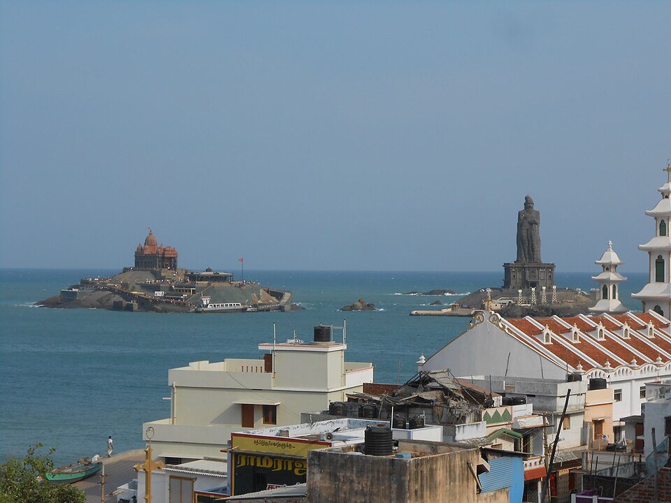
India's mainland ends at Kanyakumari in Tamil Nadu, where the Arabian Sea, the Bay of Bengal and the Indian Ocean meet. But the southernmost point of the country is Indira Point in the Great Nicobar Island, much further south.
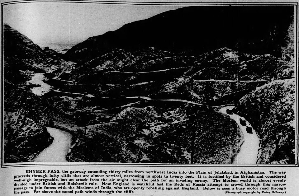
Though high mountains and seas surround the subcontinent, they have never cut it off completely. Mountain passes in the north-west, such as the Khyber and the Bolan, brought traders, armies and ideas from Central and West Asia. Sea routes carried Indian goods, religions and art to South-East Asia, East Africa and the Arab world.
Why it matters. India's neighbours share its rivers, its monsoon, its cultures and many of its security challenges. Long and often disputed borders call for careful management and good relations. Shared rivers such as the Ganga, the Brahmaputra and the Indus make water cooperation a key part of India's foreign policy.
India and the Indian Ocean
Look at a map of the eastern hemisphere, and India sits almost in the centre. The Indian peninsula juts deep into the Indian Ocean, between the Arabian Sea and the Bay of Bengal. This gives India a long coastline and makes it a natural meeting point of sea routes.
Ships carrying oil from West Asia and goods from Europe through the Suez Canal pass south of India on their way to the Strait of Malacca and East Asia. India's ports on both coasts can serve this trade. No other country has such a central position on the Indian Ocean, which is one reason why the ocean is named after India.
India also has two groups of islands. The Andaman and Nicobar Islands lie in the Bay of Bengal, close to South-East Asia, and the Ten Degree Channel separates the Andaman group from the Nicobar group. The Lakshadweep Islands, small coral islands, lie in the Arabian Sea off the coast of Kerala.
These islands extend India's reach far into the ocean. Around them India has large sea areas in which it alone has the right to fish and to explore for oil, gas and minerals. The Andaman and Nicobar Islands also sit close to the busy Strait of Malacca, which gives them great strategic value.
Why it matters. India's central location in the Indian Ocean shapes its trade, energy security and naval strategy. Most of its foreign trade by volume travels by sea. Protecting sea routes, developing ports and cooperating with other ocean countries are therefore central to India's economic and security interests.
One land, many regions
India's size and location together create remarkable variety. Within one country there are the world's highest mountains, one of its largest plains, an old plateau, a hot desert, two long coastlines and two groups of islands. Climate ranges from the cold deserts of Ladakh to the wet hills of Meghalaya and the dry sands of Rajasthan.
This variety of land and climate has supported a variety of ways of life. Herders move with the seasons in the mountains, farmers grow rice in the wet east and wheat in the drier north-west, and fishing communities live along the coasts. Many languages, foods and festivals grew out of these different settings.
Geography also helped create unity. The Himalaya and the seas mark a clear outer boundary, the monsoon gives a shared rhythm of seasons, and rivers such as the Ganga link many regions. Over centuries, pilgrimage routes, trade and shared traditions knit these regions together.
The word subcontinent is often used for India together with its neighbours in South Asia. This region is large and distinct enough, with its own mountain walls, river systems and monsoon climate, to be treated almost like a continent of its own.
Why it matters. Understanding India as a land of many regions helps explain differences in farming, settlement, development and culture. It also explains why policies that work in one region may not work in another. Planning by regions, with local conditions in mind, is therefore an important idea in Indian geography.
Mains ದೃಷ್ಟಿಕೋನ: ಏನು, ಏಕೆ, ಎಲ್ಲಿ ಮತ್ತು ಆಗ ಏನು
Location questions in Mains are rarely about facts alone; they ask what the location means. Here are four angles that connect this chapter to GS Papers I, II and III.
1. Location and climate. The Tropic of Cancer, the Himalaya and the surrounding seas together give India a monsoon climate with tropical warmth over most of the country. Answers can link latitude and relief to the seasons and farming.
2. Strategic location in the Indian Ocean. India's central position on sea routes, and the Andaman and Nicobar Islands near the Strait of Malacca, give it great strategic and economic importance. Answers can link location to trade, energy security, port development and maritime cooperation.
3. Borders and neighbours. Long land borders, shared rivers and varied terrain create both opportunities, such as trade and connectivity, and challenges, such as disputes, migration and security. Answers should balance geography with diplomacy.
4. One time zone or two. The 30° spread of longitude raises the question of a separate time zone for the north-east. Answers can weigh daylight use and energy savings against administrative simplicity and national unity.
Mains lens: practice questions and answer plans
ಈಗ ಈ ತಿಳುವಳಿಕೆಯನ್ನು ಲಿಖಿತ ಉತ್ತರಗಳಾಗಿ ಬದಲಿಸುವ ಸಮಯ. ಕೆಳಗಿನ ನಾಲ್ಕು ಪ್ರಶ್ನೆಗಳು UPSC ಶೈಲಿಯಲ್ಲಿ ಬರೆಯಲ್ಪಟ್ಟಿವೆ, ಆದರೆ ಇವು ನಮ್ಮದೇ practice questions, previous-year questions ಅಲ್ಲ. ನಿಮ್ಮ ಪರೀಕ್ಷೆಯ ನಿಜವಾದ previous-year questions ಅನ್ನು ಅಧಿಕೃತ ಪತ್ರಿಕೆಗಳೊಂದಿಗೆ ಹೊಂದಿಸಿದ ನಂತರ "Previous year questions" ಬಾಕ್ಸ್ನಲ್ಲಿ ಕಾಣಿಸುತ್ತವೆ.
Q1. "India's location has shaped its climate, economy and strategic role. Discuss." (250 words)
- Introduction: Give the latitude and longitude extent and the Tropic of Cancer.
- Body: Explain three effects: on climate (tropical and monsoon), on economy (coastline, ports and varied crops) and on strategy (Indian Ocean routes and islands).
- Conclusion: Location is a lasting asset that policy must use well.
Q2. "Examine the case for and against a separate time zone for north-eastern India." (150 words)
- Explain the 30° longitude spread and the two-hour difference in sunrise.
- Then give the benefits, such as daylight use and energy savings.
- After that, give the concerns, such as confusion in railways, banking and broadcasting.
- End with a balanced view.
Q3. "The Andaman and Nicobar Islands are of great strategic importance to India. Explain." (150 words)
- Describe their location, near the Strait of Malacca and South-East Asia.
- Next, link them to maritime security, trade routes and sea resources.
- Close with the need for careful, eco-sensitive development.
Q4. "Geography both separates and connects the Indian subcontinent. Comment." (150 words)
- Give the barriers: the Himalaya, the Hindu Kush and the seas.
- Then give the links: mountain passes, sea routes, shared rivers and the monsoon.
- Finally, draw the lessons for regional cooperation.
Useful keywords: latitude, longitude, Tropic of Cancer, Indian Standard Time, 82°30′E, coastline, land frontier, Palk Strait, Gulf of Mannar, Indira Point, Ten Degree Channel, Strait of Malacca, Indian Ocean rim, subcontinent, strategic location.
Quick revision
- Mainland India: 8°4′N–37°6′N and 68°7′E–97°25′E; wholly in the Northern and Eastern Hemispheres.
- The Tropic of Cancer crosses 8 states: Gujarat, Rajasthan, Madhya Pradesh, Chhattisgarh, Jharkhand, West Bengal, Tripura, Mizoram.
- Area about 3.28 million sq km (2.4% of world land), 7th largest country.
- 3,214 km north–south, 2,933 km east–west; land border about 15,200 km, coastline about 7,516.6 km with islands.
- IST is based on 82°30′E (near Mirzapur), 5 h 30 min ahead of GMT; sunrise in Arunachal is about two hours earlier than in Gujarat.
- Seven land neighbours; longest border with Bangladesh, shortest with Afghanistan.
- Palk Strait and Gulf of Mannar separate Sri Lanka; Ten Degree Channel separates the Andaman and Nicobar groups.
- Kanyakumari is the mainland's southern tip; Indira Point is the country's southernmost point.