BPSC Stenographer in BPSC · Module 24 · basic depth · 9 min
Relief of the ocean floor
What BPSC Stenographer in BPSC asks from this chapter
Syllabus lines this chapter covers:
Written: GS 50, General Science and Mathematics 50, Mental Ability 50 · General science: physics, chemistry, biology, geography
BPSC Stenographer in BPSC questions from this module are being sorted into our bank.
Cut to basic depth for BPSC Stenographer in BPSC. 21 deeper paragraphs are in the full chapter.
Start from zero: the hidden half of the planet
Look at a globe and you see mostly blue. Oceans cover about 71% of Earth's surface and hold about 97% of all its water. Yet for most of history, people knew the ocean only as a flat surface, with no idea of the mountains and valleys hidden underneath.
One world ocean, five names
The oceans are joined together as one world ocean, but we divide it into five: the Pacific, the largest and deepest; the Atlantic; the Indian; the Southern around Antarctica; and the Arctic, the smallest. Smaller parts partly enclosed by land are called seas, such as the Arabian Sea and the Mediterranean.
Ocean water is part of the hydrological cycle. The Sun evaporates water from the sea, the vapour condenses into clouds, rain and snow fall on land and sea, and water returns to the ocean through rivers and groundwater. Almost all the rain that feeds Indian farms began as ocean water.
Why it matters. Oceans control climate, feed billions through fisheries, carry most world trade and hold huge reserves of energy and minerals. Knowing the shape of the sea floor is the first step to using and protecting them.
How we measure the depths
Early sailors measured depth by lowering a weighted rope until it touched the bottom. Depth was counted in fathoms, where one fathom is 6 feet, or about 1.8 m. This was slow and worked only in shallow water.
Echo sounding and satellite altimetry
The big breakthrough came with echo sounding, or sonar. A ship sends a pulse of sound down to the sea floor and records how long the echo takes to return. Since the speed of sound in water is known, the time gives twice the depth, and continuous soundings draw a profile of the floor.
Since the late twentieth century, satellites have also helped. They measure the height of the sea surface very precisely, and because underwater mountains slightly pull water towards them by gravity, the surface bulges over them and dips over trenches. Combining ship soundings and satellite data has produced the detailed maps we use today.
Even so, only part of the deep sea floor has been mapped in fine detail. International efforts are working to map the entire ocean floor at high resolution.
Why it matters. Accurate sea-floor maps are needed for laying undersea internet cables and pipelines, for submarine navigation, for tsunami modelling and for claiming rights over the continental shelf.
From the coast to the deep: shelf, slope and plain
If you could drain the ocean and walk out from the beach, you would first cross the continental shelf. It is really the drowned edge of the continent, sloping very gently, usually by a degree or less. On average it is about 80 km wide, and its outer edge is usually less than about 200 m deep, though shelf depths range from about 30 m to 600 m.
A cross-section of the ocean floor
Shelves are wide where large rivers bring sediment or where the land is low, and narrow where mountains stand close to the coast. Much of the shelf was dry land during the ice ages, when sea level was over 100 m lower. Because sunlight reaches the shallow water and rivers bring nutrients, shelves hold the world's richest fishing grounds, and their thick sediments contain oil and gas, such as Mumbai High off India's west coast.
At the shelf break, the floor suddenly steepens into the continental slope, which drops to depths of about 2,000 to 3,000 m. The slope is often cut by deep, steep-sided submarine canyons, many lying off the mouths of large rivers; the "Swatch of No Ground" in the Bay of Bengal is one such canyon. At the foot of the slope, sediment sliding down piles up as a gentle continental rise.
How deep is each part?
Beyond lies the deep sea plain or abyssal plain, at depths of about 3,000 to 6,000 m. It is among the flattest surfaces on Earth because fine sediment has blanketed the rough rock underneath. These deep-sea sediments include clay blown from land and oozes made of the tiny shells of dead sea creatures.
Why it matters. The shelf decides a country's fishing wealth and offshore oil, which is why its outer limit is part of international law. Canyons and slopes guide sediment and are sites of undersea landslides that can trigger tsunamis.
Ridges, seamounts and trenches
The most striking features of the deep ocean are made by plate tectonics, which you met in plate boundaries and their landforms. Where plates pull apart, rising magma builds mid-ocean ridges, long chains of underwater mountains that wind through all the oceans like the seam of a tennis ball. Along the crest runs a rift valley where new ocean floor is born.
Ridges and trenches of the world
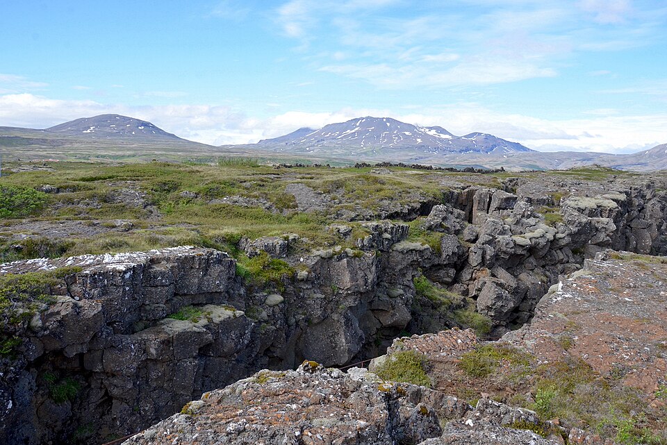
The Mid-Atlantic Ridge runs down the middle of the Atlantic from near the Arctic to the far south. In Iceland, it rises above sea level, and you can walk across the rift between two plates. The ridge system as a whole is the longest mountain range on Earth, though almost all of it is underwater.
Scattered over the ocean floor are seamounts, underwater volcanoes that rise steeply but do not reach the surface. Some volcanoes once reached sea level, were planed flat by waves and then sank as the ocean floor moved away from the ridge and cooled; these flat-topped peaks are called guyots. Chains of volcanic islands and seamounts, such as the Hawaiian chain, form as a plate moves over a fixed hotspot in the mantle.
The Mid-Atlantic rift on land in IcelandPhoto: Olga Ernst, CC BY-SA 4.0, via Wikimedia Commons
The deepest parts of the ocean are long, narrow trenches, formed where one plate dives beneath another at a subduction zone. Most lie around the edge of the Pacific, often beside curved chains of volcanic island arcs such as Japan and the Aleutians. The deepest of all is the Mariana Trench in the western Pacific, which reaches about 11 km at the Challenger Deep, deeper than Mount Everest is high.
Why it matters. Trenches mark the zones of the world's biggest earthquakes and tsunamis, and ridges host hot springs with unusual life and metal-rich deposits. These features also confirm plate tectonics, the central theory of physical geography.
Quick revision
Ocean floor exam traps
Oceans: about 71% of the surface, about 97% of Earth's water. Pacific largest and deepest; Arctic smallest.
Shelf (gentle, about 80 km wide on average, edge usually under about 200 m) → slope with submarine canyons → rise → abyssal plain (about 3–6 km, oozes).
Exam-style questions on this chapter. Pick an answer to see the explanation. 0 of 9 answered
A flat-topped submarine mountain is called a:
Consider the following statements:
1. Most ocean trenches lie around the margins of the Pacific Ocean.
2. Trenches form at divergent plate boundaries.
Which of the statements given above is/are correct?
Which one of the following is the correct sequence of ocean-floor features moving away from the coast?
Continental shelves are rich fishing grounds mainly because:
The deepest part of the Indian Ocean is the:
Consider the following statements about the law of the sea:
1. The territorial sea extends up to 200 nautical miles from the coast.
2. In its Exclusive Economic Zone, a coastal country has rights over fish and seabed minerals.
Which of the statements given above is/are correct?
The Mid-Atlantic Ridge rises above sea level in:
Echo sounding measures ocean depth by:
The Bengal Fan on the floor of the Bay of Bengal is mainly built of:
Previous year questions
Previous year questions for UPSC CSE will appear here once each one is checked word for word against the official question paper.
Frequently asked questions
Why is the continental shelf important?
The shelf is shallow and sunlit, so it is rich in fish, and its sediments hold oil and gas, such as Mumbai High off India's west coast.
What is the deepest point in the oceans?
The Challenger Deep in the Mariana Trench of the western Pacific, nearly 11 km deep, is the deepest known point.
What is a guyot?
A guyot is a flat-topped seamount. It was once a volcanic island whose top was worn flat by waves before it sank below the sea.
How far does India's Exclusive Economic Zone extend?
Under the UN Convention on the Law of the Sea, the EEZ extends 200 nautical miles from the baseline, giving India rights over fish, oil and minerals there.