

HPSC HCS · Module 31 · Mains depth · 14 min
Australia, Oceania and Antarctica: the southern lands
What HPSC HCS asks from this chapter
Syllabus lines this chapter covers:
- Prelims Paper I: General Studies · Indian and world geography
- Mains · GS I: culture, modern and world history, society, geography, Haryana issues
2 HPSC HCS questions in our bank come from this module (The world map).
Read at full depth: basics, the standard layer and the Mains analysis.
Start from zero: the lands of the far south
This chapter covers the lands of the Southern Hemisphere that lie far from the other continents. Australia is the smallest continent, so small that it is sometimes called an island continent. Oceania is the wider name for Australia, New Zealand and the thousands of islands scattered across the Pacific Ocean. Antarctica is the ice-covered continent around the South Pole.
Australia is the flattest continent, and apart from Antarctica it is the driest inhabited one. The Tropic of Capricorn passes through its middle, so much of the interior lies under the dry subtropical high-pressure belt. This is the same reason that makes the Sahara and the Kalahari dry.
Because Australia and the Pacific islands were cut off from other lands for millions of years, they developed unique animals and plants. Kangaroos and koalas are marsupials, mammals that carry their young in a pouch, and eucalyptus trees dominate many forests.
Why it matters. Australia is a major supplier of minerals and a key partner in the Indo-Pacific. Antarctica holds the record of past climate in its ice, and the Pacific islands are the front line of sea-level rise.
Australia: plateau, basins and reef
Australia has three relief regions. The Western Plateau covers about two-thirds of the continent. It is made of very old rocks and holds the great sandy deserts: the Great Sandy, Gibson and Great Victoria deserts. It is also rich in minerals, especially in the Pilbara region of Western Australia.
The Central Lowlands lie in the middle. They include Lake Eyre, a usually dry salt lake that is the lowest point of the continent, and the basin of the Murray–Darling, Australia's largest river system, which waters its main farming region in the south-east. Beneath the lowlands lies the Great Artesian Basin, one of the largest underground water basins in the world.
An artesian basin works like this. Rain falling on the Great Dividing Range in the east seeps into a layer of porous rock that tilts down to the west between layers of watertight rock. The water is trapped under pressure, so when a well is drilled far to the west, it rises on its own without pumping, giving water to cattle and sheep stations in the dry interior.
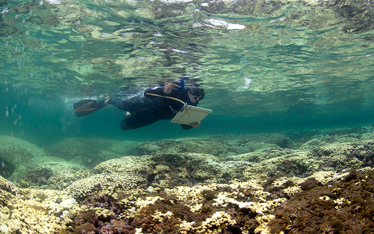
The Eastern Highlands, or Great Dividing Range, run along the east coast and catch rain from the moist south-east trade winds. Off the coast of Queensland lies the Great Barrier Reef, the largest coral reef system in the world, stretching for over 2,000 km. Corals need warm, clear, shallow and salty water, and when the sea gets too hot they expel the algae living in them and turn white, which is called coral bleaching.
Why it matters. The artesian basin shows how geology can bring water to a desert. The Great Barrier Reef's repeated bleaching is a warning sign of ocean warming.
Australia's climate, resources and people
Australia's climate forms rings around its dry centre. The north has a tropical savanna climate with summer monsoon rains, the dry interior is desert and semi-desert, and the east coast is warm and moist. The south-west around Perth and the south around Adelaide have a Mediterranean climate, while the south-east and Tasmania are temperate and mild.
Australia is one of the world's great mining nations. It is a leading exporter of iron ore from the Pilbara, coal from Queensland and New South Wales, bauxite, gold, natural gas and lithium. Much of this goes to Asian markets, including India.
Farming is extensive: huge farms with few workers. Australia is famous for sheep rearing and merino wool, grazed on vast "stations" in the semi-arid lands, and for wheat grown in the Murray–Darling basin and the south-west. Cattle ranching spreads across the north.
Most Australians live in a few large cities along the south-eastern and eastern coasts, such as Sydney, Melbourne and Brisbane, and in Perth in the south-west. The dry interior, often called the Outback, is very thinly peopled. Aboriginal and Torres Strait Islander peoples have lived on the continent for tens of thousands of years.
Why it matters. Australia is a major supplier of coal, iron ore and critical minerals to India. Both countries cooperate closely in the Indo-Pacific and in the Quad grouping.
New Zealand and the Pacific islands
New Zealand lies about 2,000 km south-east of Australia, across the Tasman Sea. It has two main islands. The South Island is crossed by the high Southern Alps, with glaciers and fjords on its south-west coast, while the North Island has active volcanoes, hot springs and geysers. New Zealand sits on the boundary between the Pacific and Australian plates, so it has frequent earthquakes.
Its mild, moist climate grows rich pastures, so New Zealand is a leading exporter of dairy products, lamb and wool. The Māori are its indigenous people.
The thousands of islands of the Pacific are grouped into three cultural regions. Melanesia ("black islands") lies north-east of Australia and includes Papua New Guinea and Fiji. Micronesia ("small islands") lies to the north and includes Guam and the Marshall Islands. Polynesia ("many islands") forms a huge triangle with Hawaii, New Zealand and Easter Island at its corners.
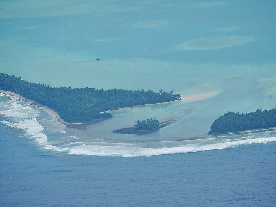
Many Pacific islands are volcanic, while others are low coral atolls. An atoll is a ring of coral reef enclosing a lagoon. It forms when coral grows up around a volcanic island that slowly sinks, so the reef keeps rising while the island disappears below the water. Atoll nations such as Tuvalu, Kiribati and the Marshall Islands rise only a few metres above the sea, so sea-level rise threatens their very existence.
Why it matters. The Pacific islands show the human cost of climate change most sharply. India engages them through the Forum for India–Pacific Islands Cooperation, and they are part of the wider Indo-Pacific.
Antarctica: the frozen continent
Antarctica surrounds the South Pole and is larger than Europe or Australia. Almost all of it is buried under an ice sheet that is, on average, about two kilometres thick. This ice holds most of the world's fresh water, and if it all melted, sea level would rise by many tens of metres.
Antarctica is the coldest, windiest and, because of its thick ice, the highest continent on average. The Transantarctic Mountains divide it into the larger, higher East Antarctica and the smaller West Antarctica, whose ice rests on ground below sea level and is more at risk of melting. Huge floating ice shelves, such as the Ross and Weddell ice shelves, fringe its coasts. Around it flows the Antarctic Circumpolar Current, which isolates the continent and keeps it cold.
Antarctica has no permanent population, only scientists at research stations. The Antarctic Treaty, signed in 1959, reserves the continent for peaceful and scientific purposes and freezes all territorial claims. Its Protocol on Environmental Protection, signed in Madrid in 1991, bans mining and protects the environment.
India sent its first expedition in 1981 and set up its first station, Dakshin Gangotri, in 1983; it was later buried in ice and is now used only as a supply base. India's active research stations are Maitri (1989) and Bharati (2012), run by the National Centre for Polar and Ocean Research in Goa. In 2022, India passed the Indian Antarctic Act to regulate Indian activities there in line with the treaty.
Why it matters. Antarctic ice cores record hundreds of thousands of years of past climate. Its ice sheets will decide how much the seas rise, which matters for India's long coastline.
Climate change in the southern lands
The lands of this chapter show the effects of climate change very clearly. Australia faces longer droughts, record heatwaves and severe bushfires, such as the huge fires of 2019–20 that burned millions of hectares. The Murray–Darling basin is under stress as farms, towns and rivers compete for scarce water.
At sea, warmer water has caused repeated mass bleaching of the Great Barrier Reef. Coral reefs cover a tiny share of the ocean floor but shelter a large share of marine species, so their loss affects fisheries and coastal protection.
In the Pacific, low atolls face sea-level rise, salt water entering their freshwater lenses, and stronger storms. Some island governments are planning for the possible relocation of their people, raising new questions about "climate refugees" and the rights of nations whose land may disappear.
In Antarctica, parts of the West Antarctic ice sheet and the ice shelves are thinning as warmer ocean water melts them from below. Scientists watch them closely because their collapse could raise sea level by several metres over the coming centuries.
Why it matters. These regions are early warnings for the whole planet. For India, rising seas and warming oceans threaten coastal cities, fisheries and the Sundarbans.
Mains lens: what, why, where and so what
This chapter supports GS Paper I (world physical geography, important geophysical phenomena, distribution of resources) and links to GS Paper II (Indo-Pacific, Antarctic Treaty) and GS Paper III (climate change, conservation). Here are four angles.
1. Dry continent. Subtropical high, artesian water and extensive farming.
2. Coral. Great Barrier Reef, atolls and bleaching.
3. Resources. Iron ore, coal and lithium for India.
4. Antarctica. Ice sheets, sea level, the treaty and India's stations.
Mains lens: practice questions and answer plans
Now turn this understanding into written answers. The four questions below are written in the UPSC style, but they are our own practice questions, not previous-year questions. The real previous-year questions of your exam appear in the "Previous year questions" box once we have matched them with the official papers.
Q1. "What is an artesian basin? Explain with reference to the Great Artesian Basin of Australia." (150 words)
- Draw the tilted aquifer between watertight layers.
- Note its use and the risk of overuse.
Q2. "Explain the conditions needed for coral growth and the causes of coral bleaching." (150 words)
- Temperature, light, depth, salinity, clear water.
- Warming, acidification, pollution; Indian reefs as examples.
Q3. "Why does Antarctica matter to India? Discuss in the context of climate change and the Antarctic Treaty." (250 words)
- Introduction: India's stations and the treaty.
- Body: Ice cores, sea level, monsoon links, governance.
- Conclusion: The Indian Antarctic Act and science diplomacy.
Q4. "Small island states are on the front line of climate change. Examine with reference to the Pacific atolls." (150 words)
- Atoll formation and low elevation.
- Sea-level rise, freshwater, relocation and loss and damage.
Useful keywords: smallest continent, flattest, Tropic of Capricorn, marsupials, Western Plateau, Pilbara, Great Sandy Desert, Lake Eyre, Murray–Darling, Great Artesian Basin, Great Dividing Range, Great Barrier Reef, coral bleaching, merino wool, extensive farming, Outback, Tasman Sea, Southern Alps, Melanesia, Micronesia, Polynesia, atoll, lagoon, Tuvalu, Kiribati, ice sheet, Transantarctic Mountains, ice shelves, Antarctic Circumpolar Current, Antarctic Treaty 1959, Madrid Protocol 1991, Dakshin Gangotri, Maitri, Bharati, Indian Antarctic Act 2022.
Quick revision
- Australia: smallest, flattest, driest inhabited continent; Tropic of Capricorn through the middle.
- Relief: Western Plateau (deserts, Pilbara), Central Lowlands (Lake Eyre, Murray–Darling, Great Artesian Basin), Great Dividing Range.
- Artesian: rain on the range → tilted porous layer → rises under pressure in western wells.
- Great Barrier Reef (Queensland): largest reef; bleaching from warming.
- Resources: iron ore, coal, bauxite, gold, lithium; sheep, merino wool, wheat.
- New Zealand: South Island (Southern Alps), North Island (volcanoes, geysers); dairy.
- Pacific: Melanesia, Micronesia, Polynesia; atolls = coral ring + lagoon around a sinking island.
- Antarctica: coldest, windiest, highest on average; ice sheet; Treaty 1959; Madrid Protocol 1991 bans mining.
- India: Dakshin Gangotri (1983), Maitri (1989), Bharati (2012); Indian Antarctic Act 2022.